
This book, written by Amy Isobel Rolland Drummond, a former resident of Alva, and published in 1953, outlines the historic and architecturally interesting buildings that could mostly be found at that time. Many of the buildings mentioned have since been updated or demolished, depending upon their general state.
OLD CLACKMANNANSHIRE
A description of Old Buildings illustrated with sketches, photographs, plans and a map
A. I. R. DRUMMOND
PREFACE
The purpose of this preface is to acknowledge the writer's debt to all who have advised and encouraged her in the illustrating, writing, printing and publishing of Old Clackmannanshire.
The arrangement of the booklet is based on Old Moray by R. G. cant, M.A.,published by The Elgin Society.
The writer is specially indebted to the following:
Miss M. L. HAIG, M.B.E., Stirling
Miss R. S. COWPER, M.A., Edinburgh
WILLIAM WALKER, A.R.E.
I. G LINDSAY, F.R.I.B.A.
Rev. T. CROUTHER GORDON, PH.D., D.F.C.
Rev. A. L. DRUMMOND, PH.D., F.R.I.A.S.
G. F. CUNNINGHAM, B.A.
INTRODUCTION
The Royal Commission on Ancient and Historical Monuments has already made a Report on Clackmannanshire as part of the old Kingdom of Fife. This survey described, succinctly, the castles and houses in the county, built from the medieval period until the end of the 17th century and several illustrations were provided by plans and photographs. From this Report and other publications of earlier and more recent date, one learns that the 'Wee Coonty' is rich in historic interest. The former county town of Clackmannan grew up on the eastern slope of King's Seat, the hill site of a royal castle, of which only the oldest portion, the tower, still stands.
Clackmannan appears to have been one of the hunting-seats of the Kings of Scotland, until David II sold it to a kinsman, Robert de Bruce, in 1359. From this time, the future burgh became more prosperous as a market town, with a Pow, or port-of-call, on the river Forth.
When Clackmannan was growing larger, the present county town of Alloa was a small village, which owed part of its origin and development to the patronage of the Erskine family, who were granted the land by King Robert III in 1398. The castle, Alloa Tower, was not built however, prior to 1497, according to the wording of royal charters.* Alloa had a grain mill by 1489,** and became a market town, with a harbour on the river Forth. Vessels were registered and all custom-house business conducted from c. 1710. A large coasting trade developed and, also, a considerable trade with Holland, the Baltic and Portugal. Produce from these foreign countries came into Alloa and Stirling.
* T. Crouther Gordon, A Short History of Alloa.
** Alloa and Tullibody, edited by Dr Lauchlan Maclean Watt, 1902, p. 58.
The earlier prosperity of Clackmannan and its harbour gradually declined and, in 1822, the Sheriff Court was transferred to Alloa and it became the county town. Coal, wool, later brewing and distilling, were the principal sources of prosperity and employment in the district.
Small communities grew up along the north bank of the river Forth, as they did on the south side, through coastal industry and trade, such as salt pans, started by religious fraternities in the medieval period and continued by the laity, fishing and boat-building, e.g. Kennetpans and Cambus. The former hamlet was the river port for the distilling industry at Kilbagie village in the 18th century. Villages and hamlets also developed on either side of the broad Devon valley, bounded on the north by the Ochil Hills and on the south by a ridge of higher ground. In the medieval period, some hamlets extended under the overlordship of the family who owned the land and usually lived in a castle
built upon it, e.g. Dollar village: Castle Campbell; Sauchie village: Sauchie Tower.
The weaving of wool from the flocks of sheep, grazing on the Ochil Hills, became an important industry. Thus, as the population of the county gradually increased, hamlets grew into villages, the homes of numbers of weavers, who worked at handlooms in their own houses, until the earliest mills were built. Some of the villages became small towns, as time went on, and ranked as 'police burghs' by the 19th century, e.g. Alva, Tillicoultry.
When a mansion-house replaced the castle, or was attached to one side of the medieval tower, as at Alloa and Clackmannan, between the 16th and 18th centuries, the laird continued to be the patron of the village. During the 18th century he sought to improve the houses, or the general plan of the town or village, and to encourage the development of local industries, as did the 11th Earl of Mar at Alloa, and his kinsman, Sir John Erskine of Alva, the Earl of Argyll at Dollar and the Bruces of Kennet.
In the early 18th century, the gardens of Alloa House were replanned. The Earl of Mar invited Le Notre, landscape gardener to Louis XIV of France, to visit Alloa and advise him in the laying out of new gardens and policies which were much admired and became famous outwith the county.
Sir John Erskine started mining for silver, about 1712, in the glen west of Alva House, but after some initial success, the venture proved a failure. Both Dr Brandshagen, an experienced German engineer from Hanover, and Sir Isaac Newton, then Master of the Mint, were amazed at the exceptionally high standard of the ore, but the silver vein was soon exhausted. He was interested in the replanning of Alva on the west side of the burn in the form of a square enclosing a green.
These activities were interrupted by the Jacobite Rebellion of 1715, the Earl of Mar being Commander-in-Chief of the rebels. He died in exile at Aachen, but Sir John Erskine was more fortunate and eventually returned home. The Earl of Argyll and the Bruces of Kennet fought on the side of the Government.
After the disturbances of the '15 and '45 Rebellions, lairds turned from politics to estate improvement. Those who had supported the Government prospered, while the Jacobites were penalised; a number held humble positions to avoid taking the oath of allegiance to the Hanoverian king.
Before the present county boundaries were determined by the Boundary Commissioners, in the year 1891,* the eastern part of the parish of Logie and a small portion of Stirling parish, at Cambuskenneth, were included in Clackmannanshire. Thus, this county could, until that time, claim the historic Abbey of St.Mary, Cambuskenneth, founded by King David I in c. 1147,** built in the First Pointed style. In 1326, the Scottish Parliament met within its walls, including, probably for the first time, representatives of the civic corporations as a constituent part of it. King James III and his queen were buried in the Abbey. Many Abbots of Cambuskenneth held high offices of state in Scotland. The temporalities of Cambuskenneth were conveyed by James VI to the Earl of Mar, who resided at Alloa.*** The property continued in the possession of his representatives, the Erskines of Alva, until the year 1709, when Sir John Erskine sold the lands and fishings to the Town Council of Stirling for the benefit of Cowane's Hospital.****
*Hay Shennan, Boundaries of Counties and Parishes in Scotland; Ordnance Gazetteer of Scotland, New Edition, published between 1892 and 1900, Cambuskenneth transferred
to the county of Stirling in 1891.
** Reg. Cenobii de Cambuskenneth, M.S., National Library, Edinburgh.
*** In 1562, the Abbey and lands were granted to John, Lord Erskine, by Mary Queen of Scots, who three years later created him first Earl of Mar.
**** Nimmo, History of Stirlingshire, vol. I.
Another interesting building, now in Stirlingshire, which used to be in the county of Clackmannan, is Blairlogie Castle, or 'The Blair', built first in 1513 or 1543. This date, whichever it may be, is on the pediment of a dormer window looking east, on the second floor of the main block. The figures are weathered and the third one is now incomplete. Above them is a pair of scissors, carved in relief, commemorating the appointment of Robert Spittal as tailor to Margaret Tudor, queen of James IV. This dormer window is supposed to have been immediately above the original entrance to the castle, before the east wing was added, in 1582, by Adam Spittal; this later date can be seen on the skew-put.
The exterior of the south gable of the main block no longer appears to be of 16th century character, because the recess of the original fireplace of the hall, at first floor level, has been transformed into an 'oriel' window in the later 19th century. Additions were then made on the north side of the castle. The interior still has some features of interest. In the main block, on the ground floor, are two barrel-vaulted apartments, no doubt originally storerooms. The hall above has a 16th century aumbry closed by a carved wooden door and an iron-studded door with a wooden bolt leading to the narrow, winding stair which rises to the second floor. A small oak cabinet originally fixed to the wall of a second floor apartment, served to conceal an entrance to a staircase leading to a corner turret from which escape could be made to the garden.
In Blairlogie village, there is a Relief Kirk (1761-62), a plain rectangular meeting-house, built of rubble, with walls harled and whitewashed. The old-world atmosphere has been well preserved; diamond paned windows of clear glass admit the sunshine, box pews and a canopied pulpit give character to the interior.
Some of the houses in the village belong to the 18th century and are inscribed with a date, e.g. a one-storey cottage in the Green Row and Montana Cottage; another beside it has an outside stair and is similar in style to houses of that period in Clackmannanshire. At the time they were built, Blairlogie was a centre where consumptives [Tuberculosis Sufferers] came to drink goats' milk. A flock of fifty goats was kept and visitors assembled at the stated hours of the milking. They were 'at the Goat's Milk at Blair'.
Gogar House, half a mile to the south of the village, is, in origin, a plain 18th century building with later additions. It had once a concealed private whisky-still below the wooden staircase. The low ceilings arrd small windows suggest an early 18th century date.
Powis House, one mile to the south of Logie Kirk, is attributed to the Adam Brothers. It is not one of their best works, but has attractive features, such as a pillared porch, panelled and carved woodwork and an 18th century iron grate. The stable buildings near the house are symmetrical on plan with a pleasing clock turret. The charming ruined Kirk of Logie was built in the 17th century. Its successor (c. 1800) was rebuilt a century later, the old steeple being incorporated.
Airthrey Castle was built in the castellated Adam style, in 1791, when Mr Robert Haldane was the proprietor. The design was attributed to John Adam, who lived in the mansion-house of Blairadam, Kinross-shire. The interior on the north side of the house has Baronial Revival features the south side still retains some charming rooms designed in the classical Adam style. Mr Robert Haldane had a wall built round the garden and policies and did much to beautify them, making an artificial lake.
Many of the original feu-charters granted to the inhabitants of villages in Clackmannanshire, like Dollar* or Alva, conveyed to them portions of land and building sites, on condition that they performed certain regular (feudal) services to their overlord. For instance, one feuar had to supply the Earls of Argyll at Castle Campbell with beer, another with grey oats for the horses, another with coal, another with horses for journeys, such as to the Earl's town house in Stirling, to attend the Court, others to transport wine from the Port of Alloa to Castle Campbell. The brewer who built his brewery on, or near, the 'Brewer's Knowe', at the foot of Dollar Glen, was traditionally supposed to supply the King with fifteen gallons of ale, of three different ages, whenever he passed by on the highway to and from Stirling and Falkland Palaces. The Kings, before they granted the lands of Dollar to noble families, owned them and are supposed to have had a hunting-seat there.
These feudal services were, as time went on, commuted into money payments. One survived even in the early years of the 20th century, the proprietor of the Lower Mains of Dollar was obliged to cart a certain number of loads of coal, annually, to Castle Campbell. No doubt, there are other examples of this practice, which still survived in some communities in the early 20th century. There was, however, about 1795,** no landed estate in Clackmannanshire that exceeded £4000 per annum; few amounted to £2000; the majority ran from £300 to £1000.
* The Dollar Magazine, Dollar Academy, vol. III, no. 11, 'Castle Campbell, etc.', Rev. Robert Paul, F.S.A. (Scot.), September 1904.
** John Francis Erskine, Esq., of Mar, A General View of the Agriculture of the County of Clackmannan (Board of Agriculture, H. Inglis, Edinburgh, - 1795).
Both ecclesiastical and secular buildings are constructed of local freestone. At Dollar, there is millstone grit and whinstone; the latter requires modern machinery to work it and is used more for road metal.
The historic and other buildings of architectural interest are arranged in the pages that follow, in four main sections, viz.,
I. Burghs and Villages;
II. Kirks;
III. Castles and Mansions;
IV. Smaller Houses and Other Structures;
V. Roads and Bridges.
The 17th century kirks are ruins, except St. Serf's, Alva, which is altered by 19th century additions.
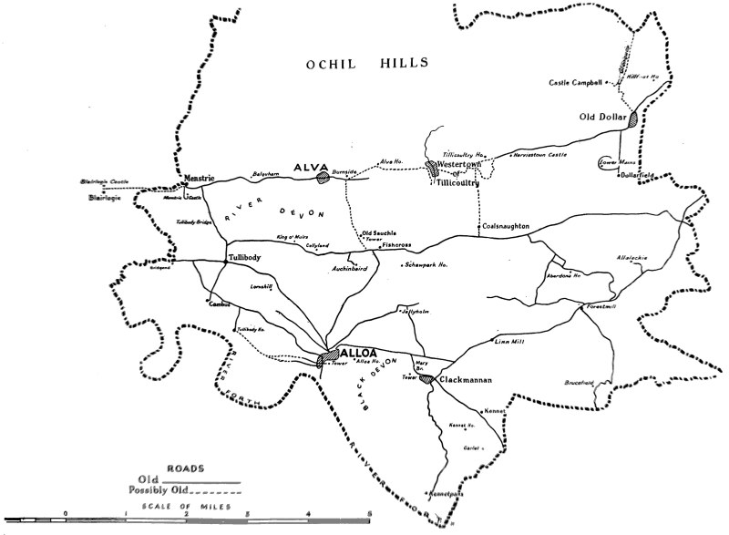
Each item is marked on the sketch map in the booklet.
I. BURGHS AND VILLAGES
CLACKMANNAN
In the former county town of Clackmannan, the oldest surviving houses date from the 17th century, according to evidence furnished by dated lintels and the style of the building construction; but some of the house walls may be earlier, as the style and rubble masonry did not change very much between the 16th and earlier 18th century, except that the quality of material and construction improved for houses of small and moderate size. Moreover, outside walls were harled at that time and so the masonry was concealed and preserved.
The houses in Clackmannan were all built of local freestone rubble, uncoursed, but in the later 18th century, coursed for houses of moderate size. There were no larger houses in the town and the nearest mansion was that attached to Clackmannan Tower, probably first built in the 16th century, as it was turretted and had crow-stepped gables, the turrets being of the pepper-pot type with conical roofs, like that of Blairlogie and of Menstrie Castles. Menstrie Castle is believed to be 16th century; it is built on the quadrangular plan, and has no tower. There are also later additions attributed to the early 17th century and Scoto-Renaissance ornament.
The sketch of Clackmannan Tower and mansion-house by Joseph Farington, R.A., made on 15th September, 1788, gives some idea of a mid-16th century house with later additions.
Small and moderate-sized houses in Clackmannan were roofed with red pantiles in the 17th and 18th centuries and these survive on many of the roofs. Pantiles were at first imported from the Low Countries to east coast ports of England and Scotland; later, they were manufactured in some districts where suitable clay was available. Before pantiles were introduced thatch or turves covered the roof timbers, lath and plaster. The houses were of two storeys and often had a stone forestair; the outer angle of the outside landing, in front of the first floor entrance, was supported by a pier, either plain or moulded. The base of the outside walls was often composed of very large, undressed stones; in some places they seemed to be taken from the bed of some local stream or any convenient quarry nearby. There was a second entrance to the two-storey house, as a rule, placed immediately below that at the head of the forestair. Typical examples of such houses may be seen in the High Street of Clackmannan, e.g. Nos. 2, 8, 10, 11, 13, 26, 28, but some of these are now [in 1952] demolished.
In other cases, there was a straight, wooden inside staircase, rising from the central entrance lobby on the ground floor to a small landing, e.g. No. 41 Main Street, dated 1680 and 1730, and other undated examples. North Vennel, North Street and Castle Street, especially on the east side, have still a few remaining old houses of one and two storeys, which are undated. The old one-storey house usually contained only a 'but and ben'. These two-storey houses had two apartments on each floor, supplied with one or more lockers and one, or two, recesses for salt-boxes on either, or one, side of the fireplace in the living-room kitchen. Sometimes there was a stoup-hole, or recess, for a flagon or a pail close to the entrance in the lobby wall. Water for all household purposes had to be carried from the nearest well in the street. The window openings were small, some measuring only three and a quarter feet by two and a quarter feet, a few larger, some smaller by one or two inches. These would have small glass panes fixed in a frame only if the household was well-to-do, as glazed windows were costly and uncommon except in important residences until the second half of the 18th century. Ground floors of ordinary houses were often of beaten earth, indeed, cottages still had this c. 1880; stone flags laid on the earth succeeded uncovered earth for ground floors, upper floors were of wood and, of course, much drier owing to their position. Local undressed, later half-dressed, or dressed, timber was used for the beams and, in early times, undressed timber even formed the door jambs. Crow-stepped gables, dormer and semi-dormer windows roofed with pantiles and sometimes graced by a decorated pediment were features typical of the later 16th and 17th centuries.
A carved sundial, a dated lintel, the trade emblems of the householder, dated and initialled panels, rolled or scrolled or tabled carved skew-puts and enriched forestair brackets and pillars, or piers, were the usual kind of ornament at that time, e.g. at the junction of the High Street and Kirk Wynd is a two-storeyed house, No. 2 High Street, with a sundial on the south-east angle just below the roof, and above the entrance is an oval panel surrounded by a garland; it is quartered and bears initials TT MC and the date, 1702. A two-storeyed house of moderate size, No. 3 Port Street, has a curious carved sundial at the south-east angle, situated on the lowest crowstep of the south gable. No. 10 High Street has a lintel over a ground floor window, dated 1668 and 1738, with the trade emblems of a butcher. No. 41 Main has one window lintel initialled TH KP and dated 1680, another dated 1730.
This type of domestic architecture was common to the whole county and surrounding shires. The classical revival affected the plan and elevation of moderate sized and smaller houses in the late 18th and early 19th centuries. The traditional type of house with a forestair is absent now from the villages of Clackmannanshire, except in old Dollar.
The Royal Oak Hotel, standing at the corner of the Market Place, has a curvilinear north gable, one of the few examples in eastern Scotland recalling Dutch models. The house is L-shaped on plan and the style is typical of late 17th and early 18th century domestic architecture in the county.
In the Market Place stand the tower and west gable of the Tolbooth, the house of justice, originally built in 1592. The bell-shaped roof of the tower resembles that of old St. Mungo's Church, Alloa, but is later in style and recalls the Tolbooth tower at Culross, built in 1783. The character of these towers show Dutch influence upon Scottish architecture of the 16th to the 18th century, noticeable in the eastern counties, which then had close commercial and cultural intercourse with the Netherlands.
Beside the Tolbooth rises the Market Cross of Clackmannan, with the original shaft, bearing the Bruce arms; the steps have been restored. The ball finial at the top of the Cross was placed there in 1897 and may have been brought from the principal gateway of the Tower. Near the Cross stands an upright un-hewn whinstone, on which rests the black 'clack', or stone, of Manan the Celtic sea-god; Mannan is the genitive of the name, thus 'Clackmannan' means the Stone of Manan.
The ancient sacred stone of the pre-Christian people was brought, according to tradition, from the Lookabootye Brae.*
* T. Crouther Gordon, The History of Clackmannan.
The Sheriffdom of Clackmannan goes back to the medieval period. The Sheriff and his Court sat in judgment on the steps of the Market Cross until the Tolbooth was built. The Court was held for the last time at Clackmannan on 21st January 1822, thereafter it was transferred to Alloa,** The Sheriff's house at Clackmannan (No. 33) stands in a walled garden of the south side of the High Street. The style of the building suggests a late 17th, or early 18th century date. It is of two storeys with crow-stepped gables and is roofed with pantiles.
** T. Crouther Gordon, A Short History of Alloa.
ALLOA
The oldest part of Alloa has now disappeared, and Paton and Baldwin's mills occupy the site, the southern side being near Alloa Tower. The houses, which once clustered along the banks of the Brathy Burn were of the same style as those described in Clackmannan; when one studies old photographs and a sketch, Bridge Street ran down to the burn and bridge. One photograph shows houses in streets near a hump-backed bridge, known as Old Bridge, and another, high, three-storeyed tenements enclosing the Market Place. Castle Street still has a few old houses. The Market Place was to the south-east of the Kirkgate, which runs along the north side of the churchyard in which stands the ruined 17th century Church of St. Mungo, with its small bell-shaped steeple.
A group of old houses with whitewashed harled walls, pantiled roofs and small voids still stands down at The Shore beside the harbour; these include the Mar Hotel. They have an attractive setting on the river Forth, with the Ochil Hills away to the north. It was here that David Allan, 'the Scottish Hogarth', was born in 1744.
In the Kirkgate, Tobias Bauchop, master mason, later an architect, built a two-storeyed moderate sized house for himself in 1695, in the newest style. The house stands on the north side of the street, facing south, and has attractive features, described in Section IV.
John, Earl of Mar, who lived in the later 17th and earlier 18th century at Alloa House, was a most gifted man, a valued friend of James Gibbs the well-known architect with engineering and architectural interests. He is said to have had a plan for a new town of Alloa, with a fine broad street to connect it with the harbour, but no such plan actually exists now. However, Broad Street runs down towards the harbour and the Lime Tree Walk at the southern end was planted in 1714* by grateful sailors, who suffered shipwreck and were succoured by the townsfolk.
* James Lothian, Alloa and its Environs, 1871.
Alloa traded considerably with Holland, the Baltic and Portugal. It was in the year 1710 that the shippers of the town asked the Earl, who took such an interest in the development of industry in the district, to provide a Custom House. In the early 18th century, Alloa became a port where vessels were registered and all custom-house business conducted. A large coasting trade also developed.* Coal was one of the sources of the town's prosperity and consequent growth. In 1715, steam power was first used to raise coal in the district.**
* New Statistical Account of Scotland, 1841 vol. viii.
** James Lothian, Alloa and its Environs, 1871.
In the Georgian Period Forth Street was one of the new residential parts of the town. The houses occupied only the north side and the front windows commanded a fine view across the river to the south. The houses still have some of their original features, such as pillared outside porches, e.g. at Salisbury House, resembling examples on the west side of Mar Street, mouldings round the voids, small rectangular window panes in sash frames, a few rolled and carved skew-puts, but no crow-stepped gables, as they were by that time considered old-fashioned. The roofs in Forth Street were steeply pitched, with no attempt at concealment, and covered with grey slates. Nos. 9 and 10 had fanlights above
the entrance. The stone staircases inside were in the centre of the back, one within a projecting rectangular portion and wound upwards to the second storey. Houses of the same period and somewhat later may be seen in Mar Street, west of the present High Street. Other examples are scattered here and there in what were 18th and early 19th century streets, e.g. Mar Place, Marshill, while Castle Street has some older houses. No. 15 Meadow Place was a late 18th century bank with a bank house. Georgian houses once imparted dignity to Broad Street and two still remain on the west side of The Walk. No. 15 has some features which suggest a late 17th century date with late 18th century additions and recalls the style of Kennetpans mansion-house. 'Linden' was originally strictly symmetrical on plan, with a three-storey main block and lower wings. Houses of this period in Alloa occasionally have dormer windows with slightly curved fronts; the void is filled with a large central light and two narrow side ones, all having small rectangular glass panes, e.g. the east side of Mar Street. Dormer windows had been going out of fashion, but they reappeared in less attractive forms in the Victorian Period. Fan-lights were quite common over the doors of the principal entrance. During the era of 19th century industrialism, Alloa expanded on the west side of the Brathy Burn, unfortunately without any definite plan.
VILLAGES
The Commission on Manufactures of 1597, by encouraging the woollen industry, gradually brought prosperity to Scottish sheep farmers and woollen mills. Coal had been wrought in the county from 1519, and by 1640 was extensively worked in the Clackmannan and Sauchie districts. Coal was transported from Alloa to Scottish and Continental harbours. The liquor trade became very prosperous during the 18th century until taxation killed it. All these industries encouraged the increase of population and the consequent growth of hamlets with a medieval origin into villages and, eventually, some expanded into 'police burghs', like Alva and Tillicoultry.
The old villages in the Hillfoots district, naming them from west to east, were Menstrie, Alva, Westertown and Eastertown (or Earlstown) of Tillicoultry and Dollar; these had woollen manufactures. Each village was situated beside a fast-flowing stream, which, from medieval times, drove a flour or a meal mill and also provided water for steam-driven mills, e.g. for woollen goods, at the foot of the glen. As a rule the village enjoyed the patronage of the laird on whose land it was built. He resided in a castle, later succeeded by an unfortified mansion-house in the 17th or 18th century. Each village usually had a pre-Reformation church or chapel, and the whole or part-time services of a parish priest. Post-Reformation parish churches in the county were first built in the 17th century, some are now in ruins, others have been substantially altered.
Villages on the south side of the Devon valley, like Tullibody, Sauchie and Coalsnaughton, were also under the protection of a noble landowner, who made part of his income and employed some of his people in local industries, such as coal mining, agriculture, distilling and brewing. The houses and cottages of all these communities were built in the same style as those described in Clackmannan, but some examples might be of poorer, therefore more perishable, materials, such as rubble mixed with clay, and thatch instead of pantiles, and unglazed windows covered with a pierced material.
At Menstrie the former main street is still preserved and is now known as Ochil Road; it is carried over the burn by a hump-backed bridge, above which is the 17th (1642) century mill. No. 16 Ochil Road used to be a laird's house owned by the Holbournes, whose arms are carved above the entrance. No. 7 Ochil Road is a one-storeyed cottage containing two to three rooms; it has a lintel over the entrance dated 1709 and on the south-east skew-put is a sundial dated 1712. No. 3 has a lintel dated 1719. No. 21 is a plain, harled, two-storey house, 41 ft. 5 in. by 20 ft. 1 in. over walls 2 ft. 7 and a half inches thick. The lintel over the entrance is dated 1752; the window openings measure only 3 ft. by 2 ft. on the ground floor and 2 ft. 8 in. by 2 ft. on the upper floor; they now each have sash frames filled with twelve small glass panes. It contains four rooms; the living-room is about 14 and a half feet square and the ceiling 7 and a half feet high on the ground floor. The ceilings of the two upper floor apartments are only 6 ft. 5 in. high. The entrance is still furnished with a large wooden bolt, or bar, for closing the door securely at night; it measures about 4 and a half feet long and 9 inches in circumference.
The hamlet of Damsburn, about a quarter mile east of Menstrie, on the old high road, consists of a row of pantiled cottages and a larger two-storeyed house opposite the east end of the row. The cottages appear to date from the early 18th century according to their style.
Alva village in the 16th-17th century seems to have occupied land between the burn and the site of the Parish Church, i.e. the Strude and Braehead areas, as there are early feus recorded* in that part, and also near the upper and middle bridges over the burn, e.g. the east end of Beauclerc Street and Duke Street, all near the west bank of the burn opposite and also south of the meal mill, which stood on the east bank.
* R. S. Cowper, 'The Stones of Alva' (Alloa Circular, June 1952).
In the early 18th century Sir John Erskine of Alva House planned to rebuild the village in the form of a square, with the village green, on which the parish school was to stand, in the centre, and each house was to have a garden at the back. This square is still known as Green Square, but many of the old houses have disappeared, or have been altered. The east, west and north sides were built during the 18th century; the west side in 1719. John Johnstone, Esq., of Alva Estate, also made a plan of the village. The west end of the north side included property of 17th century date, the east and north sides were planned by John Johnstone, Esq. (b. 1734 d. 1795), who tried to improve the sanitation of the village in the Dalmore area, where a 'neat necessary house' was built in 1782. Other old houses may be seen in Beauclerc Street, originally the Back Row on the old high road, and in Duke Street, the intended north row on the south side of this road. No. 6 Duke Street has rolled skew-puts, enriched by a narrow cable ornament; the house is now L-shaped. Between Nos. 36 and 27 Beauclerc Street rises a gable wall with a single moulded club-skew; this feature is sometimes found elsewhere; in Alva no gable is entirely crow-stepped. The north side of Erskine Street was the most southerly row of houses in Alva during the 18th and early 19th centuries, and was then called the Nether Row. * Water for household purposes was drawn from wells in the streets supplied by natural springs and streams, e.g. the Strathy Water. Early 18th century houses stood also at the Strude. The jail was close to the middle bridge over Alva burn and Courthill Inn on the south-west slope of Braehead. There was a baron's court-house with cells on the site of Burnside Farm-house and the cells were incorporated in the house and were seen by the present farmer, Mr R. C. Gray, during reconstruction work. A royal charter of 1542** refers to the fortalice, or castle of the Barony and another, of 1629, to the 'manerie loco'.**
* No. 7 Erskine Street still contains the original beams over the kitchen-living-room.
** Reg. Mag. Sig. Scot., vol. iii.
Two of the three villages in Tillicoultry Parish remain, as Earlstown or Eastertown was destroyed. Westertown on the east bank of the burn, from which the present Tillicoultry village developed, and Coalsnaughton on the south side of the Devon valley have a few old houses. A picturesque smiddy, with white-washed rubble walls and pantiles, may be seen at Coalsnaughton.
Old Dollar village still stands on the steep hillside east of the stream flowing down the glen below Castle Campbell. It now has only two streets of houses, High Street (the former main street) and Hillfoot Road. At the west end of the village the old highway is carried over the stream by means of a humped stone bridge. About the middle of the steep ascent through the village, there occurs a level where the two streets meet, possibly the site of the market square. The houses on the north side appear to be the oldest still standing, e.g. No. 3 Hillfoot Road, a house with two cottages beside it which have crow-stepped gables. One house and these cottages are still roofed with pantiles. Farther up Hill-foot Road, there are three cottages of picturesque character, Burn-Green Cottage, The Aikers, Broomyknowe; they have rolled skew-puts and pantiled roofs. Nos. 12 and 16 High Street are also attractive.
The modern village of Dollar, which has still a few Georgian houses situated here and there, is built on either side of the present main road. There are several interesting early 19th century housest of moderate size, standing in gardens on the outskirts of the village, e.g. Mount Devon, Woodcot,* Kellybank, Ochilton, etc. Dollar Academy, designed by the well-known Edinburgh architect W. H. Playfair, in his Grecian style, was founded in 1818. The masters' houses in Academy Place are also attributed to him. The porter's lodge, to the north of the Academy, is a charming early 19th century house of one storey with an addition at the north end. There is a moulded cornice and triangular pediment over the entrance and moulded drip-stones over the voids of the eastern front.
* Woodcot still retains fine examples of brass and iron early 19th century grates in the public rooms.
On the ridge of high ground, forming the south side of the Devon valley, are situated, west to east, Tullibody, Coalyland, Old and New Sauchie, Fishcross and Coalsnaughton villages.
Tullibody and Old Sauchie are medieval in origin. Tullibody had a pre-Reformation church in the 12th century, served by a parish priest. Baingle Brae is traditionally the site of the memorial, a single standing stone, of an ancient battle between the Picts and Scots. There may have been a medieval castle on the Brae. Later Tullibody House was built on flat ground near the river Forth. The present mansion was built in the second quarter of the 18th century, when an older house near it was pulled down.
Old Sauchie, near the Tower, has almost disappeared. There is now a group of buildings and a dwelling-house near the remains of a walled garden belonging to the Tower. New Sauchie probably began to be built when the Schaws moved from the mansion near the west wall of the tower to Schaw Park House, during the 18th century. Schaw Park is now roofless and stands on Alloa golf course between Fishcross, a modern village, and New Sauchie. The latter had a main street, sloping south-westwards, with old pantiled houses on each side, but these are regarded as being unfit for habitation now and will soon be swept away. This village used to be called Newton-Shaw. Nos. 21 and 23 Main Street had scrolled skew-puts enriched with cable ornament and pantiled roofs. Nos. 36, 38, 40, 42, have scrolled skew-puts.
Kennet Village, east of Clackmannan, was probably built in the second half of the 18th century. It was for miners who worked on Kennet Estate and their families. The houses are built in a row on the north-east side of the main road, running from Clackmannan to Kincardine-on-Forth, which seems to follow the course of the old high road. The houses are of one storey and an attic and contain about three rooms. They are well built of grey free-stone rubble and are roofed, some with grey slates, some with the original pantiles. They each have a small front garden, bordered by a low stone wall (Ruskin's 'moral boundary') and a larger back garden, the ground occupied by house and garden being about half an acre. By 1840 Mr and Mrs Bruce of Kennet Estate built a 'handsome schoolhouse and schoolmaster's house, endowed it, and provided it with a garden'.
Coalyland or Collyland, and Coalsnaughton are both mining villages, probably dating from the late 18th, or early 19th century. Coalyland used to have a larger number of inhabitants, but now only a few of the picturesque whitewashed, pantiled cottages are occupied. Coalsnaughton has expanded to the east and west and down the steep hill towards the village of Devonside and Tillicoultry.
Kilbagie, south-east of Clackmannan, off the high road to Kincardine-on-Forth, grew up in the 18th century through the short-lived prosperity of the whisky trade. The liquor was shipped from Kennetpans pier, which formerly had saltpans. The village is supposed to have erected one of the earliest threshing mills. The Feu Contract between Robert Bruce, Lord Kennet, and James Stein, a farmer at Kilbagie Farm, is dated 31st October 1776 (Kennet Chartulary, pp. 69, 70). This mentions Mr Stein's 'Distillery and Mill for grinding Malt and other Grain'. The family of Stein grew wealthy for a time through trade in whisky and lived in Kilbagie House, a solidly-built square plain later 18th century house of moderate size. Steins also lived at Kennetpans. There are a few houses near the harbour of Kennetpans (east of the mansion-house) which appear to be of early 18th century style.
The mansion became the home of the Steins* engaged in distilling at Kilbagie. A coloured print, copied by A. Ritchie and Son, Edinburgh, shows Kennetpans harbour in c. 1840, when it was very busy. Several railways ran from Kilbagie distillery and other buildings to the water's edge. The trucks were loaded and un-loaded into boats and funnelled ships plied up and down the river.
* In the Kennet Chartulary there is a Feu Charter, dated 8th November 1756, by Mr Robert Bruce of Kennet, Advocate (later Lord Kennet), in favour of John Stein and Margaret Caldorne his Spouse, granting them 'All and heall half ane Aiker of ground at Craigtown pans, commonly called Kenett pans, with the heall Tenements of houses Teinds and others within mentioned'.
The buildings of the Forth Paper Mills now occupy the site of the 18th century distillery at Kilbagie.
Cambus village, near the mouth of the river Devon, where it joins the Forth, has several picturesque 18th century cottages.
II. KIRKS
THE old Parish Church of St. Mungo's, Alloa, is now a ruin. Only the west gable with the bell-tower remains. The tower resembles that of the Tolbooth at Clackmannan, probably built in the 18th century. The church has been oblong on plan with a north aisle. The walls are of rubble, but the upper part of the tower is of ashlar and terminates in a bell-shaped steeple roofed with slates. On the inside of the west gable is a rough niche containing a crudely carved figure in 17th century costume, described in an inscription of later date as St. Mungo. The church was repaired and enlarged in 1680.* The masons employed for this work included Tobias Bauchop, or Baak. Again, in 1717, the church was too small to accommodate the members and a gallery was erected at the west end, Tobias Bauchop being one of the masons.**
* New Statistical Account of Scotland, c. 1848, vol. viii; Roy. Com. Anc. Hist. Mon., Fife, Kinross and Clackmannan, no. 587.
** Alloa and Tullibody, edited by Dr Lauchlan Maclean Watt, 1902.
The old Parish Church of St. Serf's, Alva, was rebuilt* by Alexander Bruce of Alva in 1631-32.
* Old Statistical Account of Scotland,. no. iv, Parish of Alva, 1796; New Statistical Account of Scotland, vol. xviii.
He procured the disjunction of Alva from Tillicoultry Parish. The walls and roof were left un-plastered, the seats became ruinous and the windows were small and ill-placed. Into the west gable, the older portion of the present church, is built a stone bearing the Bruce arms. On the upper part, flanking the shield, are the date 1631 and the initials for Alexander Bruce. Above the west entrance of the church is inserted a lintel inscribed in Roman characters 'Remember to keip holy the Sabboth day 1637'. The bell is said to be inscribed 'They who me giveth ar David Jenkin William Bell to Alva Kirk cursed be that wretch who me preventeth from sacred use or else doth sell. Anno 1633'. A rhyming couplet, or quatrain, is the result of rearranging this inscription and probably the surname 'Bell', being at the end of the second line and 'sell', which rhymes with it, the last word of the fourth line. In the 17th century the roof of the church was a mixture of 'fog' (moss), thatch and slates. The slaters and masons who repaired the church fabric during the last quarter of the 17th century were given drink money as a reward. For instance, Robert Staker received 1 pound Scots for gathering 'fog' to repair the roof; William Rainy, smith, 2 shillings Scots for supplying nails; and John Steel, slater, 2 shillings 8 pence Scots. The church remained the same, except for repairs and the total slating of the roof, until the middle of the 19th century when it was altered. It was, and remains, T-shaped on plan.
A graveyard at the back of Tillicoultry House is all that remains to indicate the site of the old church dating earlier than the 18th century. A new church was built on the south side of the high road in 1773. It was a small, neat building, well-lighted, but not sufficiently seated for the size of the congregation drawn from the three villages of Westertown, Eastertown close to Tillicoultry House, and Coalsnaughton. The present church (Gothic Revival) was built c. 1820.
The old church of Dollar is a ruin standing on the east bank of the burn behind the old parish school, now a dwelling-house. The 17th century belfry is still standing and resembles that on Clackmannan Tower of the same period.
The old parish church of Tullibody is now a mere shell; it was oblong on plan, measuring 63 ft. 1 in. by 22 ft. 3 in., and evidently represents the nave of a Romanesque structure, rebuilt in the 16th century before the Reformation and later altered and enlarged. The walls are complete, and, except the east gable, are constructed with much cubical ashlar. To the north there has been a single void, a small 16th century window, later built up. The south wall has two doorways with moulded 16th century architraves, the eastern bearing on the lintel a pastoral staff, flanked by the date 1539. The east and west gables are crow-stepped and may be of 17th century date from the intake; the belfry on the west gable is of 17th century style. Against the east gable in the interior is the large Renaissance monument of George Abercromby of Tullibody, who died in 1699. His arms are in the pediment: Within a bordure engrailed on a chevron between three boars' heads erased a mullet. The church was used for services until c. 1900.
The new church of Tullibody was designed by the late Dr Macgregor Chalmers; it has a stone interior. A number of churches in the county were built in the Gothic Revival style after the Napoleonic Wars. St. Mungo's, Alloa, with its well-proportioned spire is a good example and forms a notable land-mark; likewise Clackmannan Church, which has a striking situation on the hill known as King's Seat rising from the flat landscape near the river Forth. The interior is a fine example of modern renovation. The architect of St. Mungo's was Mr Gillespie Graham.
Old Kirkyards: These are to be found at Tullibody, Alva, Tillicoultry, Dollar and Alloa.
III. CASTLES AND MANSIONS
THE CASTLES
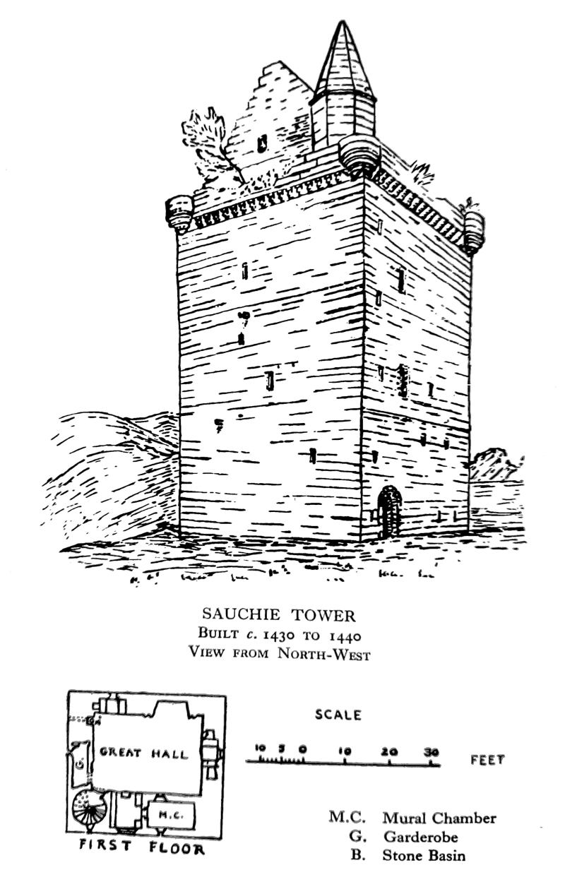
Clackmannan, Castle Campbell, Sauchie, Alloa and Menstrie. Alloa Tower is one of the largest towers in Scotland, measuring 62 and a half feet by 39 and a half feet externally and fully 68 ft. high.
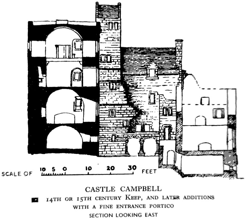
These castles, except that of Menstrie, are now represented only by their earliest portion, i.e. the strongly constructed rectangular tower of coursed freestone rubble, except Castle Campbell tower, which has walls with an outer and inner casing of squared ashlar. The tower at first was the entire castle, except for a few subsidiary buildings of more perishable materials. These towers, except for the north block of Clackmannan (14th century lower storeys) appear to date from the 15th century, according to their style and the documentary evidence available. They were built for attachment to a barmkin, or courtyard, in which, at later dates, additions were made to the tower; first a wing and, in some cases, a mansion-house. The walls of the additions or their foundations may still be seen, the best preserved being at Castle Campbell, where the wing although altered still stands, and the 16th century additions can be visualised from the remaining walls. The tower was residence and stronghold combined in the 15th century.
The earlier tower of Clackmannan, believed to be 14th century, was probably a royal hunting-seat close to the King's Forest of Clackmannan. David II sold the castle to his kinsman, Robert Bruce, in December 1359.* The battlements of the south wing have machicolations at the base, believed to be a 15th century feature in Scotland. They are very rarely found on castles of an earlier date and, if used at a later date, the machicolations are ornamental, not being provided with apertures; this type may be seen on the 16th century south range of Castle Campbell.
* Reg. Mag. Sig., under date 9th December, 1359.
The battlements of the Clackmannanshire towers have open, corbelled out, angle turrets and sometimes have a cap-house over the top of the newel staircase, which rises in one angle of the tower wall, e.g. Clackmannan at north-west angle of the north tower, Sauchie and Alloa. The battlements of Alloa are of considerable interest being, unusually, both stepped and crenellated, the main walls are noticeably thicker than other examples and the parapet walk is spacious. There is a fine open-couple slated roof still intact, without any crow-stepping, a feature found on the north tower of Clackmannan and Sauchie; Castle Campbell had the top vault inserted and there is a flat roof which is not the original one, which was probably of the pack-saddle' type like those of Clackmannan Tower and the south wing.
The square or rectangular window openings are rather small if they have not been enlarged at a later date. They may have been at least partly glazed by the 15th century, but glazed windows were rare and expensive and only the king and a few well-to-do noblemen could afford to possess them. It is known that King Robert the Bruce's new chamber at the royal manor, or palace of Cardross, built in 1329, had glazed windows.* The king lived at Clackmannan Tower in 1316, 1317 (probably in 1318) and visited this favourite hunting-seat frequently from 1323.
* Exchequer Rolls, vol. i, 1329.
Early glazed windows were often made portable so that they could be moved with other household goods from residence to residence. It is thus possible that the windows of the principal rooms in the 14th century tower of Clackmannan were provided with glazed windows while the king was in residence.
In the 16th and 17th centuries, extensions to the tower residence provided more accommodation for the owner and his household and, consequently, they enjoyed more privacy. Window openings were increased in size as the need for security against hostile forces and marauders decreased. A mansion house was built attached to the tower at Clackmannan and Alloa. Castle Campbell was extended round the courtyard; the south range, probably completed in the mid-16th century, contained a great hall, kitchen premises and several private rooms for the Earl of Argyll and his family. This extension also illustrates the early use of corridors and more than one newel staircase to provide easy communication between rooms and more privacy than when one room opened out of another. An inventory, made in 1595-96, provides valuable information as regards the original interior of the now ruined south range. At Sauchie Tower the extension, a separate mansion, was built against the west wall of enceinte and dated 1631. All these houses were still inhabited in the 18th century.
Menstrie House or Castle was the birthplace of Sir William Alexander, poet and statesman, in 1580; and In 1734 of Sir Ralph Abercromby, the hero of Aboukir. Recently the County Architect suggested that it should be preserved. It is a quadrangular type of fortified mansion, planned to occupy two or more sides of a courtyard, without a tower. This type of castle is found in Scotland in the later 15th century, but it is more typical of the 16th century. Menstrie has 17th century additions and Renaissance features, e.g. the enriched archway of the pend running under the west range into the courtyard. This castle has a 'pepper-box' type of roofed stair turret near the south-west angle, which is a
feature often found corbelled out at the angles of castles and mansions of this period. It is thought that turrets on Scottish castles were the result of French influence upon castellated architecture in this country, but some authorities believe these were the natural outcome of the development of defensive features on Scottish castles.
The principal apartment within all these castles was the great hall, where, in the 15th century as before, most of the daily life of the household was carried on. There was sometimes a separate kitchen, either on a lower floor, as in the towers of Castle Campbell and Alloa, or on the same floor, as at Clackmannan Tower, after the addition of the south wing, or on an entresol as at Sauchie Tower, which had a bakehouse below the level of the hall. The storeroom and cellar were on the ground floor, sometimes a special, short, straight mural staircase led directly down to it as at Castle Campbell. Above the hall floor was a bedroom floor, sometimes a 'solar' for the lord of the household occupied part of it, above that was the attic floor, which was usually a guard chamber with access to the parapet walk. There were mural chambers on each floor which provided a little privacy, when desired. One at Castle Campbell tower was used as an oratory, others may have been sleeping-places; a larger chamber might be used as a solar, if no other room was provided.
In the mansion-houses attached to the tower, the south range at Castle Campbell and at Menstrie, the great hall was placed at first floor level, with the private apartments for the family at one end and the kitchen and offices (buttery, pantry, etc.) at the opposite end. This arrangement brought to an end the constant ascending and descending of a narrow newel staircase in one angle of the building. The storerooms were in the ground floor, or semi-basement, below the hall, etc., and the bedrooms on the second floor. There was a Great Wardrobe immediately above the banqueting hall in the south range of Castle Campbell and smaller apartments for bedrooms. During the 16th and 17th centuries wide scale-and-platt staircases were constructed between the ground and the first floor at Clackmannan and Alloa Towers. This and later alterations and additions were all made in the interests of convenience and comfort in living conditions. Window openings were enlarged in the 17th century and were fully glazed in larger houses and castles. At Alloa the deep embrasures of the windows were also enlarged and provided, as earlier, with stone seats and lockers. Thus the lighting and ventilation of rooms were improved. The enormous draughty medieval fireplaces in the public rooms were gradually reduced in size as rooms themselves were reduced, but became more numerous. Renaissance ornament came into fashion in the late 16th and early 17th century. The principal entrances to the towers of Clackmannan and Alloa were enriched in the new style and the arched loggia, 16th century, in the east range of Castle Campbell was built.
Lairds' Houses built in the 17th century
The mansion-house of Sauchie probably dated from 1631. Only the foundation of the west wall, the former wall of enceinte now remains. The house was of two storeys and the south end had been used as a dwelling in the 19th century. Messrs MacGibbon and Ross,* architects, examined it before it became a ruin.
* The Castellated and Domestic Architecture of Scotland (Edinburgh. 1887) vol. I.
They state that the original principal entrance was at first floor level on the east long side. A straight forestair led up to it from the castle courtyard, a usual feature of early 17th century work. The entrance was enriched above by an elaborately carved triangular pediment bearing the arms and family motto of the Schaws, who owned Sauchie estate, and the date 1631, etc. There were also carved pediments over the semi-dormer windows of the first floor; one, next the entrance, was decorated with scroll-work, a trophy and half of a motto carved in Roman letters, another, on the other side of the entrance, was enriched by a rude shell-ornament, a stepped finial and the second half of the motto, JE ME CONTENTE EN BIEN FAISANT. At this period pediments, plain or decorated, and mottoes were usual features of domestic architecture. The gables were crow-stepped and the skew-puts bore human heads, another characteristic feature of the time; one skew-put had the date 1631 carved upon it. The roof was covered with red pantiles and the freestone walls were protected by harling, as was usual in the 16th and 17th centuries.
The principal rooms were at first floor level and the storerooms and, possibly, the kitchen below. The ground floor apartments were covered with barrel vaults of stone. During the 17th century the dining-room came into fashion and, as time went on, the hall became an entrance hall or vestibule. The family had a with-drawing room and bedrooms and lived far more apart from the household servants.
The 'Garlet', or Garland, a small mansion-house on the Kennet Estate, probably the Dower House of Wester Kennet, is situated at the western end of Kilbagie village. It was built, according to the style, not earlier than the last decade of the 17th century and measures 41 ft. 7 in. by 18 ft. 4 in. and is two storeys and an attic in height. The walls are of freestone rubble, harled grey, the gables are crow-stepped and the roof covered with pantiles. The voids, wall-heads and quoins have dressed margins. The central portion of the south front projects slightly, having quoins at the angles. There is a cornice above the central entrance and the projection terminates in a gable with scrolled skew-puts which form the capitals of two pilasters at first floor level. A rectangular chimney-stack with a moulded cope rises from the flattened apex of this gable. A round opening in the gable lights the attic floor. Houses and tenements of this period often had similar gables and, in towns, these faced the street, e.g. old houses round harbours.
The entrance to the Garlet has a moulded doorway with lugged architrave; lugged architraves over voids were a fashionable enrichment at the time, e.g. over the first floor windows of No. 25 Kirkgate, Alloa, a late 17th century town house. The moulded cornice over the Garlet entrance is supported by four pilasters with moulded capitals and bases; the shafts of the pair next the doorway are panelled, the shafts of the outer pair are of stones shaped like the quoins. The central gable and enriched entrance give the facade individuality and show Scottish and Renaissance features happily united.
In the interior on the ground floor there is still an entrance lobby and from it the wooden staircase used to rise to the upper floor, but it has been removed to make two separate dwellings in the house. The apartments on each side of the lobby measured 14 ft. 9 in. by 14 ft. 3 in. and 15 and a half feet by 14 and a half feet with ceilings 8 ft. high. The window openings are 4 ft. 8 in. by 2 ft. 4 in. and have sash frames with twelve small glass panes in each. The voids gradually become larger as the century advances.
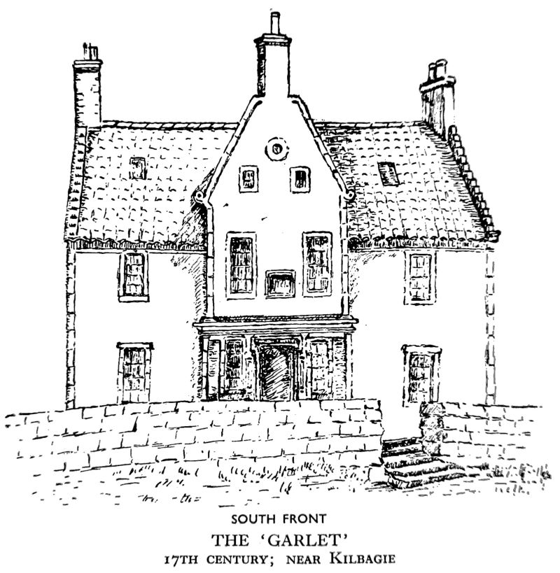
The first floor, now entered from the back of the house, contains three rooms, the central one being the former staircase landing. The original west room, 14 ft. 3 in. by 11 ft. has panelled walls, but the panelling appears to be of a later date than the house and is not well arranged. The panels formed by plain bands of wood are now covered with wallpaper and the wood was painted an unattractive shade of grey. This type of wall decoration was common in the first half of the 19th century. This was probably the withdrawing room of the house, the dining-room being below, with the kitchen on the opposite side of the lobby downstairs.
'The Manor House', Dollar. The original house was 38 ft. 9 in. by 19 and a half feet, two storeys and an attic in height. An addition was made at the west end, 40 ft. 3 in. by 19 and a half feet, one storey and an attic in height. The walls are of freestone rubble, harled grey and vary in thickness from 3 ft. 2 in. at the east gable to 2 ft. 5 in. near the entrance in the south front. The dressings of the voids are white-washed and the roof covered with red pantiles. The entrance was only 6 ft. high by 2 ft. 10 in. wide and the window openings 3 ft. by 2 ft. on the ground floor, and 2 ft. 10 and a half inches by 2 ft. on the upper floor. The house is undated but appears to be later 17th century, according to the style.
The arrangement and size of the interior in the original house were similar to the Garlet. A recess for two box-beds was provided in one apartment, originally concealed by panelled wooden doors. The addition to the house contained a kitchen, with a recess for a box-bed, and a storeroom. Recesses for box-beds were often contrived by making use of the triangular space beneath a straight staircase, later this was used for a cupboard.
No. 25 Kirkgate, Alloa, the town house of a master mason, Tobias Bauchop, is dated 1695. It measures about 40 and a half ft. by 34 ft. with walls about 2 ft. thick; it is two storeys and an attic in height. The south front is of finely pointed ashlar, not rubble; there is a cornice at the wall-head and rusticated quoins, the stones being grey and pale sand-coloured local freestone. The gables are crow-stepped with tabled skew-puts enriched by scroll ornament and a leaf design. The roof was covered with pantiles even towards the end of last century, but is now of grey slate. The voids of the south front are all enriched by delicately moulded architraves with lugs. There are simply moulded cornices above the ground floor voids, one of which has been enlarged; the plain window sills are well defined.
In the centre of the facade, at first floor level, is a projecting sundial, enriched with a carved floral design at the top and supported by a bracket carved to represent a grotesque human head. Below is a garlanded cartouche in the form of a shield, bearing the date 1695 and the initials of Tobias Bauchop and his wife. At the back of the house is a paved courtyard and the remains of a gateway.
Mansion-Houses dating from the first half of the 18th century and their Entrance Lodges and Stable Buildings.
They all have gardens, usually a walled garden and wooded parkland.
The mansion-houses include Brucefield, built c. 1724, for Alexander Bruce of Kennet, and Tullibody House, built between 1725 and 1743 by Mr Abercromby, who then owned the estate.
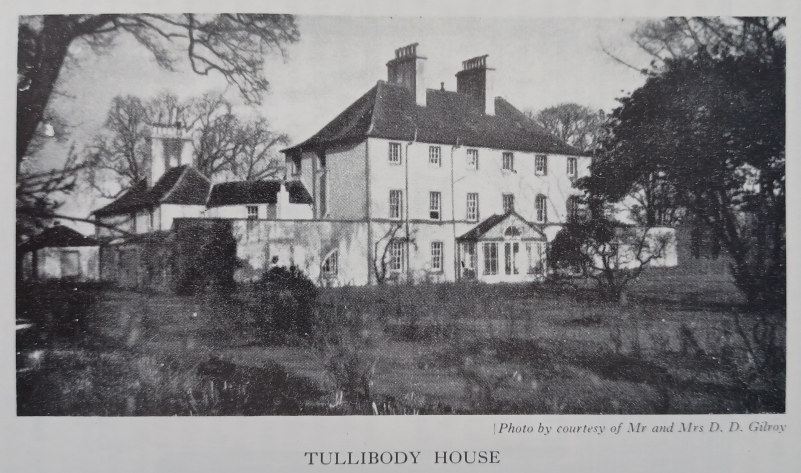
Brucefield was originally in the form of the letter H, but with very short uprights, represented by the two-storey wings, and the central block was three storeys in height. It was first built on a treeless moor which has become a beautiful park surrounded by woods. Tullibody is little changed and has a central rectangular block of three storeys joined to two rectangular wings of two storeys (placed at right angles to the original back wall of the main block) by curved, or segmental, portions. This enclosed a courtyard on three sides, which used to be at the back of the house but is now at the front. The original front, facing westwards, looked over the garden to the river Forth.
Both these houses have features in common, such as a steeply pitched slated roof, coursed freestone rubble walls (still harled at Tullibody, now exposed at Brucefield, which has been restored), a pillared outside porch sheltering the principal entrance. Tullibody has a graceful bell-cast to the roof and moulded string courses to relieve the plainness of the harled walls. The proportions of the window openings in the facade of both houses is pleasing; those at Brucefield* vary in length, at ground floor level they are 4 and a half feet by 3 ft., on the first floor 6 ft. 3 in. by 3 ft., on the second floor 4 ft. 9 in. by 3 ft.; those at Tullibody are 6 ft. by 3 ft. on both the ground and first floors, and on the second floor 4 ft. by 3 ft. This variety in length gives character to the plain style of the facade.
* The approximate dates of the two mansion-houses are given in Scotland and Scotsmen in the Eighteenth Century, from the Ochtertyre MSS, 2 vols., vol. ii (Blackwood, 1888).
The tendency to conceal the roof and chimney-stacks as much as possible by constructing a hipped, or piended roof and surrounding it, at least above the facade, with a balustrade, or parapet, did not come into fashion in the county until the second half of the 18th century, as the classical revival style became more common. It is interesting to notice how roofs gradually became lower during the later 18th century and the Scottish high-pitched roof was built only on small houses, cottages and farm buildings.
The interior of Brucefield is modern, although the arrangement of the rooms follows to some extent the original plan of the 18th century. One staircase of stone, of circular type, and a fireplace are probably of earlier date. The interior of Tullibody is very little altered. One ground floor room, on the north side of the entrance hall, has been made into a bathroom in the later 19th century. The woodwork throughout the house shows the careful treatment of the 18th century and that of the two large public rooms, dining-room and drawing-room, is suitably enriched with panelling and carved ornament on the chimney-piece and over the doors. There are two pieces of attractive wrought iron ornament on the balustrade of the staircase in the main block.
The arrangement of the rooms at Tullibody in relation to each other is good for the period. Passages, a new convenience in interiors, connect the main block and the wings on the ground and first floors. There are three staircases. The dining-room, on the first floor of the main block, is placed next the wing containing the kitchen and offces and connected with them by a short staircase. The servants' bedrooms are on the upper floor of the two storey wing and not on the attic floor, as was often the case. There is no basement. All these arrangements indicate the advance in the planning of interiors towards comfort and convenience.
Stable buildings, situated near the mansion-house, were usually planned in the same style. Those at Tullibody are close to the servants' quarters in the north wing. At Brucefield, the stables are farther away from the house, and are situated on one side of the private road leading to the avenue. The stables are symmetrical on plan, the buildings occupying four sides of a rectangular inside courtyard. The elevation is picturesque in outline, with pantiled roofs and a tower on the south side showing Dutch influence. The upper floor of the stables is used for dwellings.
The Dower House of Dollarfield, Lower Mains of Dollar (ruined). This smaller mansion is an example of a laird's house of the early 18th century, set in a moderate sized garden, with picturesque stable buildings nearby and a group of old cottages behind, probably the dwellings of estate employees. The house is two storeys and an attic in height and measures about 31 and a half ft. by 18 and a half ft.; it faces south. East of the central entrance the front was bow-shaped and there was a projecting round in the centre of the back wall to contain the circular stone staircase. The walls of freestone rubble varied in thickness from 1 ft. 11 in. at the entrance to 2 ft. 2 in. at the back. The dressings of the voids are of grey freestone and the window sills very pronounced. The high pitched roof was covered with grey slates. The quaint outside porch of stone with four pillars, now destroyed, had a carved entablature with a broken pediment of Baroque style. The only chimney-stack, in which four flues found egress, rises from the east gable and the absence of a corresponding chimney in the west gable is unusual and has a curious effect.
Mansion-Houses of the second half of the 18th century, Entrance Lodges and Stable Buildings.
There are many examples of this period in the county:
Kennetpans House has a fine situation, set in gardens and orchards, close to the river Forth. It is now only partly inhabited. The mansion was originally rectangular on plan, with a small ornamental central gable, harled walls, a low pitched roof of slates and rather small window openings. It was three storeys in height and the ceilings of the rooms were lower than in later mansion-houses. In the early 19th century a two-storeyed west wing with a bow front was added. This provided a fine large dining-room, curved at one end and lighted by a Palladian window and others, with a floor shaped like the deck of a ship, and above it on the first floor, a large drawing-room with a high ceiling enriched with a moulded plaster medallion in the centre and a decorated cornice.
Kennet House, finished in the last decade of the 18th century, was designed by a Mr Harrison, a Lancaster architect, but the mansion resembles the work of the Adam Brothers. The facade of Kennet is of grey freestone ashlar and two storeys in height viewed from the entrance, but there is a sunk basement which forms the ground floor, looking over the garden at the back as the ground falls below the level of the avenues there.
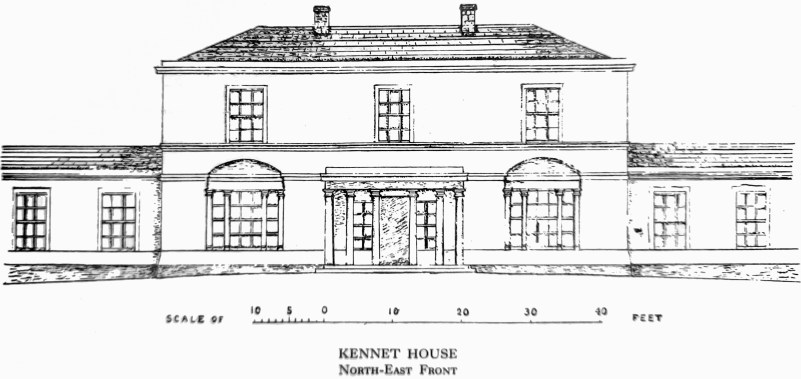
The main block, covered by a low, piended or hipped slated roof, measures about 68 and a half ft. by 55 and a half ft. and there is a two-storeyed wing, including the basement at each side, with both a narrower and a wider portion, viewed from the front, owing to later additions, such as the 'Burleigh Wing', added in the second half of the 19th century.
The entrance hall and all the numerous apartments have carefully treated woodwork, enriched by panels, mouldings and scenes, or groups of figures, floral motifs, urns, etc. The carved wooden mantelpieces are interesting, but tend to be over-decorated; the mantelshelves are unusually high. The designs used are certainly inspired by the decorative work of the Adam Brothers and have been attributed to them, but are not among their best productions.
The Stables of Kennet House have a severely classical revival facade and are planned to occupy the sides of a rectangular paved courtyard. The small octagonal tower, designed as a dovecot, rises from the back range and is an attractive feature, relieving the severity of plain horizontal lines. The lodge at the entrance gateway is ovoid on plan and of one storey and an attic.
Alva House, now a ruin, used to consist only of the east wing of the mansion of the Johnstone period, which stood from 1789 until the west wing was added in the earlier 19th century. The principal entrance of the original house was in the west front. John Johnstone, Esq., became a client of the Adam Brothers in 1789* and they designed additions and alterations, including the present, ruined, south front, with central triangular pediment, balustrade (hiding the roof and chimney-stacks), with urns at the angles and a Palladian window at first floor level above the central entrance. The west wing was also built by Mr Johnstone. The latter was enjoying a considerable fortune made in India as a younger man.
* A. T. Bolton, The Architecture of Robert and James Adam, vol. ii,; Index of Adam's Drawings, vol. 34. Soane Museum, London - the Adam Brothers intended the facade to have a rusticated ground floor and two Ionic upper floors.
The Adam Brothers designed the very attractive stable buildings west of the mansion in 1789 and the east and west gateways and lodges; that of the west gate is planned so that the kitchen-living-room is on one side of the gateway and a second room on the other side. Convenience and comfort are here sacrificed to symmetry and exterior design, as was then the fashion. These buildings can still be seen.
Tillicoultry House was built on a quadrilateral plan with a pillared outside porch of stone, wrought iron balconies at each first floor window, a very low hipped roof and short chimney-stacks which was fashionable when the mansion was built in the later 18th and first decade of the 19th century. The drawing-room on the first floor had walls with large panels above the moulded chair-rail, and the centre part of each panel was covered with wall-paper. There was carefully treated and enriched woodwork and a carved, white marble, chimney-piece, decorated in the Adam style, with statuettes in high relief on the jambs.
The stable buildings were arranged on the four sides of a rectangular courtyard and the west faqade enriched in the early 19th century, classical revival style. There is an ornamental clock turret over the central entrance, which lends character to an otherwise attractive elevation and resembles similar turrets in the Low Countries, Denmark, etc.
In the walled garden behind the stables is a circular pillared summer-house of wood in the classical revival temple style. It is very carefully made inside of short pieces of narrow boarding, arranged diagonally to form a polygonal back wall.
Harviestoun Castle was originally an 18th century mansion of classical revival type, but it was altered in the first quarter of the 19th century by Mr Tait. The style is now revived Scottish Baronial. The walls are of red freestone and the castle is a very handsome building enriched with angle towers and crenellated battlements. In the interior the enriched woodwork and the oval drawing-room, in the west wing, with a beautiful hand-painted ceiling, in pastel colours, are the chief features of interest of that period. Further additions were made, including the handsome library and the rectangular tower c. 1870. The stable and farm buildings behind the house are in the classical revival style.
Hillfoot House has been much altered and enlarged. There still remain a few 18th century portions. The interior woodwork and its enrichment is the most interesting feature of the mansion. The stable buildings near the house are symmetrical on plan and in elevation and of classical revival style.
Alloa House. The mansion which used to be attached to the east side of the Tower was burnt down for the second time in 1800. The later house was constructed to the east of the Tower and some distance from it, in 1830-32. It was a severely plain box-like mansion with a parapet concealing the low roof and almost the whole of the chimney-stacks from view. The stables were in the same style and attached to the north-west angle of the house. In 1868 the present exterior, with wings higher than the main block, was built, and the stable buildings became part of the mansion-house. Stables, on a symmetrical plan with an inside courtyard, were built near the Tower in 1852.
Schaw Park, now roofless, was originally built in the 18th century, but has been altered. It has ornamental battlements and a Moorish type of moulding on the window dressings, which, possibly, were designed by the Adam Brothers, as Lord Charles Cathcart, the proprietor, was their client from 1775 until his death the following year. Oriental enrichments were fashionable, but Lord Cathcart was for many years British Ambassador to the Russian Court and probably suggested the style.
IV. SMALLER HOUSES AND OTHER STRUCTURES
MANSES
Clackmannan Manse was built in 1740, but additions have been made and bow windows thrown out on the western half of the south front and dormer windows constructed to light the second, or attic, floor. A beautiful site for the manse was chosen east-south-east from the church, on the southern slope of King's Seat, with a lovely prospect over lower flat ground to the river Forth. It is built of freestone rubble and the roof covered with slates. It was originally rectangular on plan and of moderate size. The original dining-room was provided with a recess for the sideboard in the curved north-end wall. There is a carved wooden mantelpiece, decorated after the Adam style and in very good taste. The public room immediately above, on the first floor, has also a carved wooden mantelpiece of similar style. They may have been Adam's work, but possibly a design was supplied by the architects and carried out by a craftsman in the district. There are stables and outhouses at the back, a walled garden, extensive grounds and a glebe.
Tillicoultry Manse. There have been at least three manses, the earliest would be near the old church at the back of Tillicoultry House. The present one is the second on, or near, the site, beside the church of St. Serf and was built in 1811. It is 39 ft. by 33 ft. 2 and a half inches, two storeys and an attic in height, with walls 2 ft. 3 in. thick, built of freestone rubble and roofed with slates; it faces west and has a walled garden, across the drive which is at right angles to the main axis of the house. The church and manse are set in the same grounds, planted with shrubs and trees.
The public room on the north side of the entrance hall measured 14 ft. 9 in. by 13 ft. 2 in., including the curve of the east end wall, the curve being 2 ft. 10 in. in depth. It was lighted by a moderate sized west window. The woodwork was nicely panelled and the plaster ceiling cornice fluted.
The public room on the south side of the hall measured 17 and a half ft. by 13 ft. 5 in. It also had carefully treated panelled woodwork and was originally lighted by two windows looking south and west, a bay window had been added on the west side. The wooden mantelpiece was enriched with carved flutes.
Another public room in the south-east portion of the house measured 12 ft. 7and a half in. by 10 ft. 4 in. and had a panelled and fluted wooden mantelpiece in the centre of the south wall, with a narrow panelled wall-cupboard door on either side. There was a chair rail and one window with panelled shutters looking west. The ceilings were all of quite a good height and the inside partitions, or walls, between the rooms 1 ft. 2 and a half in. thick.
The staircase curved upwards from the inner east end of the hall; the edge of the upper, wooden landing-floor over the staircase was decorated with seven flutes and a hollow.
The bedroom on the first floor, above the dining-room, had a dressing-room opening off the north wall. The room measured 10 ft. 11 in. by 13 ft. 8 in. The woodwork and mantelpiece were carefully treated and panelled. The ceilings were all quite high.
These measurements and the height of the ceilings show a marked improvement in the dimensions of manses by the early 19th century. There are no examples of 17th, or very early 18th century manses in the present county of Clackmannan, but a few measurements of the old manse (1698) are quoted in the Records of Logie Parish of which the eastern part formerly was in the county. This gives some idea of the poor house it must have been, with very small rooms and ceilings between 6 and 8 ft. high. The manse built in 1698 was only 15 and a quarter ft. broad, the ground floor 6 ft. 7and a half in. high and the only upper floor 7 ft. 8 in. high. The fact that the upper was higher than the ground floor means that there would probably be no flat plaster ceiling(s) there, but just the open timber roof covered outside by pantiles. The cost of building this manse was 1800 merks.* The minister, Alexander Douglas, was 400 merks out of pocket and the heritors were supposed to pay the remainder.**
* A merk was equivalent of 13s 4d. Scots and about 1s. 1d. Sterling.
** Records of Stirling and Dunblane Presbytery under dates 23rd July 1693; 'The Book of Discipline of the Presbyterie of Dunblane, since their Disjuction from the Presbytery of Stirling, Begun 26 Apryle 1698', under dates September or October 1701; 6th August 1805.
On 6th August 1805 a new manse, replacing that of 1698, was finished, the total cost being £722 17s. 4d. William Stirling of Dunblane was the architect and builder. Sir Robert Abercromby of Airthrey gave a field, known as Jock's Croft, to be used as the site of the new manse and glebe. Mr Clason, the minister, chose half an acre within the field as the site.
Dollar Manse. The old manse, built in 1795 and enlarged in 1817, is situated east of the ruined 17th century church. It is still used as the manse.
Alloa Manse. The old manse dates from the 18th century and is no longer the manse of St. Mungo's Church. It has been altered and enlarged.
Clackmannan House. This is a house of moderate size, two storeys and an attic in height, situated to the south of Clackmannan village and the high road to Kincardine-on-Forth. It was built in the early 19th century style found in houses of similar size in Kincardine-on-Forth and Dollar. It stands in grounds of over an acre in extent, planted with trees and shrubs.
FARM-HOUSES AND BUILDINGS
Balquharn Farm-house (probably once the laird's house). This, in origin, is one of the oldest farm-houses in the county. The original rectangular house measured 36 ft. 10 in. by 23 ft. 9 and a half in. a rectangular projection at the centre of the back north wall contains the circular stone staircase, with a newel, but the upper part of the stair is of wood. The house is two storeys and an attic in height, the walls being of freestone rubble and the south front wall 3 ft. 2 in. thick, while the north wall was 2 ft. 5 in. thick and is now an inside partition. The principal entrance has a massive oak door, 6 ft. 4 in. by 3 ft. 3 in. The height of the ground door ceilings is only 7 ft. 7 in. A new east wing was added to the house.
The roof is now covered with slates, instead of pantiles, and a bow window has been thrown out. The lands of Balquharn (Balecharn or Balecharun, etc.) are mentioned in a charter of King Robert the Bruce, along with the lands of Sauchie (Salacketh or Salchay or Salachothe, etc.) in the territory of Menstrie (Mestry) and the shire, firstly of Stirling* and secondly of Clackmannan.**
The farms in the county were all small in the early 19th century, the average size being about 40 Scotch acres, or almost 50 English acres. Farms in the Carse of Stirling were from 30 to 80 Scotch acres.***
* Reg. Mag. Sig. Regum. Scotorum.
** Reg. Mag. Sig. Regum. Scotorum, dated at Peyblis (Peebles), 10th June 1324.
*** John F. Erskine, Esq., of Mar, A General View of the Agriculture of the County of Clackmannan.
Dams Farm-house. This smaller farm-house is situated west of Balquharn and its style is typical of the late 17th or early 18th century farm-house with harled walls, small voids and low ceilings. It used to be roofed with pantiles, but these have been replaced by slates. There is a picturesque pantiled barn at the back of the house on the opposite side of the farm-yard, which has buildings on all sides, the house being on the south.
King-o'-Muirs Farm-house. It was built, probably, in the later 18th century. The older farm-house, associated with James V, when he wandered about, incognito, as the Guidman of Ballingeich, on Tullibody Muir, and elsewhere, was on another site, in a small wood to the south-west.
This 18th century house faces east, having the small garden in front and the farm-steading behind, built round the other three sides of a rectangular yard. There is a D-shaped public room on the first floor, looking east, which is the drawing-room; the three-light window follows the curve of the wall. The woodwork has been carefully treated and panelled. The back door has now become the principal entrance. The walls are harled and cream-washed, the roof covered with grey slates; the house is two storeys and an attic in height.
Lornshill Farm-house. This house is similar in size and style to King-o'-Muirs and is probably late 18th century. It has bow windows on both floors on each side of the central entrance. It faces east and the small garden is in front of the house and the farm-steading at the back.
Farm buildings in the county improved in construction from c. 1760.* There are a great many two-storeyed farmhouses of varying size in the county, which were originally built of freestone rubble and harled, in the later 17th and throughout the 18th centuries. They originally had pantiled roofs, like the farm buildings, which still, to a large extent, are roofed with tiles. The farm-houses have moderate to high-pitched roofs, except one or two examples situated west of Tullibody village, which are low-pitched, and they are all now covered with grey slates. The house always occupied the whole of one side of the farm-yard and the large barn another side, while outbuildings ran along the other two sides. Sometimes recesses for box-beds and salt-boxes were provided in the living-room-kitchen, and recesses for the former are also found in first floor rooms.
* John F. Erskine, Esq., of Mar, A General View of the Agriculture of the County of Clackmannan.
Red Yett Farm-house is of one storey and an attic and has these recesses.
Jellyholm Farm, not far from the west end of Gartmorn Dam, was farmed 150 years ago by a French family from Normandy. Local tradition derives the name from 'joli homme' or 'home'. Holm means oak-tree, however. Auchinbaird, west-south-west of Fishcross village, now a ruin, was inhabited until a few years ago. It was one of the oldest smaller farm-houses of one storey in the county. The roof timbers of oak were massive and very little dressed and the roof was still covered with pantiles like the picturesque low farm buildings.
Parkhead farm-steading has a very attractive old barn, built of freestone rubble and roofed with pantiles. On the south side there are a series of round-headed arches at ground floor level, for the reception of carts, and they are so well-proportioned that they provide an enrichment.
East of Brucefield mansion-house is a picturesque group of buildings, with harled whitewashed walls and red pantiled roofs, set in a wooded landscape. There is a one-storeyed farm-house with a steading and down by a stream is an old mill driven by the Bluther Burn.
Mills. There are a number of old mills in the county associated with villages and towns, castles and medieval religious foundations. Many of them like that at Brucefield, Linn Mill and Forestmill on the Black Devon, and the mill north-west of Cambus village could form attractive subjects for a water-colour sketch.
Doocots.
Doocots often are incorporated in the stable buildings of mansion-houses in Clackmannanshire, and provide one of the most attractive features of a facade, as they form the stable turret, or tower, rising from the roof, e.g. Bruccfield, Kennet and Alva House Stables.
There is a Dovecot at New Mills Crossing, on the left bank of the river Devon, 700 yds. south-south-east of the Old Bridge of Tullibody at Bridgend. It is rectangular on plan and probably of 18th century date. It measures 19 and a quarter feet by 17 and a quarter feet externally. The walls are of harled rubble. There is one string course. The flanks are crow-stepped, the upper part being stepped to receive an 'upstand' in the roof, in which are entrances for doves. The entrance facing south-east has an iron-studded door.
There is also a Dovecot at Kilbagie. At each of the two western angles of the wall surrounding the Forth Paper Mills, formerly the site of the 18th century distillery, are two ruinous circular towers, the southern of which is provided with nests for doves. On the lintel over the entrance are initials and the date 1859. The small number of dovecots in Clackmannanshire is a contrast to Fife, which is remarkable for its many dovecots, which are separate buildings. By the end of the 18th century there were 360 doocots in that county.*
* Rev. J. Thomson, Survey of Agriculture of the County of Fife (Edinburgh,1800).
V. ROADS AND BRIDGES
ROADS
The map by James Stobie, dated 26th May 1783, about twelve main roads in and running through Clackmannanshire. From about the year 1720 to 1725, roads began to be shown on maps, which became larger during the 18th century.
The Turnpike Acts were passed at intervals in the same century; commissioners in each county were authorised to construct and improve roads and to levy tolls for their upkeep at turnpike gates.
The old highroad, with a gravel bottom, which ran along the foot of the Ochil Hills from Causewayhead to Muckhart and Crook of Devon (river), via Dollar village and the Hillfoots towns, Alva and Tillicoultry, and villages, Menstrie and Blairlogie (East Stirlingshire). It still partly remains and is used a little for occasional light traffc to farms, mansion-houses and villages.
From the medieval period, the kings of Scotland and ordinary folk used this road, when travelling from Stirling to Falkland Palace and the inland parts of Fife. This road went to Kinross, on the shore of Loch Leven, etc., and a branch led up Glen Devon and doun Gleneagles to Perth. In 1798 Thomas Garnett, M.D., a Professor in Glasgow University, found the highroad in very good condition. It was, however, too narrow for two vehicles to pass each other without difficulty. At gates (turnpikes) tolls and duties were demanded from vehicles, horsemen and cattle drovers.
There was also a highroad from Stirling to Alloa, Clackmannan, Culross and the towns on the north shore of the Firth of Forth, with a road running inland to Dunfermline.
A short road led from Menstrie to Tullibody Village, where there was a cross-roads, that running south and east led to Cambus village at the mouth of the Devon and to Alloa, the other two roads led to Causewayhead and Alloa respectively. These are all still main roads.
To the north of Tullibody village a road ran part of the way due east from the above-mentioned Menstrie road, along the south side of the Devon valley, via Fishcross, Coalsnaughton and Dollarbeg to Blairingone and Powmill and also to Solsgirth and Saline. This road was not gravelled in 1795 when the Old Statistical Account was published.
Alva village had no public road running south bv Fishcross to Alloa in the earlier 18th century, but the avenues of approach to Sauchie Tower and the 17th century mansion-house ran north and south to join the highroads on each side of the Devon valley. When the Schaws removed to their new mansion-house of Schaw Park the avenues became a public road, but it was in bad condition for a time.
There was a road running south from the Hillfoots highroad to Coalsnaughton, west of Tillicoultry Parish Church, and another road from Westertown down the burn and up the hill to Fishcross and so to Alloa. By 1841 materials for repairing roads were abundant. The turnpike road to Alloa was good and also those to Stirling, westwards, and Kinross, eastwards.
A road ran north from the old Hillfoots highroad, going through Old Dollar village up the western side of Dollar Glen to Castle Campbell, with a branch leading through a pass in a north-easterly direction to Glen Devon by Glenquey.
A road leading southwards and eastwards from Dollar village ran to a cross-roads near the Mill of Muckhart, from which there was access to the Hillfoots highroad, Caldron Linn, Solsgirth House and Fife.
A road ran from Blairingone to Clackmannan burgh via Allaleckie and Forestmill village, where a school was opened by 1703; at Allaleckie there was also a school from the first decade of the 18th century. Clackmannan Parish Church subsidised schools at these places and also in Sauchie and Clackmannan itself.
The former boundary of the county was farther west and thus included the village and Abbey of Cambuskenneth in Clackmannanshire, so that the Causewayhead cross-roads was close to the western county boundary. The road from Alloa to Stirling and to Bridge of Allan divided at this cross-roads as it does now. This road from Alloa passed through Craigmill village, situated at the southern base of the Abbey Craig; it used to be a centre for smugglers. By the later 18th century the four turnpike roads which met at Causewayhead went west and north to Crieff, east and south to Alloa, east and slightly north to Dollar, etc., and south across the Old Bridge of Stirling over the river Forth.
Before 1841, there was a post offce in Clackmannan burgh and the mail coach from North Queensferry to Alloa and Stirling passed through Clackmannan about 10 a.m. every day, while a travelling coach ran through the burgh every week day about 6 a.m. on the way to Alloa and Glasgow via Stirling. These highroads must have been in good condition.
The river Forth was a moving road and steam-boats sailed between Stirling and Newhaven and (or) Granton, calling at the river ports like Alloa and Clackmannan. The fares were small at that time.
In coaching days Kincardine-on-Forth, near the south-eastern county boundary, was one of the important centres of communication, by means of its ferry, between the southern boundary of Fife, which was the river Forth, and the south and west.
In an Act of 1802 regarding the making and repairing of the highroad from Causewayhead through the county by the Hillfoots and West Saline and Crossford to Queensferry and certain branch roads from this highroad, the following places were mentioned: Dollar village, Torryburn, Tillicoultry Gate (turnpike), Alloa, Kinross, Crook of Devon, and the parishes of Logie, Alva, Tillicoultry, Dollar, Saline, Carnock, Dunfermline, Clackmannan, Alloa, Muckhart, Fossaway. In 1805 the former entry into the Crofts of Alva became part of the new main road from Stirling, known as the Toll Road.
From the later 18th century seven roads radiated from the town of Alloa in all directions. There were three roads leading to Stirling, one running north-north-west out of the town, one going almost due north from the then new Alloa Academy (school), with a branch going to Ludgate Toll, a third road running up Mar Street to the crossroads at the old Tontine Inn and continuing northwards. A road went to Dollar via Shilling Hill, Newtown of Sauchie and the south side of the Devon valley. Another left by Shilling Hill going to Clackmannan, Kincardine-on-Forth, etc., Culross and Fife coast. A road named John Street, later Broad Street, ran south from Alloa to the harbour. A secondary road ran north and west to the glass, tile, lime and brick works and on to Craigward Ferry and also to a quarry north-east of the ferry pier.
BRIDGES
Bridges were built near, or over, old fords over streams.
In the Hillfoots district, in the county, there are several old bridges in villages and towns, which carried the old highroad over the streams running down the southern slopes of the Ochil Hills through glens. There was a hump-backed bridge in the old town of Alloa that carried the main street over the Brathy Burn; its existence is commemorated in Bridge Street.
Mary Bridge, on the site of Queen Mary's 16th century bridge, carries the modern main road from Alloa to Dunfermline over the Black Devon, north-west of Clackmannan burgh and only a few yards from Tower Inn. A disposition of Robert Bruce of Clackmannan, dated 6th July 1642 mentions this bridge as 'St. Mary's
Brig'. *
* T. Crouther Gordon, The History of Clackmannan.
Tullibody Bridge carries the road from Menstrie to Tullibody over the Devon, half a mile north of Tullibody village. It crosses the river in two segmental arches. Above the central cut-water on the west side is a 17th century blazon bearing helm and mantling and a shield parted per pale: dexter, a chevron between three boars' heads erased, for Abercromby; sinister, a fess between three (?) boars' heads erased, for Gordon. The width between the parapets is 10 and three-quarter feet.
The Old Bridge, Bridgend, now unused, protected by the Ancient and Historical Monuments Acts, once carried the main road, over the Devon, from Tullibody to Causewayhead. It is situated one mile west of the old village of Tullibody, where the river is about fifty feet wide. It also carried the traffic of the present main road from Alloa to Stirling, via Causewayhead, until the 20th century bridge was constructed. The Old Bridge extends west to cover any possible flooding, thus measuring 442 ft. along the parapets.
The roadway is hog-backed and unusually winding, varying from 11 and a half feet to 20 in width. The parapet is about 5 ft. 4 in. high.
According to the Acts of the Scottish Parliament this Old Bridge was described as the only passage over the river Devon, in winter, from Stirlingshire, etc., in the west to the Sheriffdoms of Clackmannan and Fife, or, conversely, the only road from Alloway (Alloa) and Clackmannan etc. to Stirling, Glasgow and the west.
On 23rd January 1560, when the French troops were retiring from Fife towards Stirling, 'William Kirkcaldie (of Grange) cutt the Brig of Tullibodye',* but the French removed the roof of the parish kirk and made a bridge for their soldiers with the material.
The Town Council of Stirling took a special interest in the upkeep of this bridge. References to the repair of this bridge may be seen in the Records of Stirling burgh in the years 1600, 1616, 1663, 1665, and 1681.**
* John Knox, Historie of the Reformatioun, ed. 1732.
** Extracts from the Records of the Burgh of Stirling, p. 96, also p. 249. Reg. Pr. Co., x., p. 555 ; Acts Parl. Scot., viii, p. 364.
The bridge over the river Devon carrying the road from the Hillfoots highroad to Coalsnaughton. This connected the latter with the two other villages in Tillicoultry Parish, viz. at the foot of Tillicoultry Glen and Eastertown, or Earlstown, which stood near the west end of Harviestoun Castle, until the end of the 18th or early 19th century, when Mr Crauford Tate had it removed.
Below the present Tillicoultry village (Westertown in origin) there was a wooden bridge for pedestrians over the Devon. In c. 1820, Tillicoultry Bridge over the Devon was widened.
At Dollar village there was a good stone bridge over the stream from the glen, nearly opposite the old parish church, now ruined, but it was carried away by a flood. About 1795 a wooden bridge was erected by public subscription to replace it There was also a bridge over the river Devon, south of Dollar village, to carry the road from Dollar to Solsgirth, and Saline in Fife, etc., and also to Forest Mill, Clackmannan and Kincardine-on-Forth.
Vicar's Bridge, over the river Devon, south east of Dollar village, was so named after Dean Thomas Forrest, Vicar of Dollar, accused of heresy in 1538 and burnt at the stake in Edinburgh. It carried a road from the Hillfoots highroad to another main road running between Clackmannan burgh and Powmill, via Forest Mill and Blairingone. The present bridge is not the original structure, except part of the foundations.