
Below is a list of Collieries/mines/pits/shafts which at one time operated in Clackmannanshire. Many of the pits listed below have since been filled in / capped / remediated in some way.
This page, like most others here on Clackmannanshire.Scot, is very much subject to review and revision, as further or more accurate information becomes available, including locations, operating dates, and working practices.
We will try to locate all of the Clackmannanshire pits, and possibly, date them and chart them on a map.
If you know anything about Clackmannanshire's mines or can help with the workings listed or indeed not listed below, please get in touch.
Mining
The first authentic accounts we have of coal being wrought in Scotland, was in the lands belonging to the Abbey of Dunfermline, in the year 1291. The first pit in Clackmannanshire was reputedly opened at Alloa in 1519, and pits at Kennetpans are recorded as supplying coal for extraction of salt from sea-water. Machines used for draining the pits were first recorded around 1600, and further pits are recorded as having been opened at Alloa and Sauchie around 1603.
Mines - Coal
Alloa
Alloa Colliery : Mitchell and Company {1854}, Alloa Coal Co. {1893}, Alloa Coal Co. {1908}
8 March 1823
On Saturday last, about six in the morning, as one of the men belonging to Alloa colliery was engaged in hooking on a basket at the pit mouth, while the regular banksman had gone to give the engine a fire, he rather incautiously brought the basket on the shutter, and, instead of going smoothly out the wheels of the basket, it caught the point of the shutter and forced it back, when, dreadful to relate, the whole were precipitated into the yawning chasm, a depth of nearly 48 fathoms, which proved fatal to the poor man. He was only 21 years of age, and has left a wife and three children to deplore his premature and melancholy fate. It is singular that scarcely a blemish was to be seen on his body, the head excepted, which was shockingly shattered. Caledonian Mercury.
17 November 1845
We regret to state that, on Monday last, a woman, belonging to Alloa Colliery, was killed in one of the coal pits, by part of the roof falling on her, which crushed her so that she immediately expired. Her husband was working in the pit at the time, and she had gone in for the purpose of delivering to him some communication. Glasgow Herald.
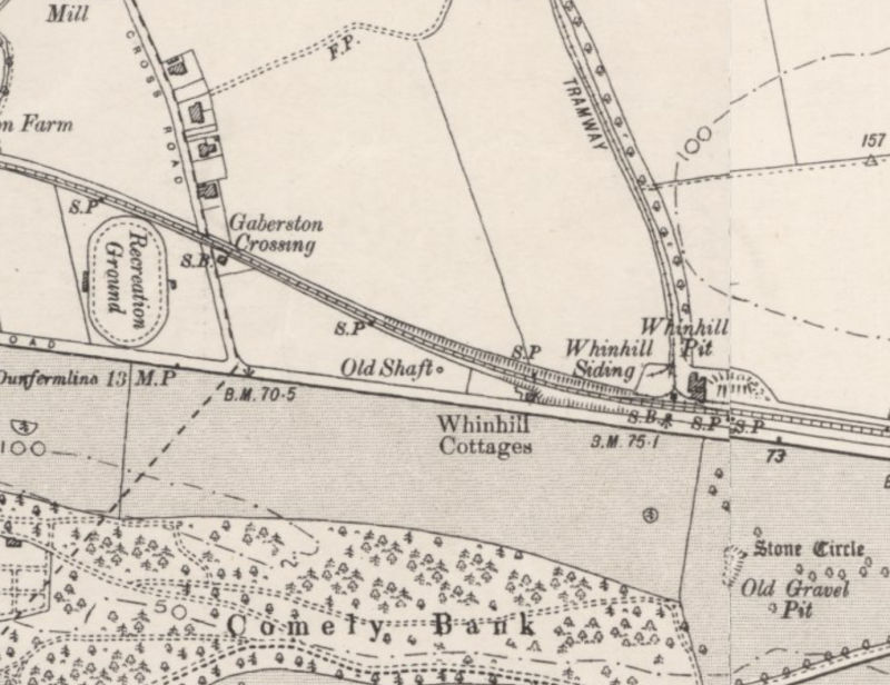
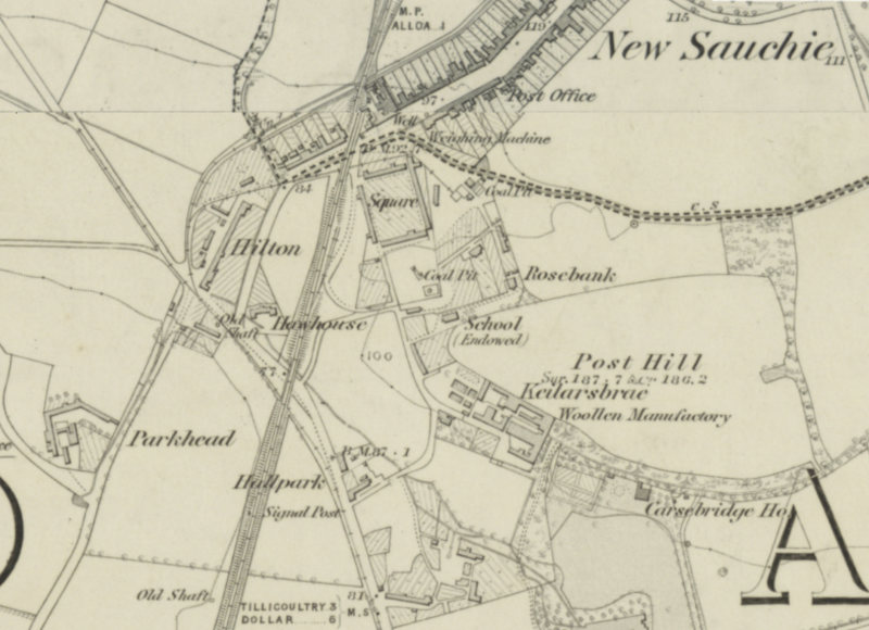
Alloa, Whinhall Pit No. 1 - Started 1873. Closed 1936. - Alloa Coal Company. Sometimes known as Whinhill pit (as in the OS map Below), it was located near the Alloa to Clackmannan stretch of the Stirling and Dunfermline Railway, at the north side of the tracks where the Morrisons roundabout currently sits. There is currently a pond nearby which was created by mining subsidence and flooding.
2025 : The area has recently been cleared of trees and the elevated pit bing and raised sidings area can be seen more clearly. The pond mentioned above has been excavated, presumably prior to development.
Alloa, Whinhall Pit No. 2 - Started ? Closed (before 1901). - Alloa Coal Company. Shown as 'old shaft' on the picture below, it was located roughly where the Alloa Fire Station now stands.
2 December 1922
A miner named David Hutton, residing at The Square, Clackmannan, was engaged on Saturday morning at his usual employment in the underground workings of Whinhall Pit, No. 2, belonging to the Alloa Coal Company (Ltd.), when a large stone fell from the roof, and killed him almost instantaneously. The deceased was about 30 years of ago, and unmarried.
Alloa, Whinhall Pit No. 3 - Started 1902. Closed 1919.
OS Map 1901
Jellyholm Colliery (Jellyholm pit) - Started 1887. Closed 1921. - Alloa Coal Company. Located near the west end of the Gartmorn Dam, this pit became unprofitable and was closed in 1921.
24 August 1861
On Friday forenoon, Andrew Hunter, a miner in the employment of the Alloa Coal Company, met with his death while working in No 1 pit, situated at New Sauchie. At the moment of the unfortunate accident, Hunter was employed blasting the coal, and part of the roof falling in, crushed him so severely that death ensued almost instantaneously. - On Friday afternoon, William Harrower, a miner, residing at Holton, New Sauchie, met with an accident while working in Jellyholm coal pit. Part of the roof fell upon him, whereby he was bruised on the thighs, feet, and head, but the injuries are believed not to be of a serious nature. Alloa Advertiser.
28 October 1861
On Monday morning, Joseph Patterson, aged twenty-two years, met with his death in No. 3 pit of the Alloa Coal Company, by the falling in upon him of part of the roof. A considerable time was unavoidably occupied in removing the load by which the unfortunate man was killed.
Brandyhill Pit {1852}
24 September 1852
On Friday morning a colliery accident which we regret to say was attended with fatal results to four persons, occurred at one of the Alloa Colliery Pits, well known by the name of Brandyhill pit. Nine persons were employed to remove a piece of waste to give air to another pit which was considered not in the least dangerous. The men, under the able management of one of the oversmen, Mr Joseph Sharp, commenced removing part of this waste, when all of a sudden the earth, stones etc., accompanied by a large quantity of water which they had no idea of being there, came down upon the unfortunate workmen, four of whom were carried away, while five escaped without injury. The oversman had only left the spot where the accident occurred a few minutes before. On learning what had occurred, he immediately proceeded to the manager, Mr Paton, who fortunately happened to be in the neighbourhood at the time. After being made aware of the accident, Mr Paton, accompanied by the oversman, Mr Joseph Sharp, went down the pit, and remained until about 8 o'clock, to render every assistance to recover the four unfortunate men; up to that hour only two bodies were got, and, when found were quite dead. In this instance we are glad to say no blame can be attached to either managers or oversmen. Clackmannanshire Advertiser.
(Names of dead from Inspector of Mines Report: Robert Mitchell, John Bain, William Paterson, Robert Hunter)
Crandra Pit - Open for a short time, a walled shaft remains, located in what is now Sunnyside Cemetery, Alloa. The pit existed prior to the land becoming a cemetery. Houses near the pit included Crandra Row at the Whins, since demolished.
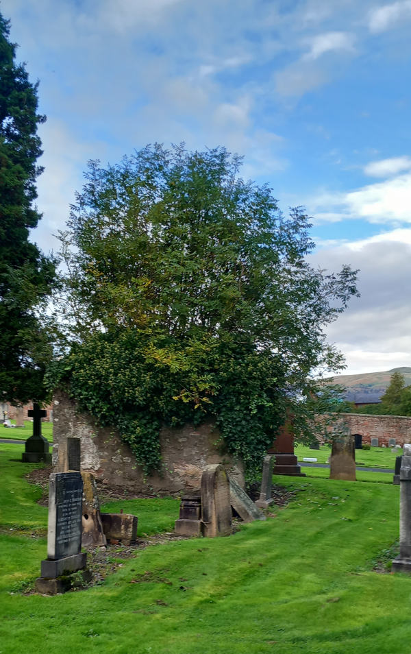
Crandra Pit shaft - walled off
Pic. - October 2023
Greyhound Pit No 1 and No. 2 - Located East of Hillpark
Old Mains Pit - Alloa Coal Co. (closed September 1886) Located East of Hillpark
Cauldhame Pit - East of Jellyholm Pit
Whinnyhall (closed sept 1883)
Broom Pit - Alloa Coal Co. {1873} Located on the site of the Hillton Fire Clay Brick and Tile works, on the side of the Brothie (Brathy) Burn to the south of Carsebridge Distillery.
It was connected via tramway to Whinhall Pit No.3.
Forthbank Colliery, Forthbank, Alloa 1892 - 1902, Alloa Coal Co.
Re-opened by NCB 1947, closed 1958. Located near to where the current council refuse collection depot now is.
Hillend Pit
11 July 1840
Melancholy Accident - Another coal pit accident occurred at Hillend colliery, near Alloa, on Saturday morning last, about four o'clock. One of the colliers, Joseph Cook, was preparing to descend the pit to commence his accustomed labour, when, on stepping into the tub, one of the eyes to which the hook is fastened gave way, and, lamentable to relate, he was precipitated to the bottom. When taken up, the body was found to be much mangled, and life quite extinct. Caledonian Mercury.
Alva
Alva coal mine: (Caroline Pit / Caroline Row Pit) (1860 to 1875)
Owned by James Johnstone, Alva mine was situated to the south of Alva on the northern bank of the river Devon. It was linked to a brick works on the southern edge of the village via a short waggonway.
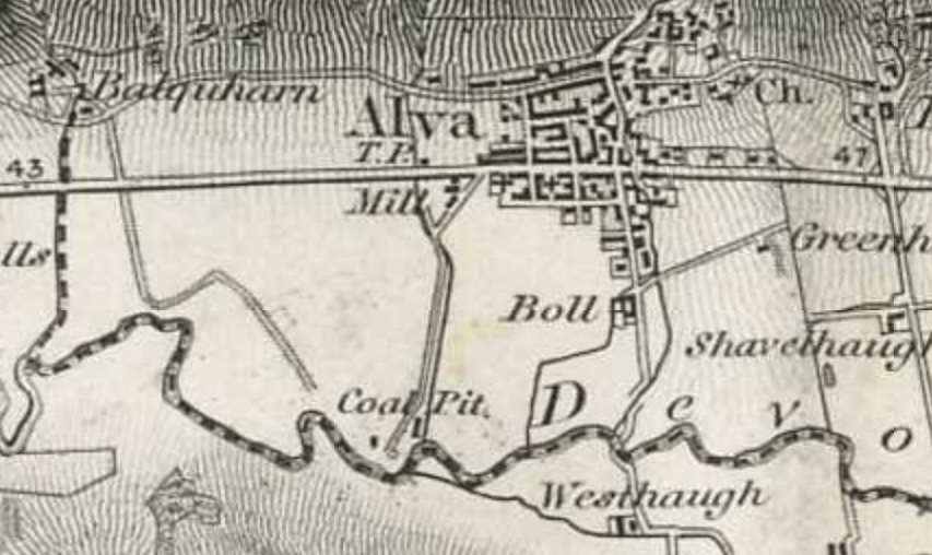
James is known to have owned the mine in 1860 and also other properties in the area. James donated Johnstone Park to the local people in 1856.
Alva No. 1 - 1872 Located immediately to the south of the Alva Railway Station site.
Alva No. 2 - 1873 Located at the Alva Burn at Brook Street (opposite the Boll Cottages).
Westhaugh shaft was located near to Westhaugh, just south of Alva.
Benview
Blackfaulds Pit - at the east end of Benview Terrace.
Willie's Pulpit pit - located on the south side of the road between Benview and Devonside.
Arns Well Pit
Whitelaws Pit
Cambus
Blackgrange No. 1 1889
Blackgrange No. 2 1902-1903
Haugh of Blackgrange No. 1 - 1889
Clackmannan
Clackmannan [Mitchell and Company] {1854}, [Mitchell and Moubray] {1866} [Clackmannan Coal Co] {1869}, (closed May 1878)
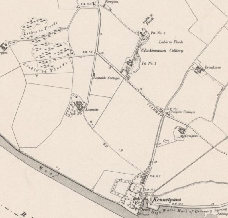
OS Map 1901
Clackmannan Pit No.1 and Pit No.2 were located beside each other on the carse south of Clackmannan near Ferryton to the north of Kennetpans.
24 November 1820
Accident At Clackmannan Colliery – On Friday last week, a boy, 12 years of age, while handing in pit wood into the bucket at the mouth of one of the above coal pits, lost his balance and fell down the pit, a depth of 23 fathoms. The unfortunate young man was found quite lifeless, with his neck dislocated, and his body shockingly mangled. This is the only instance of a life being lost at these works for the last forty years, although they are well known to be carried on to a great extent. Caledonian Mercury.
22 April 1856
On the afternoon of Tuesday last , an accident of a shocking description occurred at No. 1 pit of the Clackmannan Coal Company , situated on Hillend Farm, whereby Simon Cadzean, a collier, was killed. The deceased, who acted as bottomer in the pit, was in the act of being brought to the surface, after his day's work was over, in a cage, in the usual manner. Instead, however, of the engine being brought to a stand when the cage had reached the pit mouth, it was carried up towards the pulley-wheel in the frame above. Cadzean seeing this , must have at once apprehended danger, as he leaped from off the cage before reaching the wheel, on to the roof of a shed close to the mouth of the pit . So rapid was the ascent of the cage, however, that the deceased was ejected on to the roof, which being much sloped, Cadzean rolled off it right into the pit, and was precipitated to the bottom , a depth of about seventy fathoms! The poor man, in his descent , oscillated from side to side of the pit , and his body, in consequence, was frightfully mutilated. His head was terribly shattered, and all but severed from his body. - Alloa Advertiser.
Kerse Pit
21 January 1863
A fatal accident occurred at Clackmannan Colliery on Wednesday last, to a man named John Allan. He was at work in the Kerse Pit, when a heavy stone measuring upwards of six yards in length fell upon him, crushing him so severely as to kill him on the spot. A boy named Russell, who was at work close to the place where the accident occurred, gave the alarm, and the body of the unfortunate man was taken from beneath the superincumbent weight, and removed to his late residence. Allan leaves a wife and three children, the youngest only three months old. Dunfermline Saturday Press.
Clackmannan No. 14 - Clackmannan Coal Co. {1866} (closed October 1878)
Clackmannan No. 15 - Clackmannan Coal Co. {1866} (Closed November 1884) Located opposite Lady wood on the road out to Linn Mill.
Lady Wood Pit - Located at the bank of the Black Devon at the south side of the former Railway Viaduct.
Southfield 5 - Clackmannan Coal Co. {1873}
Clackmannan pit shown as in service 1893, Clackmannan Coal Co.
Old Mill Pit - located just east of Riccarton, Clackmannan
Craigrie - Opened 1852 [Devon Iron Company] {1854}, Tulligarth Coal Co. Ltd {1938} and {1939}, Alloa Coal Co. acquired the pit in 1942 and re-equipped it. NCB 1947 until the mine closed in 1952.
Craigrie Pit was located just across the road from Craigrie farm, to the immediate south of Clackmannan Tower. Minor remnants of the site - hard standing and low walls - still exist. the site is now used by the nearby farm for storage.
17 April 1852
Zetland Colliery (1935 to 1960) - Alloa Coal Co - 1935-1947. NCB - 1947-1960.
Zetland No. 1 and No. 2 - Located to the north of Helensfield on the north side of the A907.
Muir Pit - Located at what is now St. Serf's Roadin Clackmannan.
Tulligarth (Tullygarth) A.K.A. Pretoria Pit - Jas. Fyfe and Co. 1908, Tulligarth Coal Co. Ltd {1918 to 1941}, Alloa Coal Co. took over the pit in 1941, and was registered as still owning it in 1944 and 1945, Reported to have closed in 1944.
Tulligarth is located to the immediate east of the Cherryton brick works - the clay spoil from the mine was used to make the bricks.
25 February 1924
William M'Gough (32), a stone-miner, residing at The Square, Clackmannan , had a narrow escape on Friday night in the underground workings of Tullygarth Pit, While engaged brushing a road in the Hopehill section of the pit, a stone weighing 6 cwts. fell upon him from the roof. He was immediately rescued by some of his colleagues, but it was found that he had been seriously injured about the back and upper part of his body. He was removed to Alloa Hospital.
February 1925
While engaged in the underground workings at Tullygarth Colliery, near Clackmannan, an Alloa miner named Edward Young, 32, was knocked to the ground by a large stone from the roof. When assistance was forthcoming, it was found that the unfortunate man had been seriously injured about the lower part of the body. Dr Hetherington, Clackmannan, who was soon on the spot, ordered the man's removal to the County Accidents Hospital.
15 November 1932
Matthew M'Leod, Craigie Terrace, Clackmannan, was employed at a section in the underground workings of Tulligarth pit yesterday forenoon when a fall from the roof pinned him to the footway. When extricated he was found to be dead.
18 May 1938
James M'Lean (56) , Wester Craig, Clackmannan, a machineman at Tulligarth Colliery , near Clackmannan, which belongs to the Tullygarth Coal Company, was fatally injured yesterday when a stone weighing three tons fell on top of him. Death was instantaneous , his neck being fractured.
Tulligarth No. 1 - Tulligarth Coal Co. Ltd - Located East of Pretoria pit.
Tulligarth No. 3 - Tulligarth Coal Co. Ltd {1918} - work suspended September 1921. - Located east of Pretoria pit and south of Tulligarth No. 1, on the north side of the railway.
Tulligarth No. 4 - Tulligarth Coal Co. Ltd - Located just west of Forestmill Station.
Water-Mill Pit - Possibly located east of Heatherhouse (Clackmannan Pow) to the south of Clackmannan, 1740's, [Update] CFSS research puts this pit just east of the Craigrie pit location.
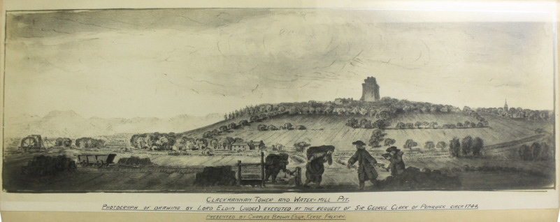
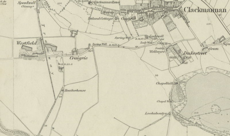
OS map 1843
Coalsnaughton
Sherrifyards Colliery - Sheriffyards No.1, 2 and 3 - Located at the east end of Gartmorn Dam - Opened by the Alloa Coal Co. in 1895, Closed 1921.
Garnstar (Ganister) [Probably Gartenstars pit, listed below][Alloa Coal Co] {1873}
Gartenstars Pit No. 1 and No. 2. Both of these are on the Gartenstars Plantation (a wooded area) between Coalsnaughton and Fishcross.
28 December 1870
A miner named Francis Hunter was on Tuesday afternoon working in Garnstone Pit near Fishcross, when a large quantity of debris fell from the facing, completely covering him. Notwithstanding the united exertions of his brother and some others of his fellow-workmen, who witnessed the occurrence, two hours elapsed ere he could be extricated, and he was then found to be dead. Glasgow Herald.
Gartmornhill No. 1 - Located at Gartmornhill Farm.
Gartmornhill No. 2 - Located to the west of No.1 pit.
Muircot No. 1 - Located at Muircot Farm.
Muircot No. 2 - Located at Drummie, Northeast of Coalsnaughton
Devonside
Devonside [Robert Bald] {1854}, [James Snowdone]{1860}
Woodlands Pit [Robert Bald] {1854} Located to the west of Devonside to the north of the A908.
Crankie Pit - Located at Ocilview, Devonside.
West Pit
11 March 1862
On Tuesday afternoon, an accident, which resulted in the loss of two lives, and by which several others were endangered, occurred in the coal pit at Devonside, near Tillicoultry, known as the west pit. While the pitmen were prosecuting their labours, a mass of rock, weighing about two tons, fell from the roof of the working upon two of them, named respectively William Allan and John Cook, both belonging to the village of Coalsnaughton. Some of their fellow workmen were so near when it fell, that their escape may be considered miraculous. The bodies of the unfortunate men were so much crushed as to be almost unrecognisable. Both have left widows and young children. Dunfermline Press.
Devon Village
Burneye Pit - Alloa Coal Company. {1852} - Located to the east (rear) of Devon Village on the footpath to Fishcross.
4 August 1852
On Wednesday, 4th inst., a man of the name of Alex. Fife, collier, Devon, lost his life while at work in Burneye Pit of the Alloa Colliery. It appears that while deceased was engaged in drawing out some coal from the facing, a large stone had fallen from the roof upon his side. He was immediately extricated, but only lived about two hours after the accident. Falkirk Herald.
Dollar
28 May 1836
A fatal accident occurred on Saturday the 28th ultimo, to the person who had charge of the steam engine at Mr Maxton's colliery, near Dollar. The unfortunate deceased was in charge of the engine during the night, and from having fallen asleep on his dangerous post, or some other cause, had become entangled with the machinery, by which means his death was occasioned before his situation was known, and his body mutilated in a most shocking manner. It is our painful duty to add, that when the news was communicated to his wife, who had the day before been delivered of a child, she was so much affected by her loss, that she died on the following day (Monday), with her helpless child. A family of six children are left to feel the extent of their bereavement for whom, it is hoped, the benevolent and wealthy will exert an active and zealous concern. Glasgow Herald.
Dollar mine (1943-1973), (west pitgober 1,2,3,) Dollar No.4 and No. 5 were sunk in1956. Supplied coal to Kincardine Power Station via rail links.
Sheardale [Joseph Lyle] {1860}, [James Wingate] {1869}, [Alloa Coal Co] {1873} (closed 1878), (closed again January 1889 due to lease expiry), [Robert McAllister and Sons] {1893}
Sheardale West [Rimmer and co] {1923}
Fishcross
Devon Colliery
25 August 1816
Monday, at Devonton colliery, in consequence of the rope being by accident thrown off the pulley of the fly jack, as the tub was descending its contents, consisting of four persons, a husband and wife, a father and daughter, were thrown to a great distance. The young woman was killed on the spot, the two men died a few hours after the accident, and the wife was so severely injured that her life is still despaired of. Should she not survive, a numerous family, all unprovided for, will be left to deplore their unexpected fate. Caledonian Mercury.
28 February 1826
Francis Batterson, an industrious workman at Devon Iron Works, had, on Tuesday the 28th ult, been, with four of his sons and a daughter, engaged in driving a level in one of the company's coal-pits; and about three o'clock in the afternoon, the whole were assembled at the bottom of the shaft waiting for the bucket to take them up. The colliers all having left their work, and no engine going to draw them to the top, they were about repairing to another pit, in which there is a stair provided for the ascent of the workmen (and by which they are expressly enjoined to go to and return from their work) when they heard some people in the shaft changing a box in the pump for drawing water, whom they ordered to tell the engine-man at the top to draw them up, which they neglected to do, so that when the engine started it was only to place, as usual, the bucket in mid-pit till next day, and consequently one guard was taken away from the safety of their ascent. It is customary, and, indeed, a rule that ought in no case to be deviated from, when people do ascend, to hook the bucket securely previous to going into it, but at this moment the unfortunate father had either been impressed with the idea that they had too little time, or had trusted to a dexterity of performing it after they were in it, which a long practice had rendered familiar, but not safe. Accordingly, his two youngest sons and a daughter were placed within the bucket. the two elder sons taking their station on its edge, and the father had placed only one foot on it, when the engine suddenly started with the unfortunate group with only one of the hooks secured; the father was instantly thrown out, the two elder sons leaped off but the two younger, with the daughter, were in a few seconds carried up in perilous situation beyond the reach of help, and even beyond the dreary limits of hope, the bucket hanging by one side. Their case was now truly awful, and infinitely more so on account of their being fully alive to their danger, which was evident from the bitter cries of the poor girl, and the agonizing and frantic shrieks of her little brother, while attempting to make himself heard by the engineman above. When they had ascended upwards of 100 feet, the sound reached the top, and the man at the engine suspecting something wrong, immediately reversed the motion; but this only hastened the catastrophe, for the bucket beginning to descend, the bottom was caught on the frame-work of the pit, and tearing off the iron band or lug, in which the only hook was fixt, dropped, and precipitated the whole to the bottom. Humanity shudders to carry her eye to the sequel! - the poor girl, who had just attained her 16th year, was in a moment dashed on the iron plates which cover the bottom, and dreadfully mangled; the elder boy, who was about eleven years of age, by the same rough passage was hurried into eternity; and the third, who is nine years old, was also taken up for dead, while the father and the two other sons very narrowly escaped being crushed to death by the descending bucket and their helpless relatives. We are glad to announce that the youngest boy is now in a fair way of recovery, though he met with a fractured thigh and arm, and was otherwise much bruised.
8 March 1826
John Hunter, about 20 years of age, was coming up on a bucket of coals, and had ascended a considerable way, when a beam of wood, which supports the partition of the pit, fell down upon him and killed him. The body was taken, up at the bottom of the shaft, without a single symptom of animation; Hunter had only lately recovered from a fractured thigh which he met with by part of the roof of the workings falling on him. The Times.
17 December 1829
On the evening of Thursday the 17th inst., as six of the Devon Iron Company’s colliers were ascending the shaft of one of their coal pits in a tub or bucket, the engine by which they were drawn up was stopped by a rope having got entangled with the spindle of the drum wheel, leaving the men suspended In the bucket about one hundred feet from the bottom. Being nearly an hour before the engine was got to work, the men thus suspended became alarmed and impatient, not being apprised of the cause of their detention when Charles Wilson, one their number, following the example of a young lad, imprudently resorted to the dangerous expedient of endeavouring to descend to the bottom by means the runners, and losing his hold fell to the bottom, and was so much bruised by the fall as to live only a few hours, leaving a widow and three children to lament his lost. Edinburgh Evening Courant.
7 December 1838
On Friday, the 7th instant , a very serious accident occurred at Devon Iron-Works , whereby a man of name of Hunter lost his life, and two others , of the names of Sharp and Chalmers, were severely hurt . It appears there is an old pit, of a conic description , about twelve or fourteen feet deep, near the door of the engine-house , which had been covered for some years past with wooden planks , and over which they had been in the habit of taking heavy carriages as occasion required. In the present instance, the men were in the act of getting a heavy piston for the engine drawn over it, as usual; with a horse and carriage suitable for the purpose, when the planks giving way, both carriage, horse, and men, were precipitated to the bottom. Hunter was so much bruised that he died same day, leaving a wife and six or seven children to lament his death. The other two men are in a fair way of recovery.
8 June 1840
We regret to state that a fatal accident of a frightful nature took place at the Devon Iron Works on the forenoon of Tuesday last. One of the water engine men, of the name of Thomson, was about to descend the pit, in order to repair or rectify some part of the machinery connected with the pump pipes, but not being sufficiently fastened to the rider, he lost his balance when about to be lowered, fell from the top to the bottom of the pit, which is of great depth, and was killed. The deceased was a sober steady man, of middle age, much respected by the Company with whom he served, and has left a widow and five children to lament his untimely death. Caledonian Mercury.
3 September 1845
We regret to state that, on Wednesday week, a fatal accident occurred in one of the pits at the Devon Iron Works Colliery, whereby an old man of the name of Paterson was instantly deprived of life by a large piece of coal giving way and falling upon him while at work. He has left an old and very infirm widow to lament his untimely end. Stirling Observer.
16 December 1845
A fatal accident occurred on Tuesday week, at the Devon Iron Works, to a young man of the name of Bain, a smith there, who was precipitated down one of the pits, whereby he was instantly deprived of life. The deceased was in the act of making one of the water-pipe screws fast, when the key slipped, and he lost his balance. His body was not recovered till the day following, owing to there being a considerable quantity of water in the pit. Stirling Observer.
5 March 1846
We regret to state that a fatal accident took place on Thursday week, at a coal pit at Devon Iron Works. While one of the colliers was in the act of banking one of the tubs, he unfortunately lost his balance and fell into the pit, and was killed. We also regret to state that another coal-pit accident took place on Tuesday last, at Clackmannan, which likewise proved fatal. A man was ascending the pit in a tub, and the engine by some means got unmanageable and " ran off," when the man, seeing himself in danger of being thrown over the pulley wheels, endeavoured to save himself by leaping out at the pit's mouth, but something unfortunately caught his clothes, whereby he was immediately precipitated to the bottom, and when taken up was found in a shockingly mangled condition. Stirling Journal.
23 January 1925
A miner named Robert Hunter (22), married, residing at Ramsay Street, Coalsnaughton, met with a fatal accident in the underground workings of the Devon Colliery, belonging to the Alloa Coal Company. He was knocked down and seriously injured by a runaway hutch, and died on the way to the County Accidents Hospital. He leaves a widow and child. The Scotsman.
2 June 1927
While three miners were engaged at the “face” in one of the sections of the underground workings of Devon Colliery near Alloa, belonging to the Alloa Coal Company Ltd, yesterday afternoon, they were overwhelmed by a heavy fall from the roof. When assistance arrived and the men were extricated, it was found that John Mitchell, Devon Village, was dead. James Wright, Devonbank House, was seriously injured and had to be removed to the County Accidents Hospital. The other man, named Paterson, escaped with slight injuries, and was conveyed to his home in Greenfield Street, Alloa.
21 August 1929
A fatality occurred at Devon colliery about 7 pm. on Wednesday evening. It appears that a miner named Daniel Snaddon (39), who resided at 7 Langour, Devonside Tillicoultry, and was employed as a stripper, had been engaged at his usual employment at No. 10 Branch, West Side, 10 inch, of the colliery, when a large piece of stone weighing about one ton, fell from the roof, pinning him to the ground, and inflicting internal injuries. He was attended at the colliery by a doctor, and later removed to Stirling Infirmary where he died. He leaves a widow and two of a family.
30 June 1937
Two miners were injured - one of them fatally - in an accident at Devon Colliery, near Alloa, yesterday afternoon. James Cook, Ochilview, Devonside, died of his injuries when he was overtaken, along with two other miners, by a rake of runaway hutches in the underground workings of the colliery. James Baxter, 51 Alexander Street, Devonside, was removed to Clackmannan County Hospital in a serious condition as a result of the accident . The third man, Robert Turnbull, 6 Greenfield Street, Alloa, escaped uninjured.
28 November 1939
Robert Mitchell (31), a miner, of Devonside, Tillicoultry, died in the Clackmannan County Hospital yesterday morning as a result of internal injuries sustained at the Devon Colliery the previous day. Mitchell was engaged on a section of the underground plant when some machinery fell on him. Workmen succeeded in freeing him after some difficulty.
Furnacebank No. 1 and No. 2 - Part of the Devon Colliery series of mines, located near Sauchie Tower.
16 April 1889
Yesterday morning, while a miner named James Hunter, residing at Devonside, Tillicoultry, was working in Furnacebank Pit, a piece of the roof gave way, and knocked him to the ground. He sustained severe injuries, both of his legs being broken.
27 December 1892
A fatal accident occurred on Tuesday afternoon between two and three o'clock at Furnacebank Pit, Devon Colliery, belonging to the Alloa Coal Company. A lad named Robert Paterson, aged 14, pony driver, while being drawn to the surface accidentally fell out of the cage. When picked up the unfortunate lad was dead, the head being severed from the body. Dundee Courier.
2 April 1900
Thomas Stansbury (36), miner, died in the Clackmannanshire County (Accident) Hospital from wounds received in the course of his employment at Furnacebank Pit on Monday. Glasgow Herald.
8 April 1901
The County Police were informed last night that a melancholy fatal accident had place at Furnacebank Pit, resulting in the death of two brothers, James Harrower (23), married, Brick Row, Devonside, and Andrew Harrower, jun., 15 Woodhead Row, Coalsnaughton. Both were engaged in the underground workings of the pit, the former as miner and the latter as drawer, when a large piece of coal weighing about two tons came away on the top of them. They were discovered by another brother, and after the coal had been removed it was found that both men were quite dead, having apparently been under it for several hours. They had stated to some fellow workmen that they intended to blast, but it was evident that they had not done so. Evening Telegraph.
3 August 1901
A distressing fatality occurred at Furnacebank Pit, the property of the Alloa Coal Company, Saturday. A miner named John Morgan, residing at Devon Square, Fishcross, was engaged holing the nine feet section when a large piece of coal weighing about 13 cwts. fell on the top of him, crushing him severely and breaking his left thigh. He was removed the County Hospital, where he died the same evening. Evening Telegraph.
16 January 1903
A miner named Andrew Drummond, residing in Green Square, Alva, and in the employment of the Alloa Coal Company, was fatally injured while working at the coal face in the underground workings of Furnacebank Pit, Devon Colliery. A fall of coal overwhelmed him, and when relieved he only lived a few minutes. Drummond leaves a widow and family in Alva.
Devon Mine (coal and ironstone) [Alloa Coal Co] {1893}, [Alloa Coal Co] {1908}, [Alloa Coal Co] {1918}, [Alloa Coal Co] {1923}, [Alloa Coal Co] {1938}, [Alloa Coal Co.] {1945}
Devon No. 3 (Meta) Mine - Alloa Coal Co. Opened 1923. Alloa Coal Co {1938}, Alloa Coal Co. {1945}, NCB 1947. Located just west of Howetown at Old Sauchie.
3 November 1933
A distressing accident occurred yesterday afternoon at Meta Pit, near Alloa, when Mr W. Mitchell, J.P., Sauchie, was instantaneously killed. Mr Mitchell was employed at the picking -table on the pithead when a revolving shaft caught his clothing, and he was whirled round. The machinery was immediately stopped, but he was found to be dead. The deceased was well known in the county, and had been officially associated with the Fife, Clackmannan, and Kinross miners' Association for many years. He took a prominent part in the Co-operative movement, was a staunch supporter of the I.L.P., and had served for close upon three terms with the School-Management Committee of Alloa and district. For his public services he was made a Justice of the Peace of the county several years ago. Four months ago Mr Mitchell's eldest son was killed in Devon Pit by the fall of a large stone from the roof. The Scotsman.
12 May 1936
Robert Sneddon, miner, School Terrace, Coalsnaughton, who was injured in Meta pit on Tuesday, when a rake of hutches broke loose and crushed him against the wall has died in Clackmannan County Accident Hospital. The Scotsman.
26 August 1937
A 36-year-old miner was fatally injured in an accident at Meta Pit, Fishcross, near Alloa, late on Wednesday night. Mungo Syme, 15 Crandra Row, Sauchie, near Alloa, was pinned to the ground by a stone weighing two tons, which fell from the roof. Two men working, in the near vicinity went to his aid. The rescuers, by means of an iron rail, tried to lever the stone from Syme's body, and after half an hour succeeded in doing so. It was found, however, that he was dead. The Scotsman.
26 November 1937
Thomas Harrower, 11 Hill Street, Tillicoultry, died in Clackmannan County Hospital, Alloa, yesterday morning as the result of injuries sustained in the underground workings of Meta Pit, near Fishcross, on Tuesday, when a large stone fell from the roof. Glasgow Herald.
14 October 1938
Pinned to the ground by a fall of material from the roof while at work underground in Meta Colliery, near Fishcross, Clackmannan, yesterday morning, a 54-year old miner, Robert M'Gill, residing at 12 Blackfaulds Street, Coalsnaughton, was seriously injured, and was removed to Clackmannan County Accidents Hospital, Alloa. M'Gill received severe spinal injuries.
Sauchie Pit No. 1 {1839} [Mitchell and Company] {1854}
February 1839
On Tuesday forenoon, two young men belonging to Alloa Colliery met their death at the Sauchie Coal-Pit, No 1, in consequence of their ascending the pit in one of the coal tubs, contrary to the regulations of the Colliery. The coal tub in which they were, on coming to the top of the pit, ascended higher than is usual; the consequence of which was, that the tub came in contact with the frame, which broke the chain by which the tub was suspended, and the young men fell to the bottom of the pit and were killed.
Whitesink Pit - located to the east of Fishcross on the edge of Brandyhill Woods.
Sheep Park Pit - Located in the field to the North of Fishcross and South of Devon Village.
Blackett's Pit
Henning's Pit
Horse Pit
Forestmill
Aberdona Colliery
Castlebridge (closed 2002)
Glenochil
Collyland (a.k.a. Coalyland) was located near the junction of the Sauchie - Alva / Tullibody - Fishcross roads (east of Glenochil at the roundabout) it was eventually served by the Alloa waggonway and was run by Robert Bald and others for the Earl of Mar. It's engine pit was sunk in 1764, and it received its waggonway connection in 1771.
King o' muirs No. 1, No. 2 - No.1 - Alloa Coal Co. - Opened 1938, [Alloa Coal Co.] {1945}, NCB 1947 (closed 1957).
Located opposite King o' Muirs farm, near Glenochil.
Fiddle Duff Pit.
Kennet
Brucefield Pit - Opened by Alloa Coal Co. 1905, Closed 1912. [A. Dunsmuir sons and co.] {1918}, [A. Dunsmuir sons and co.] {1923}, [A. Dunsmuir sons and co.] {1938}, [Fordel Mains (Midlothian) Colliery Co Ltd] {1944} and {1945} NCB 1947 (closed 1961)
Located just north of Kennet, on the north side of the railway.
12 June 1923
A miner named William Hall, residing at Clackmannan , met with a serious accident in the underground: workings of Brucefield Pit near Clackmannan. While engaged at the face a heavy stone fell from the roof upon him, causing serious internal injuries. He was removed to the County Accidents Hospital at Alloa.
15 April 1925
While Thomas Turner [of] Lochgelly and Francis Reilly, residing at Alloa, both miners, were engaged in the underground workings of Brucefield Colliery, near Clackmannan on Wednesday afternoon, a large piece of stone fell from the roof. Reilly received severe internal injuries and Turner severe injuries to his back. Both men were conveyed to the County Hospital. Their condition is considered serious. Dunfermline Journal.
15 February 1930
Alexander Stewart, washerman, Mercer Street, Kincardine, died in Clackmannan County Hospital on Saturday as the result of injuries received at Brucefield Colliery, Clackmannan the previous Tuesday. He had been endeavouring to thaw the slide of a coal-washing machine by means of lighted waste and naphtha, when the can he was using caught fire and exploded, scorching him severely on the head, face, and arms.
7 October 1938
Robert M'Andrew, mineworker, aged 23 [of] Alloa, who was employed in Brucefield Colliery, Clackmannan, was struck to the ground by a fall of stone yesterday. Suffering from severe shock and injuries to the spine, he was removed to Clackmannan Accidents Hospital.
22 October 1938
William Drummond (40), miner, who resided at 12 Mansfield Avenue, Sauchie, Alloa, succumbed in Clackmannan County Hospital on Saturday to injuries received in an accident at Brucefield Colliery, Clackmannan, on Wednesday. Drummond was working underground when three empty hutches broke away from the haulage rope and struck him, inflicting wounds to the head, bruises to the body, and severe internal injuries. Deceased leaves a widow and a family of six.
High Kennet [John Bonnar] {1860}
18 June 1862
On Wednesday forenoon, a miner named John Condy Paterson, while at work in one of the Kennet Pits, near Clackmannan, was instantly deprived of life, by a stone falling from the roof upon his head. The deceased was in his 20th year and leaves a widowed mother who was dependant upon him for support.
Kennet Colliery - Clackmannan Coal Co. {1795} (closed Feb 1880)
21 October 1862
On Tuesday morning, while a boy belonging to Kincardine, named Malcolm Mitchell, aged 12 years, was working in pit No. 2, Kennet Colliery, along with his father and an older brother, at large block of stone fell from the roof, killing him instantaneously. Glasgow Herald.
Gurtary Colliery - 1845.
Kennetpans
Kennetpans [Francis Greer] {1854}
30 September 1863
On Wednesday afternoon, while a man, named Isaac, was at work in one of the Kennetpans coal pits, a quantity of rubbish fell upon him from the roof, bruising him seriously in various parts of his person. He lingered till Thursday morning, when death ended his sufferings. He has left a widow and a young family. Dunfermline Saturday Press.
Kennetpans No.3 [Francis Greer] {1873}
Marchglen
Marchglen Pit - Located in the field to the north of Marchglen.
Another shaft is shown immediately to the east of the cottage row. (NLS Georeferenced Maps).
Menstrie
Glenochil Distillery No.1 - 1890
Glenochil Distillery No.2 - 1920
Sauchie
Holton Pit - Alloa Coal Co. {1873} Located near the current street called Holton Square, in Sauchie.
OS map 1843
14 October 1856
On the morning of Tuesday last, John Snaddon, a boy about fourteen years of age, lost his life in No. 1 Holton Pit of the Alloa Colliery, under the following circumstances - The deceased acted as a driver of one of the ponies in the underground workings, and it would appear about nine o'clock, the breakfast hour, he had ascended the shaft along with the pit-bottomer, for the purpose of taking down breakfast for one of the workmen, which he learned, on coming to the surface, had been previously sent down. It is a rule in the colliery not to lower any of the workmen unless the pit-bottomer is at his post, but as the engineman was about to raise the underground oversman from the upper seam in the pit to the surface, and as he was advised by the pit-bottomer to lower the deceased at same time in the cage which would descend, the boy stepped on the cage and the engine was set in motion. The engine was stopped on the ascending cage reaching the upper seam, to allow the oversman to step on to it, the descending cage, of course, coming to a stand at same time. The engine was set in motion in a few seconds again, until the ascending cage reached the pit-mouth, when the descending one would at same time reach the bottom. In about ten minutes afterwards, the boy was discovered lying at the pit-bottom, with the cage resting upon him, and, on its being raised, life was found to be extinct. It was at once apparent that the boy had fallen down the shaft; and it is supposed that this must have happened when the engine was stopped, the boy imagining that the cage had reached the bottom of the pit and had walked over the side, or that he had lost his balance. In all likelihood he fell a depth of about forty fathoms. He was all right in the cage as it passed the upper seam. The boy's body presented very few external marks of injury.
14 September 1877
On Friday, while two pit-head workers, named Jane Cochrane or Fraser and Ann Paterson, were shifting the hutches at Holton pit-head, near Alloa, some of the roofing, which consisted of iron plates, gave way. One of them falling upon Mrs Fraser, broke her right arm, and completely smashed her right leg above the ankle. The women were taken to Alloa Hospital, where Mrs Fraser died the same night about seven o'clock. Paterson is in a hopeful condition.
3 July 1879
Early yesterday morning, a lad named Archibald Bennet, aged 14, residing at New Sauchie, was killed at No, 2 Holton Pit, belonging to the Alloa Coal Company. Bennet was employed in the underground workings driving a pony for bringing hutches on a line of rails to and from the bottom of the shaft, and between two of these hutches, laden with coal, he was found quite dead. An examination of the body showed that death had been caused by dislocation of the neck , and severe bruises about the head. Scotsman.
13 February 1890
Yesterday morning William Paterson, miner, New Sauchie, died in Alloa Hospital from the effects of an accident sustained in No. 2 Holton Pit, belonging to Alloa Colliery, about a fortnight ago. While holing a large piece of coal fell upon him from the roof and hurt him internally. He was upwards of 50 years of age, and has left a widow and grown-up family. Glasgow Herald.
Sprotwell Pit - Alloa Coal Co. {1873} - Located in Sauchie just north-east of the Holton Pit (now Sprotwell Terrace).
Clackmannan Pit No. 12 and No. 13 - east end of Gartmorn Dam.
Fly Pit - Located to the west of Sauchie near Italy Pond, a former curling pond.
Pumpeye Pit - Located to the west of Sauchie near Fairfield.
Carse Pit - Located in Fairfield Park.
Sheardale
No.1 Sheardale pit - located at Sheardale on the south side of the road.
Tillicoultry
Glenfoot [James Johnstone] {1854}
Bessie Glen Mine [Alloa Coal Co] {1846] closed 1948. Mining operations taken over by the nearby Tillicoultry Mine.
20 December 1882
On Wednesday afternoon a miner, named Robert Allan residing in Devonside, Tillicoultry, was instantaneously killed in Bessie Glen Coal Mine, belonging to the Alloa and Tillicoultry Colliery Company. A large stone from the roof fell upon him while he was engaged in keeping the hutches in position on the rails as they were being drawn to the pit mouth by an engine. The deceased has left a widow and six children.
Tillicoultry [James Snowdone]{1866}, [Tillicoultry Coal Co] {1869}, (Mine no.1) [Alloa Coal Co] {1873}, [Alloa Coal Co] {1893}, [Alloa Coal Co] {1908}, [Alloa Coal Co] {1923}, [Alloa Coal Co] {1938}, [Alloa Coal Co] {1944}, (closed 1957) - The mine portal remains almost intact.
Harviestoun - (closed 1961)
Melloch mine - Opened in 1939 By the Alloa Coal Co. and taken over by NCB in 1947, the mine closed in 1948. Melloch mine was located east of Tillicoultry and the Tillicoultry mine in Melloch Wood.
There were 17 pits in the series.
Drummie Mine - Located to the east of Tillicoultry, and served by the railway line.
Tullibody
Tullibody No. 1 was located on the Alloa road at Muirside Road.
Tullibody No. 2 was located at Westview Crescent.
Tullibody No. 3 was located on Alloa Road at the edge of the Blackmuir Wood.
Tullibody No. 5 was located just north of (what is now) Glenochil.
Tullibody No. 10 was located between Knowfaulds Farm and Tullibody Bridge (Bridge over the Devon to Menstrie).
Tullibody No. 11 was located at Knowfaulds Farm.
Tullibody No. 12 was located at Tullibody Bridge (Bridge over the Devon to Menstrie).
Two bores, (No.1 and No.2) were sunk at Tullibody Tannery.
Companies
Alloa Coal Company, The Whins, Alloa.
Clackmannan Coal Company - Owned by a few of the Alloa Coal Company partners, eventually merged into Alloa Coal Company.
Clackmannan Colliery Co.
The National Coal Board
The National Coal Board (NCB) was the statutory corporation created to run the nationalised coal mining industry in the United Kingdom. Set up under the Coal Industry Nationalisation Act 1946, it took over the United Kingdom's collieries on the 1st of January 1947. Under the chairmanship of Lord Hyndley, the NCB took control of the country’s 1,647 mines, over a million acres of land, about 100,000 homes, and transportation equipment and other facilities formerly in the hands of 850 private coal companies. These coal companies were paid £164,600,000 in compensation. In 1987, the NCB was renamed the British Coal Corporation (British Coal), and its assets were subsequently privatised. Following privatisation, in 1997 British Coal was wound up. The Scottish coal fields, much reduced after privatisation, were finally closed when the parent company went into receivership in March 2002, following a sudden and serious flooding incident at the Longannet mine complex.
NCB mines
Brucefield 1905 - April 1961
Craigrie 1938 - August 1952
Devon 1879 - March 1960
Devon No.3 (Meta) 1923 - March 1959
Forthbank 1947 - January 1958 - rumoured to have been re-opened to take over from Craigrie due to the nearby rail links.
Glenochil - 1952 - June 1962 - Widely considered a failure as it was never viable. Most of the viable coal available at low cost had already been mined by the nearby and older King o' Muirs and Collyland pits.
Harviestoun 1955 to September 1961
King o' Muirs 1 1938 - March 1954
King o' muirs 2 1950 - May 1957
Melloch 1850 - 1948
Solsgirth 1965 - January 1990
Tillicoultry 1866 - Jan 1957
Zetland 1935 - Sept 1960
Longannet Mine Complex
Longannet was the remnant of three mines, established in the 1960s. Built on the north side of the Firth of Forth, east of Kincardine, it connected with the Bogside, Castlehill and Solsgirth Collieries, forming a single, five miles long tunnel. They provided fuel for the nearby 2,400MW Longannet Power Station. The Bogside Colliery closed in the 1980's, and by the early 1990s, the Castlehill and Solsgirth coal reserves were exhausted. Production continued from the Castlebridge Colliery, at Gartlove, near Forestmill.
On privatisation of the coal industry, the complex passed into the ownership of Mining Scotland and later Scottish Coal (Deep Mine) Ltd. In the late 1990s, new "roadway" tunnels were driven to access a coal seam beneath the Forth, downstream of the Kincardine Bridge. When production from Castlebridge ceased in 2000, the northern side of the complex was sealed off and flooded. Dams were constructed, isolating the old workings from the active Kincardine working.
In March 2002, millions of gallons of water flooded into the underground workings. The 15 people below ground at the time were in another part of the mine and all were evacuated safely. Shortly after the flooding (rumoured to be the next day after the incident), Scottish Coal (Deep Mine) Limited, went into receivership. It became clear that no new operator would take over the mine, and all the remaining pumps were switched off, allowing further flooding.
Without access, the true cause of the flooding could not be conclusively determined by the investigation. It was concluded that one of the dams, or the surrounding strata, had probably failed, but the exact reason was not known. The Solsgirth, Bogside, Castlebridge and Castlehill sites were cleared and sold off. The remaining Longannet facility was demolished in 2019. Longannet was the last deep mine of any significance in Scotland and its closure effectively ended underground coal mining in Scotland. As of 2008, opencast coal mining continued in Scotland, with 51.4% of Great Britain's opencast coal mines (18 out of 35 mines) and 60.1% of the saleable production by weight (5.68m tonnes out of 9.45m tonnes).
Longannet Complex Mines:
Longannet 1953 to 23rd March 2002
Bogside 1959 to 1985
Castlehill 1965 to 1990
Solsgirth 1965 to January 1990
Castlebridge 1979 to 23rd March 2002.
Opencast Coal
Meadowhill OCCS, near Forestmill - Opened in1996 with a potential to retrieve 468,000 tons of coal. Its license was extended in 1999 allowing a possible total of 875,000 tons of coal to be retrieved. The site closed in 2005.
Mine - Silver
Alva Silver mine, Silver Glen, Alva:
The discovery of a rich deposit of native silver in 1715 on John Erskine's Alva estate, coincided with the Jacobite rebellion of that year and led to a remarkable story of fortunes made and lost. The mines were later worked for cobalt which was sold to a pottery near Edinburgh to make a blue glaze. The small workings are still visible beside the Silver Burn in the Ochil Hills Woodland Park. The overgrown waste heap has been systematically dug by collectors, and by the National Museum of Scotland. However, very small amounts of dendritic silver can still occasionally be found, with difficulty and perseverance. Cobalt and other elements were also mined here for a time, a considerable amount of cobalt was recovered at the time from the silver mine spoil heap.
Mine - Copper
Copper and other metals were mined in small quantities at Tillicoultry, however there were no commercially viable amounts found.
References: -
Northern Mine Research Society
Coal Mining History Resource Centre
Wikipedia
The Statistical Accounts of Scotland 1795, 1845, 1950-60
One Hundred Years in Coal - The History of the Alloa Coal Company
National Library of Scotland - Georeferenced Maps