
The Statute Labour Road from Stirling to Kinross once wound its way from Stirling, over the river Forth via Stirling Bridge, then along the causeway to Causewayhead. From there the road followed the contours along the southern side of the Ochil Hills - known locally as the 'Hillfoots' - via Logie Kirk, through the hamlet of Blairlogie, above the flood plain of the rivers Forth and Devon, through the village of Menstrie over the auld brig, and then on through the northern areas of Alva, Tillicoultry and Dollar, from there following the valley of the River Devon to Muckhart and on to Kinross.
From the medieval period, the Kings of Scotland and ordinary folk used this road when travelling from Stirling Castle to Falkland Palace and the inland parts of Fife, as well as to drive sheep from the hillfoots via Dollar to Auchterarder. This old, winding and narrow road still exists in some areas and sections of it can be walked or cycled. This old road joins the modern A91 near Muckhart. This statute labour road was also known as the 'Stirling to Kinross High Road' and nowadays, in many of the places mentioned above it is simply known as the 'Back Road'.
The route from Blairlogie to Muckhart was renamed the Hillfoots Diamond Jubilee Way, probably around the time of Queen Elizabeth II's Diamond Jubilee in 2012. There is a sign in Tillicoultry regarding this:
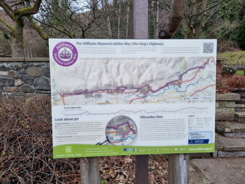
Sign at the bottom of Tillicoultry Glen
The Hillfoots Sections
The Hillfoots villages of Blairlogie, Menstrie, Alva, Tillicoultry and Dollar are sheltered in the lee of the Ochil hills. Each village grew around a fast-flowing burn, necessary for water and power for the meal mills and later woollen and textile mills that once abounded in the area. Each village enjoyed the patronage of a laird on whose ground it was built and who usually resided nearby. The old road from Stirling to Kinross passed through each village a little way up the slope, following the foot of the hills, and sections of the road are still in use. In each village, the oldest cottages can be found at this level, someway uphill of the much straighter and wider 1806 turnpike road, now labelled the A91.
Statute Labour Roads
From 1699 onwards, in Scotland, the Statute Labour Road system obliged people to supply labour, tools, horses and carts for road-mending purposes for up to six days a year without pay. This system was widely resented and very inefficient. The keeper of the records, often the local schoolmaster, had few powers of enforcement, and if he took advantage of them, he was likely to be outlawed by his community. A modification of the system allowed a set sum of money to be paid instead. This helped a little, however there were still problems collecting the money. Despite these difficulties a great number of roads were built at this time, as well as many bridges. However, efforts at road making under the statute labour system proved inadequate for the needs of the agricultural and industrial improvements of the 1700's.
The Hillfoots Turnpike Road
The old Statute Labour Road along the hillfoots was superseded by the new Stirling to Kinross turnpike road (known as The Ochil Turnpike) in 1806. Part of the new turnpike was designed by local landowner Crauford Tait, with curves following the river Devon to provide changing views through the valley.
Turnpike Roads in Scotland
Although there had been some early toll roads, it was not until the mid-1700’s and later that these became firmly established as a means of improving the road system, particularly when advances in agriculture and industry made the need for good roads apparent. Counties could apply for an Act of Parliament allowing them to raise funds to construct roads and recoup the money through the collection of tolls. The system proved very successful and resulted in the country having a good network of roads, although the parish roads funded by the statute labour commutation money were not always in good condition. A separate programme of road building in the Highlands and one or two roads in the Lowlands was carried out from 1802 onwards under the Commission for Highland Roads and Bridges. Competition from the railways from the 1830’s onwards and inherent difficulties with both the turnpike and statute labour system led to a review that eventually led to the disbanding of the turnpike trusts and passing all roads over to the newly formed county councils in the 1880’s.
An excerpt laid out below from the "Report of the Commissioners for enquiring into matters relating to public roads in Scotland", published in 1859, shows just the kind of difficulty that was evident in Clackmannanshire :
VIII. - County of Clackmannan.
The roads in Clackmannanshire extend to about 75 miles - whereof 37 are turnpike, and 38 statute labour roads.
Turnpike Roads.
1. The Clackmannanshire Turnpike - is regulated by an Act passed in 1840, and extends to 20 miles - of which 11 1/2 are in Clackmannanshire, and 8 1/2 in Perthshire. There are seven tolls.
1856-57. Revenue L.1,122 15 0
Maintenance, including surveyor's salary, 746 17 11
1857-58. Revenue L.1,256 1 11
Maintenance, including surveyor's salary, 870 0 1
The road is under the charge of Mr McConnell as surveyor.
The debt, as at Whitsunday, 1858 consisted of :
Bonds containing personal obligation of Trustees, L.14,620 0 0
Postponed debt to Stirling and Dunfermline Railway Company, L 4,400 0 0
Total L.19,020 0 0
Interest at 4 per cent. is usually paid on the preferable debt ; but during the two last years the expenditure, including payment of interest, has exceeded the income.
2. The Kinross and Alloa Turnpike - Constituted under an Act passed in 1829 ( 10th Geo. IV. , cap. 91 ), extends to 17 miles - whereof 6 1/2 are in Clackmannan, 6 in Kinross, and 4 1/2 in Perthshire. There are four tolls on the road.
1856-57. Revenue L.260 5 5
Maintenance L.285 16 5
1857-58 Revenue L.249 16 11
Maintenance L.299 9 8
The road was made by subscriptions from proprietors in the district, and no interest has ever been paid to them. The excess of outlay during the above two years was met from a small accumulation, which is now exhausted. The revenue is still expected to of suffice for keeping up the road , unless it be still further reduced by a projected railway.
3. The Ochil Turnpike - is regulated by an Act passed in 1840. It extends to 26 1/2 miles - whereof 19 are in Clackmannan, 4 1/2 in Perth, 2 in Stirling, and 1 in Fife shires. There are five tolls.
1856-57 Revenue L.1,256 10 11
Expenditure, 814 3 0
1857-1858 Revenue L.1,274 11 11
Expenditure, 857 1 11
The debt consists of Preferable debt, being two-thirds of the borrowed money, taken up by the Trustees liable for it, L.22,826 13 4
Postponed debt, being the remaining one-third, taken up by agreement by the Stirling and Dunfermline Railway Company, and postponed both as to principal and interest, L.11,333 6 8
Total L.34,160 0 0
Any surplus of revenue over expenditure is divided among the preferable creditors as interest. Last year it amounted to about 1 3/4 per cent., being the lowest rate ever paid . It has never exceeded 3 1/2 per cent.
4. The Carnock and Kennet Turnpike - Consisting of 9 miles in all, has half a mile in Clackmannanshire.
Statute Labour Roads
The statute labour roads in Clackmannanshire extend to about 38 miles, and are regulated by the County Statute Labour Act passed in 1802. The assessment is now levied under the Lands Valuation Act, at various rates in the different parishes, as these have been fixed by the Sheriff ; but agricultural land is the only kind of subject embraced in the assessment. There is also a rate of 8s. levied on horses not used in agriculture. The owners of public works occasionally contribute voluntarily to the repair of the roads used for their heavy traffic, but such works are not by law assessable. The total amount of statute labour funds raised in 1857 was L.502, 18s 4d.
The sum collected in each parish is laid out on roads within that parish.
Costs
From the foregoing statement, and the Abstracts in the Appendix, it appears that the average cost of the whole roads in the county of Clackmannan is as follows :
Turnpike roads, L.1,199 6 10
Statute labour roads, 502 18 4
Total L.1,702 5 2
The debt consists of :
Turnpike debt - secured by personal obligation of some of the Trustees, L.8,406 100
Do. on assignation to tolls only, L.27,331 4 0
Total L.35,737 14 0
So it can be seen that many of the turnpike roads were laden with debt which they could not adequately reduce nor in some cases even service the interest on from the tolls. This led to changes to the changes in the 1880's. Initially all roads were managed by trusts and then by county councils. Over the years, considerable improvements were made to the existing roads and new roads built. Many of the main roads today are former turnpikes although now surfaced and with improved alignments. As there could be variations in road standards between counties, the Ministry of Transport took over responsibility for main routes and increasingly set out guidelines and standards to ensure a more uniform road network.
Local government was reorganised in 1929 leading to the formation of highway committees in counties and again in 1974 with the formation of regional councils. As these were larger, a more strategic view could be taken of the road network and many major road schemes date from this period. A further reorganisation took place in 1996 when unitary authorities were formed.
The Hillfoots Statute Labour Road reviewed
In 1798 Thomas Garnett, M.D., a professor in Glasgow University, found the high road in a very good condition. It was, however, too narrow for two vehicles to pass each other without difficulty. At gates (turnpikes) tolls and duties were demanded from vehicles, horsemen and cattle drovers. Nowadays the remaining parts can be travelled free of charge.
Menstrie - The road can be picked up just west of the Auld Brig, erected in 1665. This bridge is a rubble built, humped-back single arch with an inscribed panel on the south face. The stone walls of the 1642 corn mill can still be seen, just north of the Auld Brig. The old road is then continuous from Menstrie Auld Brig to Alva, via Ochil Road, and Long Row, in Menstrie. It is tarred for part of the way and wide enough for farm traffic.
Alva - Just outside Alva at the Balquarn Holiday Cottages, the road is renamed the Back Road. The centre of historic Alva, as with all the Hillfoot communities, is uphill from the main road (Stirling Street) where the old back road (named Back Road, Beauclerc Street, Ochil Road and Burnside Farm Road) crosses the Alva Burn at the entrance to Alva Glen.
Between Alva and Tillicoultry the road splits with a high road and a low road. The high road (at first a single-track tarred road with passing places) goes up by the Woodhill Wood car park (signposted on the A91 on the outskirts of Alva) and then degenerates into a narrow foot path (upper woodhill path), which goes all the way to Tillicoultry. The low road starts off as a narrow path near Alva (lower woodhill path) and goes between fields and then through woods before petering out on the edge of the Tillicoultry Golf Course.
Tillicoultry developed from the small village of Westertown at the upper part of Tillicoultry Burn, by the Middleton and Clock Mills where the old Stirling High Road passed over Middleton Bridge and cut along what is now Frederick Street. The old road line is lost here due to redevelopment of the area, but it can be picked up again outside Tillicoultry at Harviestoun.
At Harviestoun, just east of Tillicoultry, John Tait, a wealthy Edinburgh lawyer, had bought a decent house on the old high road in 1780. His son Crauford, who succeeded him in 1800, was a principal mover in the matter of the new Turnpike Road from Stirling to Kinross. The latter improved both the house and its estate, demolishing the original nearby hamlets on the old road. The stretch of the new Turnpike was designed with curves (known locally as the Dollar bends) following the river Devon to provide changing views through the valley. The old road can be picked up again just west of Harviestoun, the road travels towards Dollar where, just west of the village, it has been re-aligned to join the A91. It can be picked up again in Dollar.
At Dollar, the road is again available via Back Road, over the burn to High Street, and Upper Hillfoot Road. Here the old road is a narrow, tarred road leading to the village of Muckhart. It joins the A91 just on the edge of the Pool of Muckhart.