
This book by W. Scott, published in 1987, gives an account of the Alloa streets from the 1920's, 100 years ago. Many will be able to piece the 1920's layout from this book's description.
Alloa in the 1920's
By W. Scott.
FOREWORD
Mr. Scott spent his working life in Alloa but has retired to the Falkirk area. When he returns to Alloa he is very aware of how it has changed from the busy town he knew. He has realised that it is a diminishing generation which recalls the prosperous community which could claim to be "In the forefront". His own memories are vivid and he decided to write down an imaginary walk around every street as he remembers it in the 1920's.
Already the consequences of the first world war and the developing international depression were beginning to have an impact on Alloa, especially on the ship building, but the railways were bustling with traffic to and from the mills, the breweries, the distilleries and manufactories. Each of these required a range of supporting industries, one of which was Mr. Scott's, a cooperage. There were still steamers, fishing boats and ferries on the Forth. Cinemas, bands, ice-cream parlours, sports teams, rowing, dancing, swimming all filled the much shorter leisure hours of the active population. Horses and bicycles were the main transport on the roads but the petrol-engine was becoming a challenger.
Mr. Scott's memories will take you into streets and a life style which have gone for ever. It is good that he has captured a time at risk of being forgotten.
J. PEACOCK
ASSISTANT DISTRICT LIBRARIAN
JULY, 1987.
ALLOA IN THE 1920's
CHAPTER 1
Today. I have been given the pleasant task of being your guide on a walk around the streets of Alloa in the 1920's. A few readers may well remember some of the places at a different stage from my description of them but, on the whole, this was Alloa 60 years ago. Our tour is an attempt to fill one of the gaps in the story of Alloa in this century and will, I hope, be of some interest to younger and newer inhabitants. At the end of our walk we will notice some or the major changes we find in Alloa.
Clackmannan Road
We must have a starting point for our walk so we will enter the town from Clackmannan Cemetery corner at the (now demolished) east lodge gatehouse into Lord Mar's estate. On our left, the boundary wall runs for one mile along the side of Clackmannan Road till it reaches the North lodge gate beside the bridge crossing the Brathy Burn. The grass field on the other side of the wall is known as Hawkhill. In the centre of the field a standing stone can be seen. There have been many theories put forward as to its origin and what it signifies, but Alloa's history has lost all trace of its purpose.
On our right, the roadway is edged by a footpath and hedge and on the other side of the hedge the Alloa/Dunfermline railway (1850) runs parallel with the road. Clackmannan Road and it's continuation through the centre of the town was built in 1678. On our right the first thing of note is the iron built foot—bridge crossing over the railway, beside it the level-crossing gates and a small white-washed cottage. The people who stay in the cottage are responsible for opening and shutting the gates when required. This gives access to the Hilton Farm and the Whinhall Pit a hundred yards further along the line, and the roadway continues on to the Hilton Fire-clay Works (Buick's) and Carsebridge Distillery. (The pit was closed down in the mid-twenties, and the pit-bing. now overgrown with trees and bushes, is the only reminder of the past existence of the pit) [The pit-bing has recently been uncovered again (2025)].
As we pass the pit, the railway veers to the right, away from the roadway and this creates a small grazing field. (In 1966 the new Alloa Fire station was built in the grazing-field the other part of the field is used as a car-park for the Alloa Football Club) [Now a Lidl Store]. Now we have arrived at the Hilton Road, or "Toll Road" though tolls were abolished in 1880. One hundred yards along this road, the railway crosses the road in the form of a level-crossing with gates which are controlled from a signal box close by. We will make the other side of these gates the finishing point of our walk around the town.
Just past the Hilton Road is the 'Recs' [Recreation Park] the home of Alloa F.C. and next to that another small field, where later, Alexander's Bus depot was built [This building was later converted into industrial units].
Balfour Street
We are now approaching the first street and houses. Balfour Street is a short cul-de-sac street with houses on the west side only. the railway lines cutting off any further extention of the street. We have now moved to the comfort of a granolithic pavement (1895), past three or four nice villa-type houses and we come to Park Place, another cul-de-sac with the railway cutting off the end. This street has stone cottages on one side and a short two storey block and cottages on the opposite side. From Park Place, three or four stone houses and here we are at St. Mungo's Roman Catholic church and school.
The church was first built for the Episcopalian community (1839) and the Catholic community bought it in 1869, when Lord and Lady Mar had St. John's Church built for the Episcopalians in Broad Street.
On the left of Clackmannan Road, the Hawkhill field ends at three terraced cottages. At this part, the roadway starts to slope down towards the Brathy Burn. Opposite the church is the North Lodge gate to the Mar estate. The Brathy Burn flows under the bridge at the foot of Clackmannan Road on its way through the older part of the town to the shore.
At this point in our walk we will divide Alloa into North and South: the South is the old part of the town, the North is the newer part of the town. The dividing line will be the main street which runs through the town from East to West. All the streets are paved with granite cobblestones.
Shillinghill - Auld Brig street - Kirkgate
The first part of the main street is known as Shillinghill. The first doorway on our left opens on to a flight of stone steps leading down to a cottage standing at the edge of the Brathy Burn where it flows out from under the bridge. The next house up on the street level is a two storey dwelling house with an outside stairway on the west gable-end. Next is the Bridge Hotel (Brig Inn), a cottage attached to the hotel, a twenty foot by five wall, then the first shop, Hutchinson's licenced grocery, part of a two-storey dwelling-house. At the end of this building a flight of stone steps leads down to Mill Road.
The next two-storey building, substantial stone built and stretching for about fifty yards, is dwelling houses with the Y.M.C.A. Club at the middle. The end house has a short patch of shrubbery enclosed with an iron railing. A sand patch along the side of the pavement extends about twenty yards, tapering in width from seven feet to nothing where it stops at a gents underground toilet. An iron railing stretches at the back of the sand patch from the shrubbery to the toilet wall, then just past the 'Gent's' a short stretch of railing, 6 feet, ends at a public iron made drinking-fountain. This brings us to the end of Shillinghill.
The Auld Brig (old High Street) starts here and descends at right-angles from Shillinghill. This area is known as Junction Place. Before we walk down the Auld Brig there is another short rough road running back eastwards, parallel with Shillinghill at a lower level. This is Mill Road. It leads to the grain mill of Gray & Harrower, built at the side of the Brathy Burn in 1731. Returning from the Mill, on our left are the beer malt barns of Henderson's Mill Brewery at the top of the 'Auld Brig'. Immediately across the street is the rear entrance to Maclay's Thistle Brewery, within Junction Place.
Going down the 'Auld Brig' on our left is a pend which leads to the rear of Henderson's Brewery and a shed where Bell (the chip-man) stored animal-skins from the local slaughter-house. Then it is rough sandstone dwelling houses for another fifty yards to where the street divides. A Gents iron-built toilet stands there. Keeping to our left, the street slopes downwards towards the Brathy Burn with dwelling houses on each side and, turning to our left at the last house. we walk on to waste ground in what used to be a quarry [Where Tesco is now]. One of Paton Baldwin's new 'flats' is built here with the Brathy Burn flowing through a culvert under the building.
Retracing our steps to the last house, we can continue along the street for 50 or 60 yards past old empty houses. till it comes out at the Trongate and the New Entry in front of Paton & Baldwin's main gate. Local history tells us that it was in an old house in New Entry in 1862 that our own Alloa Co-operative Society was started.
Or, we can retrace our steps to the iron toilet and follow the old High Street as it bends to the right till it too reaches the part known as the Trongate. There was one house/shop here, Bristow's. When the houses on the right-hand side of the street were empty, Maclay's Brewery converted the property into a bottling store and beer cellars right to the end of the street. On the corner of the street is a large three storey building. This is Paton & Baldwin's wool-store. Along the side of this building a narrow 'back-vennel' leads up to the main gate and offices of Maclay's Thistle Brewery. On the opposite side of the vennel are the buildings of George Younger's Brewery, where stands the tallest chimney-stack in Scotland.
Walking straight across the Trongate and the New Entry, with Younger's Brewery on our right and Paton and Baldwin's main gate on our left, we pass by the foot of Candleriggs Street and walk along Greenside Street. On our left is the boundary wall of the new part of Greenside Cemetery, on our right, old houses converted into Paton & Baldwin's joiner and repair shop, and, in the corner, Allan's Rag & Metalyard.
On our left is a two storey house next to the main gate into the cemetery, to our right the large three storey red-brick building of Maclay's malt-barns and behind that the smaller obsolete buildings of Bailey's once famous Pottery Works (1808). From the cemetery gate we continue along Kirkgate. Behind the old wall on the left is the old Parish Churchyard and the ruins of the first St. Mungo's Parish Church. Beside the ruin are the burial vaults of the Erskine Mar ancestors. A short tenement finishes off the left side of Kirkgate where it joins the top of Broad Street, and to complete the right-hand side we have the Star Home Lodging-house, then the ancient house where Tobias Bauchop, known throughout the country as a master stone-mason, lived with next door, a dingy old pub "The Auld Hoose", and Mrs. Graham's second-hand shop on the corner of Coalgate and Broad Street. (The church tower and Bauchop's house are now under the care of the Department of the Environment and the National Trust).
Broad Street - The Shore - Forth Street
We are now at a 'cross road' of streets: to our right Coalgate Street, straight ahead of us Stripehead, a short street leading on to the bottom of Bank Street, and to our left Broad Street, wide enough to take three lanes of traffic, we take this way down to the harbour and the dock and the River Forth.
Walking down Broad Street on our left is a Baker's shop, then one step-up into Goodwillie's house/shop, next door two steps-up into the Eagle Inn public house, a dwelling house, then the iron railings and entrance-gate into St. John's Church. On the opposite side from the corner of Stripehead are The Ship Inn public house, a shop, then a stretch of wall surmounted with iron railings enclosing waste ground, an old Custom-House and a disused Church Manse. Next to that is the large building containing Willison's Copper-Works. This building was originally built as a Free Church in 1790. Still on our right a tenement (St. John's Court), The Lime Tree public-house, another tenement (Paddy's building) and Edna Cottage bring us to the east end of Castle Street.
Look to the left and from St. John's Church a long tenement which also includes a co-operative grocery shop brings us to the boundary wall of the Earl of Mar's estate. At the head of the walk stands a large ornamental stone fountain (1869). About fifty yards along the boundary wall and directly opposite Castle Street we come to the massive iron gates. supported by two tall stone pillars, of the main entrance to the Earl's residence. The boundary wall continues parallel with the boundary wall, in the middle of the street. a double line of lime trees stretches for a hundred fifty yards to the foot of Broad Street. This is known as the Lime Tree Walk and was planted by Dutch sailors in 1714. On the Castle Street side, another boundary wall runs to the foot of Broad Street. Behind it is Walk House, Linden House and the Shore Brewery.
We won't turn left along Bowhouse Road, I'll describe the area for you. Two hundred yards along the road to the Bowhouse Farm the road turns to the right and heads south past the aeroplane works to a group of wooden barrack type homes known locally as 'The Huts'.
Here at the foot of Broad Street, thirty yards in front of us, are a weigh-bridge and a gents' open iron toilet, and about 80 yards beyond that, are the wet dock and the harbour. It is possible to walk across the dock lock-gates and round the dock. At the harbour 4 or 5 fishing-boats are tied-up. Close by is the 'Black-shed' for storing cement. On the quayside it is a weekly event to see barrels of beer being brought across from the Shore Brewery and loaded on to a ship moored at the Quayside, while over at the dock you can watch a cargo boat being loaded with coal from a waggon lifted up from the railway by a giant crane at the dockside. Over near the quayside the ancient Mar Inn is always well patronised. Near-by is the cottage where David Allan the Scottish painter was born in 1744, and not far from it is the 'Auld Ship Inn'.
Turning to our right and crossing over the railway lines we enter Forth Street. On our left, is 'Jeffrey's Shipyard', still referred to as such even though Forth Shipbuilders bought it over in 1918 and McLeod's moved in during the mid twenties. At the far end of the shipyard is the Alloa Ferry pier, where the boat 'Hope' plies to South Alloa across the river. On the right of Forth Street are cottages with small gardens in front. Midway along there is a Custom House and at the end of the houses we find a horse-stable. Beyond the stable is the Ferry Inn and the end of Forth Street. Next to the Ferry Pier is the Alloa Glassworks (1750) and opposite the pier a road leads up a long incline to join Grange Road which is a continuation of the main road through the town that we used as our dividing line. This is Glasshouse Loan.
Craigward - Kelliebank - Caledonian Road
Walking up the left side of the Loan about 150 yards we turn left into Craigward. This street runs due west, on the corner is a long double storey tenement and beyond that The Alloa Gas-Works (1828) ground. On the opposite corner is the large Craigward Cooperage owned by George Younger & Son Brewers, the sheds and yard stretching almost level with the Gas-Works gate. Beyond the Gas-Works is the Kelliebank Shipyard ground with its large three storey red-brick office building forcing the street to run to the right then left and then along the side of the Shipyard boundary fence to the Eglinton Bottle Works. Beyond that is the new Scottish Central Glassworks, then the road goes on through open country with the River Forth a hundred yards away to the left and the Alloa Railway Bridge (1885) crossing the river in the distance.
On the right of Craigward from the end of the Cooperage yard are the Gaswork office, then a two storey dwelling-house followed by a tenement block on the corner. (Actually Kelliebank starts from the gaswork office). From here stretching to the far end of the road and Sellars Foundry which makes agriculture machinery is the boundary fence of the marshalling yard of the Caledonian Goods Station. Beyond the foundry is the small factory of George Younger's box and crates, a cottage, then open farmland. Opposite the central glasshouse there is a pedestrian tunnel under the railways of the marshalling yard which comes out on the Caledonian Road near the main gate of the Harland's Engineering Works.
Instead of going through the tunnel we will go back along Craig ward to the cooperage corner and turn left up Glasshouse Loan for 50 yards to the gates of the Caledonian Goods Station and left again into Caledonian Road. All the way along on our left is the northern boundary fence of the Marshalling yard. Here on our right is the large five storey Craigward Maltings built in 1868 for George Younger Son, Brewers. Next to the Maltings are the buildings and cart-horse stables of the Bass Crest Brewery, also owned by George Youngers. From here where we are standing looking along the Caledonian Road towards the Harlands Engineering Company, Wightman's Box Factory and the Harland's workers' canteen are the only buildings on the open waste-land. Away over on the far right is Forbes Street with the tenement houses along one side only, facing the open waste-land. In 1925 George Younger's firm presented their employees with a Recreation Hut, to be known as the Bellevue Hut, within the Bass Crest ground at the corner of Grant Street. Grant Street leads us up onto Grange Road. Near the top, on the left-hand corner is the St. John's School (1902). All the way on our right is the boundary fence of the Bass-Crest Brewery.
Grange Road - Castle Street - The Waggonway
Turning left into Grange Road and walking fifty yards we arrive at the top of Smithfield Loan. On either corner is a wall enclosing trees and a large villa. About fifty yards down Smithfield Loan on our left is a short one-sided street, Medwyn Place leading to Forbes Street. From the corner of Medwyn Place a long red-brick two storey tenement stretches for sixty yards, and completing that side, four terraced cottages and a short road to the left through to Harlands Engineering works. Here we turn back towards Grange Road and on our left is the housing scheme Dirleton Gardens. with Mitchell Crescent as its main street. This scheme is Alloa's first Council Housing Scheme (1921). It is bounded on the north-west by the embankment of the Alloa - Larbert railway heading for the Alloa Bridge over the River Forth. The original Dirleton Gardens is the terrace of semi-detached cottages you see stretching away to our left. There is a Co-operative Grocery shop at the end of the terrace.
Back on the Grange Road we pass the Grange School on our left and fifty yards further along is the Grange level-crossing and the west end signal-box. On the other side of the gates the road continues as Stirling Road, with the foot of Alexandra Drive immediately to the right of the gates. Continuing west along the road on our right are the entrance lodge-gates into Cowden Park and the Norwood Estates, and the Pleasure Grounds (1923) beyond. Opposite the Pleasure Grounds is 'The Arns', the ground of the Clackmannan County Cricket Club.
On a Sunday hundreds of people parade from the level-crossing to the far end of the Pleasure Grounds and back again, just for the fun-of-it!
Returning along the Grange Road towards the town, on our left are signalmen's cottages and a gateway into the West End Public Park (1878). Between this gate and the large main entrance gates into the park is a mixture of stone cottages and villas. Beyond the main gate a row of nice villas enhances Alloa's approach road from the west, a sign of prosperity in an earlier era.
Opposite the main gate the boundary wall of the Bass Crest ends and the Grange Road garden nursery takes up the rest of the ground along to the top of Glasshouse Loan. The Alloa tennis club have their tennis courts in a part of the nursery ground.
We will walk down Glasshouse Loan, with, over the wall, the marshalling yard of the L.N.E.R. Goods Station on our left. Passing Craig ward on our right we turn left into a long wide street, Castle Street. On our right are two storey houses for three-quarters of its length, Park Lane Mission is just behind them. Then a short one-sided street to the right takes you down to Forth Street. This is Carron Street, with the railway and waggon road running on its left hand side. On our left the boundary fence of the L.N.E.R. Goods Station continues for fifty-yards. then an opening through to a small engineering work, two old cottages and the premises of Scott the potato merchant on the corner of Ward Street.
Ward Street is a short cul-de-sac off Castle Street. A Co-op grocer shop and a four house block are all that is in this street. but, from it another short cul-de-sac, North Castle Street, runs east and parallel with Castle Street. This has houses on both sides with the end blocked off by an iron footbridge over the railway lines that run from the goods station to the dock and the shipyard.
From the corner of Ward Street the houses along Castle Street are set back from the street and have small gardens in front, similar to the houses in Forth Street. At the end of the row of houses and beside the railway lines and the waggon road rails cutting across Castle Street, the large enclosed building is the local 'Model Lodging House'. It was originally built as a school. From here the rest of Castle Street is plain.
Crossing the 'line', on our right a private boundary wall runs for a hundred yards to where the street meets Broad Street, and, on our left, a corrugated boundary fence enclosing MacDonalds Cooperage and yard, ends at a house/shop on the corner of Broad Street.
To continue our journey we will walk from the Model Lodging House up the Waggonroad. Behind the low wall along the right side of the Waggonroad are the gardens of the houses in Broad Street, and, on our left, the iron foot-bridge over the railway, followed by the beer warehouses of George Younger & Son, brewers. On our right, we have arrived at the rear of Willison's Brass and Copper Works, and along the side of the works is Cunninghar Close, a passage-way to Broad Street. In front of us is the first tunnel on the waggon-road. We will go up this path at the side of the General Post Office (1925). It will take us on to the foot of Bank Street.
Bedford Place - Bank Street - Coalgate
Before we walk up the town, I will describe the area here for you, looking along Bedford Place to the bridge at the top of Glasshouse Loan. The first building on our left is the South Primary School, and next come two dwelling houses which are actually slightly below the level of the street. Originally one of these was a bank. Beyond them is St. Mungo's Parish Church Hall, and the magnificent structure of the Alloa St. Mungo's Church built in 1819.
It embodies the pride of the people of Alloa no matter what congregation they belong to. What a pity it was not built upon the highest ground in Alloa where it's grandeur could have been seen for miles around. A dampening effect on our enthusiasm is the amazing fact that the main entrance to the L.N.E.R. Goods Station is between the hall and the church!. On the other side of the church is a villa enclosed by a high wall, and to complete the picture, two villa-type houses slightly below the street level, Alloa's first lady doctor, Dr. Mary Stevenson, stayed in one of these.
Now to continue with our walk. We are now standing with the General post Office behind us. To our right is Stripehead, a short street crossing the top of Broad Street to join Kirkgate. Straight ahead is Bank Street with a small white-washed cottage with red pan-tile roof, and a two storey old house on the corner on our right. (This corner was later demolished and the new gas showroom and workshop built on the site). Next is the garage for George Younger and Son (Brewers) motor-lorries on the corner of Union Street, a very short street through to Coalgate. George Younger's head office occupies the left side of Union Street.
Past Union Street are the Unionist Club Rooms, Erskine's Toy Shop and Cooper's Grocer Shop at the corner of Meadow Square. This is a small paved square with four house-flats at the rear, the two top flats being entered by an outside stair, and on its other corner the Clydesdale Bank.
For a period just after the 1914/19 war a field-gun was placed in the Square as a war souvenir. Next to the Clydesdale Bank is William Dow's Butcher Shop, then a jeweller's on the corner of Coalgate Street with a large Greenwich time-clock above the shop door. Coalgate leads to the top of Broad Street and on our right is the doorway to a house above the jeweller's, then a wooden gate giving access to the rear of the Dow's butcher shop and the Clydesdale Bank. Next is Laurie Thomson's chip-shop and a covered passageway through to Meadow Square, then H. Hughes barber-shop, the gable-end of Younger's office and the corner of Union Street. From the other corner of Union Street to the corner of Stripehead is a building which contained a dwelling-house, fruit shop, Thomson's barber shop. These shops were always changing their occupations.
Going back up Coalgate, on our right and on the corner with Kirkgate, is Mrs. Graham's clothes shop, then the Red Lion Public-house, Peter Keir's saw-shop, the doorway and two large windows of Scott's antique and second-hand shop, two small shops, a 'close' entrance to houses above the shops, then Charlie Edward's fruit shop at the corner of the West Vennel. On the opposite corner of West Vennel, the Baronial Buildings (Pawn shop), originally built n 1878 as the Anchor Tavern, has three shops at street level. Next to that is Fleming's grain-food shop and Harrower's newsagent's shop on the corner with Mill Street.
Candleriggs - Mill Street
Continuing along Mill Street on our right are Dawson and Lennox licenced grocer's shop. Lindsay and Low's grocery shop, a covered passage through to the yards behind the shops, co-operative butcher-shop, Duncan's grocers then Buchanan's shoe shop at the top corner of Candleriggs. Looking down to our right we can see the main gate into Paton and Baldwin's Mill, and, as we walk down Candleriggs, on our right are a door into an office above the shoe shop, a barber shop, a cobbler's shop, Taylor's baker shop and bakehouse, a drysalter/wallpaper shop and the corner with West Vennel.
This is a dingy back-street with old houses along the right-hand side that joins up with Coalgate at the Baronial Buildings corner. On Its left dwelling houses have been converted into Younger's beer-cellars, for three quarters of it's length. Then there's a passageway through to the Kirkgate and Greenside, Hell Close. To complete the Vennel are McPherson's old dingy pub and Charlie Edward's fruit-shop. Edward also had a small stable at the side of the passage-way. The cobble-stones in the Vennel are severely rutted by the iron-ringed wheels of the heavy loaded beer-lorries and make rough walking.
Back to Candleriggs, and after West Vennel we come to the entrance gate to the beer cellars, two tenement houses and we arrive at the bottom of Candleriggs. Facing us is Paton's main-gate. and a short road between Paton's office building and Greenside Mission Hall, leading to a lodge-gate into the Earl of Mar's estate and the Alloa Tower. Turning our steps back up Candleriggs we have George Younger & Son's large brewery on our right and its main gate. The building covers the ground along to the corner of the East Vennel, and its beer cellars then continue along the Vennel till it reaches the back Vennel from the Old High Street we saw at the start of our walk. Maclay's Thistle Brewery Head Office and main-gate close off the end of the East Vennel and we turn back towards Candleriggs. A small occupied cottage, then several old disused buildings, one of which had been a Church of some kind, bring us to the Alloa Journal Printing Office on the corner and back into Candleriggs. Next to the Journal Office is Mitchell's joiner shop, office and yard, George Cram's pub, then Barron the jeweller's shop, a doorway leading upstairs to the Toc H hall over the shops, and, on the corner with Mill Street, Lipton's grocer shop.
Before we move on I should tell you that here, at the junction of Candleriggs, Mar Street and Mill Street is the 'Alloa Cross': 4 flat stones roughly in size 24" x 12" each, inlaid in the middle of the street in the form of a cross. During the six working days of the week you would always find a policeman on duty at the 'Cross'. It was to this 'hallowed spot' that the people of Alloa (75% teenagers) assembled on the night of 'Hogmanay' to celebrate the dawning of a New Year. As the hour of midnight approached, a kilted piper would start playing a 'Scottish Reel' on his bagpipes. That was the signal for a foursome reel to make space in the centre of the crowd at "The Cross" and hooch and yell' with delight as they danced. On the outskirts of the crowd other groups were 'birling and skipping' to the music of the piper. The crowd would be hushed, the music silent, as everyone waited for the ring of the 'bells' from St. John's Church announcing the dawn of a New Year. with everyone singing a 'Guid New Year', shaking hands, kissing. then groups of young people setting off to 'First Foot' their families and friends. No fighting, no broken windows. no vandalism, and no foul language, everybody happy and the policeman joining in the fun!
To carry on with our walk along Mill Street from Lipton's shop next come Ormiston's chemist shop, Moir's boot shop, A. Cairns ironmongers, Marshall's bootshop, the passage entrance to the Temperance Hotel, Forte's café, and the La Scala picture house. Past the picture house is a large 3 storey tenement with shops on the street level, including the Maypole shop, Colleti's cafe, then along to John Lee's red tiled cottage/fruit, vegetable shop, a gents outfitters, Fraser Carmichael's licensed grocery, a doorway to a house above the shop and, on the corner to Old Bridge Street is the Junction Bar public house (Thistle Bar), a close entrance to houses above John Doyle's boot-repair shop, Andrew Sharp's barber shop, and the rear entrance to Maclay's Brewery.
(several shops changed hands in the twenties: Hutton's fish-shop, Munro's butcher-shop, the woolshop, Binnie's cycle-shop, Grant's furniture shop. There was always change of some sort).
This ends our tour of the older part of town. Now we will walk along Shillinghill to the foot of Clackmannan Road and start from there on our tour of the north and newer part of the town.
CHAPTER 2
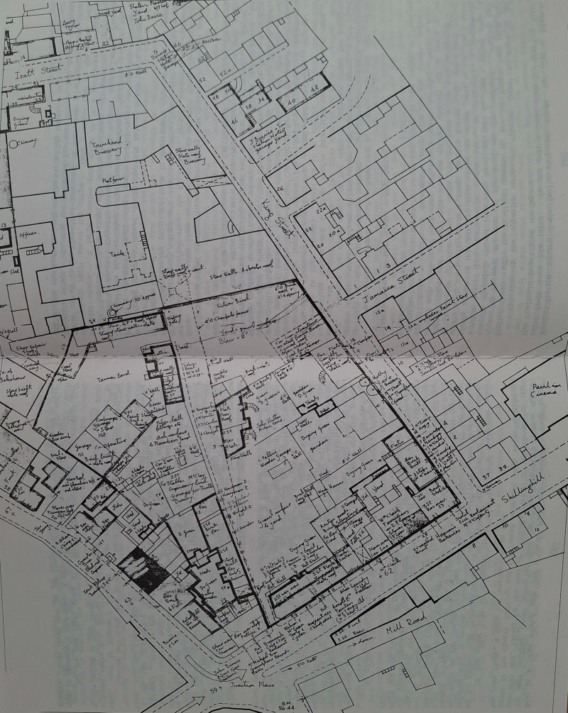
Shillinghill - King Street - Back o' Dykes
Leaving the foot of Clackmannan Road, the road branching away to our right is Gaberston Road. We will return to this to complete our walk. on our right is the drive-way up to a doctor's villa. (Later this area was demolished and a billiard hall built for 'Bobby' Orrock, one of Alloa football club players. The next proprietor was Mr. Hutchinson). The picturesque looking building next to it is the Pavilion Theatre, then Hay's clothes-shop and house, and we are at the corner of King Street.
Walking up King Street, on our right a large wooden gate leads into Jeffrey Binnie's joiner-workshop, a short tenement block of houses and we are at the corner of Jamaica Street. This is a cul-de-sac with McCall's coach-builders yard, and Hibbert's bottling store on the right. The bottom of the street is blocked off by the railway-line fence. and on the opposite side Dickie's wood turning-workshop, woodyard, and a two-storey block of three houses completes Jamaica Street.
Back in King Street on our right are two cottages then the opening down to Colin Bell's (chip-man) yard and horse-stables. From Bell's yard are two storey houses to the corner with Izat Street where Davie's plasterer bricklayer yard adjoins Starkey's scrap-metal yard.
On the left corner of Shillinghill/King Street is a large three storey building with an entry in King Street to the dwelling houses above the street level shops on the Shillinghill side. Next on the left is a substantial house, perhaps intended as a Manse for the large church or meeting-house (Melville Church) which stands to its rear, and a block of four houses bring us opposite Jamaica Street. A 30 yard stretch of wall guarding an orchard is followed by a two storey tenement stretching about 50 yards to the corner where the street turns left and becomes Izat Street. In Izat Street for about 40 yards it is two storey houses on both sides, then it turns sharply first right, then left, and opens on to the Station Square. The Waggon Road from Sauchie appears here, running from behind Davie' s yard and Starkey's yard to cut across the Station Square and pass between the Coalfauld yard and the rear of the Station Hotel on the corner of Primrose Street. Facing on to the Station Square and Wagonway in Izat Street are a sweet shop, Sub Post Office and Smith's glazier shop at the corner with Primrose Street.
Back now to Shillinghill and the large corner building at the foot of King Street. First is J. Binnie's cycle-shop, then J. Hutton's grocery and Wm. Clark's three storey carpet and furniture shop. The buildings now drop to two storey: Miss Fargie's 'sweetie-shop' where patrons buy their 'sweets' before going into the Pavilion Theatre, Swales cobbler-shop, an entrance to houses above a pend through to a yard behind Clark's shop, another small confectioner's, Arnott's wallpaper-shop. then Mrs. Wright's 'wee general shop' where anyone could go in and enjoy a cup of tea and a Co-op mince pie. Next door is Marjoribanks tailor shop at the corner of Back o' Dykes, another cul-de-sac .
Back o' Dykes is a rough cobbled street, with a slight incline. Starting on the right side a wide pend opens into a courtyard, Mill Court, over-shadowed by the 3 storey tenement building that contains Arnott's, Wright's and Marjoribanks shops on Shillinghlll. Here, outside stone stairs lead to the upper flats of the two storey houses on Back o' Dykes. Thig tenement contains five houses and on the street it is followed by a stone wall enclosing the ground of the East Church which we saw behind the Manse in King Street. Next is a two storey tenement, (4 houses at street level with three houses above entered by stone stairs at the rear of the building) and attached to the gable-end of the building is the horse-stable belonging to Blair's Brewery. Can you imagine trying to sleep in the bedroom through the wall? From the stable a high wooden fence stretched for about 20 yards to that part of the brewery building which blocks off the top of the street. Behind the wooden fence is the orchard, already seen from King Street. Turning back down the street on our right is a self-contained house owned by the brewery, a 2 Storey block of 4 houses, 3 terraced cottages with red pan-tile roofs, and adjoining the end cottage a 2 storey red-brick square building. This is Maclay's Thistle Brewery horse and cart stables. From the end of the stables a 2 storey tenement runs almost to the bottom of the street where another pend opens through to the rear of these houses. Completing Back o' Dykes is D. Pelleci's chip-shop/cafe with it's entrance on the Shillinghill. Next to the cafe, McMichael s music-shop and Murray's licensed grocer-shop take us to the corner of Drysdale Street. This short area had Brunswick Place painted above the doorway of the grocer-shop.
Drysdale Street - Primrose Street
We are walking into new territory now that opens into every part north of our agreed dividing line, the main road through the town. On the opposite corner is the Commercial Hotel and going up Drysdale Street, on our right-hand side for about 50 yards is a red-sandstone 2 storey tenement building with the Parish Register Office at the end, and a white-washed cottage. (This was demolished later and two small shops were built on the site). Robert Allan's house and china-shop are next in line before we come to James Young's plumbers shop with the workshop at the rear. This building is very old property with a derelict wooden outside stair at the rear. Here we come to a high red-sandstone building built in 1895, a Co-op building with dwelling flats above the shop at street level, fruit and vegetables, butcher's shop and a fish shop which also sells milk. The next buildings are 2 storey, the Star Inn Public House, Young the plumber's hardware shop, McKee's toy-shop and D. Hunter's saddler's shop on the corner of Primrose Street.
Turning right into Primrose Street leads to the Station Square and Alloa's railway passenger station. This large 3 storey building on our right is the Alloa Co-operative Offices and Emporium, the baker shop with it's own bake-house at the rear, clothes shop. furniture and carpet department, boot and shoe department at the corner of Primrose Place. (a short cul-de-sac ending at the entrance and the main gate of Blair's Townhead Brewery). On its right the Co-op building stretches to the brewery gate. The other side is taken up with Alloa's Public Swimming Baths incorporating a gymnasium and a billiard hall. The wide main entrance of this large building is on Primrose Street. After the baths is Westwater's gents shop, Nimmo's children's clothes shop, a passage-way to the flats above the shops. Bertolini's cafe, Primrose Bar public-house, and Smith's glazier shop on the corner with Izat Street that faces the Station Square.
Within station square colin Bell's chip-cart stands, and Charlie Edwards sells fruit from his lorry. On our left a long, high bill-hoarding hides the coalfauld Depot from the Square.
Crossing to the opposite corner of Primrose Street we stand by the station Hotel (with the Coalfauld behind it, and the Waggon Road rails disappearing between the rear of the Hotel and the Coalfauld).Walking back towards Drysdale Street from the Hotel we pass G. Boag's barber shop, a wooden gate, then Alexander's grocer shop, an optician's, a passage-way giving access to the dwelling-flats above the shops, next is J.B. Rae's newsagents shop. a photographer's shop, Smith's barber shop, and a pend through to Chalmer's plumber-shop. Here now we have a low wall surmounted with iron railings and behind them a stone cottage slightly out of place on one of the main streets. Next come a butcher, ladies hat-shop, Mailer's music-shop, Johnman's painter decorator's shop, the Railway Tavern, McQueen's newspaper shop, and McLeod's newspaper shop at the corner of Primrose Street and Drysdale Street.
Drysdale Street - Mill Street - High Street
We cross over to J. Robertson's cycle shop on the corner of High Street and Drysdale Street. There is a gent's underground toilet in the street in front on the shop, and on the pavement, a red pillar box. Passing the cycle shop, on the right of Drysdale Street the buildings are old and in poor condition. The first doorway is Allan's rag-shop, then two dwelling houses and a large wooden gate (the rear entrance to some of the shops in High Street). Next to it is another large gate, the entrance to Maclay's Brewery dry-grain store, a red brick building. Attached to it is a 2 storey four-house block and a small gents shop. A wooden-gate entrance leads to the cellar of the Commercial Hotel on the corner of Drysdale Street and Mill Street. We turn right along Mill Street (the main street and our dividing line. Next to the Commercial Hotel is Willie Black's haberdasher's shop. White's store, the Danish grocer, Fusco's cafe, a covered passage leading to the houses above the shops. Forbes and McEwan's, its two large windows displaying ladies and children's clothes only, J. Dunbar's Jeweller's shop, Miss Flockart's baby-linen shop, James Lee's fruit shop. Hepworth's and Cargil newsagents and the National Bank forming the corner with High Street.
On the right of High Street next to the bank building is Sharp's grocer-shop, then a double shop (a jeweller and an umbrella shop) the Co-operative tobacconist and barber-shop, the Royal Bank, Brown's bakershop and restaurant. Orchard fruit shop, Simpson's electrical shop, Toma's fish and chip shop. Keith's confectionery shop and back to Robertson's cycle shop on the corner of Drysdale Street.
Going up High Street on the opposite side is MacFarlane's newsagent's, Palfrey's chemist, small shop gent's outfitters, a baker shop, Davidson, ironmonger, a saddler shop, Davidson's hatshop, Sinclair's butcher shop, Campbell's double draper's shops, Black's butcher shop, Central Picture House. Becher's pork shop. C. Dali's fruit shop, Co-operative grocer and chemist shops. A large wooden gate opens on to a passageway leading to the 'Co-op Hall' above the shops. Then a slight rise in the street here takes us up to the Townhead Tearooms at the corner where High Street joins Drysdale Street. Turning the Townhead Tearooms corner, next to the tearooms and within the same building are the Girls Club rooms.
Next is a large wooden gate into a yard. Faunt the Jeweller's shop is in the next building (later converted into the Clackmannanshire Police Headquarters) and, taking up the rest of Drysdale Street to the corner of Mar Street is the County Building and Court house with its high tower containing the Town Clock, four faces and weathervane on top.
On the other side of Drysdale street from McLeod's newspaper shop on the corner with Primrose Street, a small fruit then an old 2 storey building with a wooden outside stair at the rear. (This place was referred to locally as the Teapot Close and has since been demolished and the County Council Architects Office and a ladies public toilet built on the site.) Next, a villa (Moncrieff House), then the open frontage of the Moncrieff Church (1850) which stands back from the street, bring us to the end of Drysdale Street and opposite the County Buildings. As a matter of small interest the County Buildings were built in the same year (1860) as the Wallace Monument at Causewayhead. At that time it was in Clackmannanshire and half the cost of the monument was paid by the people of Clackmannanshire.
We cross Drysdsale Street to the main entrance of the County Buildings in Mar Street. Stone sculptured figures are placed high up on the building and stone steps lead up to the doorway. In the basement are the prison cells. The next building is entered through an arched pend with a stone sculptured horse's head above the entrance. It leads to a blacksmith's smiddy. The building also incorporates the local Telephone Exchange. After the blacksmith's smiddy is an empty space on which the Salvation Army have built a wooden hall to hold their meetings. The next house is Kerr the architect's house. slightly larger than the next row of 2 storey houses. The Oddfellows Friendly Society occupy the first ground floor house and 4 doors further down is White's plumber business, then Maule's bakery and shop (later Hope's bakery), a wide wooden door into Davidson the ironmonger's store-room, then the large display windows of J. Stirling Sons on the corner of Mar Street and Mill Street.
Across the street from the County Buildings are lawyers offices and a flat above. From there a low stone wall topped with iron railings stretches almost to the bottom of the street. Behind the railings, trees and shrubs obscure 4 large villas built back from the street. (The first villa Mar House, became the site of St. Mungo's R.C. Church in 1961; the second villa became the Bank of Scotland; the third, Torridon House, a nice Georgian fronted building (with a large extension added to the rear of the building in 1938) became the headquarters of the Alloa Y.M.C.A., until 1982 when the District Council acquired it; the fourth villa was demolished and the co-operative Society built new offices on the site, and it is now the District Library). Next is the imposing building of the Liberal Club, erected 1904, It has two distinctive bay-windows. Hamilton, tobacconist, Singer sewing shop, with the Linen Bank on the corner complete this side.
Looking left along Mill Street we have the main glass door into Stirling's shop, next is Stanton's licensed grocer shop, a passage giving access to a house above R.S. McColl's confectionery shop and MacFarlane's paper shop at the bottom of High Street. But we turn right along Mill Street past the Linen Bank. The next shop is Greenlee's shoe-shop, a small house-hold shop, Wingate & Low, grocers, (later taken over by the Co-operative as their hardware store in 1932. They had a crazy golf course in the store at the rear - 2d per round).
Next is Cumming's chemist shop thon Morrison's gents shop. Miss Begg's wool shop, McDonald's newspaper shop, the Buttercup shop and a photographers.
Here Mill Stroot ends and we are back in Bank Street. On the North side, Chalmer's United Free Church, built in 1856 is a fine gothic style building. Between the church and the Crown Hotel a wide entrance leads to the rear of the hotel and the Burgh Yard. The local fire brigade have their premises at the rear or the church. Next to the hotel we find the adjoining buildings stand further back from the pavement to form a sort of paved forecourt. In the corner is Arthur West's sports shop, next an office, then the former Alloa General Post Office in the other corner. These buildings have the date 1882 embossed on the front. The next building brings the structure forward again. This is the more imposing Municipal Building with stone steps leading up to the main entrance with two round stone pillars supporting a canopy above the doorway and fronted by iron railings. Behind the railings stands the 'Old Mercat Cross'. (In January of 1939. two men were chained to these railings as a protest against unemployment and hardship). At the side, an arched pend leads through to the Police Office and the rear of the Burgh Building, while out on the street level is the burgh weighbridge.
The next building stands by itself and contains the Commercial Bank and lawyers offices. From here are shops (the Alloa Dairy Company. an insurance office, a confectionery shop, McEwan painter and decorator) with flats above. On the corner at that time, stood a two storey stone house. This house was removed stone by stone and rebuilt near the top of Alexander Drive. When the house was removed it revealed a small red-tiled warehouse. The site was cleared and the whole corner made into Alloa's War Memorial, a splendid statue of a group of three soldiers with an angel standing guard over them. In the background is a wall covered with bronze plaques inscribed with the names of the local people who were killed in the war of 1914/18. The ground is nicely set-out with flower beds.
Church Street - Glebe Terrace - Ludgate
We walk round the memorial and, going up Church Street, the first building on our right is Alloa's first Museum Hall, built 1873. (This has been in turn Masonic Hall, Unemployment Office, Alloa Public Library, and Weir Pumps Social Club). Between the memorial ground and the museum hall the waggonway goes beneath Bedford Place and appears alongside the new General Post Office - the point at which we left the waggonway on our tour of the old town. Continuing up Church Street to where it joins Marshill Road are single and semi-detached stone cottages. Turning back at the top of Church Street, a stone wall and iron railings enclosing a grass field known as the Glebe takes us to Glebe Terrace (a street with stone villas on both sides leading to Ludgate). From Glebe Terrace, there are stone villas and White's garage on the corner of Bedford Place.
Round the corner is the Royal Oak Hotel, then the ground of the West Church built in 1864 on the corner of Ludgate Road (I should mention here that Ludgate is a long road that crosses Claremont and finishes at Tullibody Road, which we will come to later). Between the West Church and the bridge at the top of Glasshouse Loan where the railway line runs under the bridge on it's way to the L.N.E.R. Goods Station are two villas behind a screen of trees.
Here at Glasshouse Loan, on the west side an iron track-way is laid into the roadway to try and make easier for the horses to pull their lorry heavily loaded with bags or grain destined for the distillery and the breweries. It often requires the help of a 'tracer-horse' to pull the load up the steep gradient of the Loan.
Behind the West Church is a slip road leading from Ludgate to the stables of the Royal Oak Hotel. Two villa type houses bring us to the corner of Glebe Terrace. Continuing up Ludgate on our right are four semi-detached stone cottages and the boundary wall of Colville's Garden Nursery (1874) on the corner with Marshill. The wall continues round Colville's Nursery along Marshill past the east part of the Glebe field to the top of Church Street. Local butchers use the field for their cattle and sheep and it is nothing unusual to see the animals being herded through the street up to the slaughter house (Abattoir) in Greenfield Street in the top part of the town.
Back to the foot of Ludgate, and about 50 or 60 yards up on the left we come to Coningsby Place. This is a short cul-de-sac with four or five stone cottages on its left, a large villa and the Alloa West End Bowling Club (1845) on the right. At the far end of the street the L.N.E.R. railway runs below the street level with access to the West End Public Park on the other side of the line by an iron foot-bridge. Above Coningsby Place are three or four terraced cottages. Next come the domestic science and woodwork classrooms and the playground of the Alloa Academy (1824).
Claremont - Marshill
We are now bearing left to walk up Claremont past the main building of the Academy and the north entrance gate into the West End Public Park (1878). The park has a nice covered bandstand and several iron seats fixed in a convenient position around the bandstand allowing the music lovers to rest and enjoy the music of the local burgh brass band. Immediately past the park entrance we cross the bridge over the Alloa-Stirling-Glasgow railway which runs along the north side of the park and over the Grange Road level-crossing, before it divides into one line heading for Cambus and Stirling and the other branching away to the left to Alloa's own Forth Railway Bridge (1882). On our left, a row of good stone houses and four large houses standing within their own private tree-lined grounds brings us to Alexandra Drive. This has a large mansion house on the corner, the rebuilt house from Bank Street, two bungalows, a small field, then the railwaymen's cottages next to the crossing on the Grange Road. On the other side are a grass field and the gardens of Claremont villas.
Leaving Alexandra Drive on our left, the corner house is the manse of the Moncrieff Church, followed by three large villas including the manse of St. Mungo's Parish Church, then the lodge-house of Cowden Park, a wooded estate. (Its main entrance gate is down at the corner of Alexandra Drive on the Stirling road) . The next wooded estate is Norwood. Its boundary wall carries on for another 100 yards, turns sharply to the left, runs downhill past a corn field and the end of the Pleasure Grounds (1923) to the Stirling road and the main entrance gate.
Claremont road ends where the Norwood wall turns down past the corn field, but the road continues as the 'Old Road' a mere country cart road between hedges, fields and bramble bushes and a 'ditch' on one side. It runs through a wood plantation. past the grounds of Dunmar House on to Lornshill Farm road then down to Tullibody Road. Turn right past The Gean House on the road into the town and this makes a popular walk for young and old.
(The corn field next to the Norwood wall became the site of the new Alloa Academy in 1959. The field on the other side of Claremont beside the Gean Lodge house. partly cultivated with turnips, potatoes and hay had the Alloa rugby pitch at the lower part of the field. On the Tullibody Road, in 1925 Paton and Baldwin's built a sports complex for their employees on the eastern part of the field. The Council had the Fairyburn Housing Estate built on the rest in 1952. Then the private developers moved in and built a new road and new bungalows extending Claremont right up the 'Old Road' - a great improvement no doubt about that!)
Coming back down the north side of Claremont there are six semi-detached stone houses before the corner with Victoria Street (opposite Alexandra Drive). Victoria Street is a short cul-de-sac with only six or seven attached stone houses on the right and, a small field on the left. Later it was opened through to Tullibody Road with private bungalows built on each side.
After Victoria Street, two villas and we arrive at the top of Paton Street, a street of stone cottages on either side leading to Tullibody Road. Past two more villas well back from the street and a cottage and we reach Fenton Street. This half street of stone cottages turns in a U-bend to the right to make another short street back to Claremont. It is named North Street and has houses on one side only. (Fenton Street was later opened on to Tullibody Road with a motor garage built on a site on the edge of Tullibody Road). After North Street we pass two houses and come to the junction of Ochil Street and Kellie Place. Ochil Street forks left, with cottages and two storey buildings through to Tullibody Road. Kellie Place forks right, has dwellings similar to Ochil Street and also joins Tullibody Road.
We are now back at the bridge over the railway with the Academy on our right. On our left a small triangular grass field is created by Ludgate crossing a bridge over the railway emerging from Alloa Station and cutting through Kellie Place on it's way to Tullibody Road. The field has large trees growing along the Claremont side and the Ludgate side and cattle graze in this small park. (It became a putting-green for a season before being landscaped with paths, seats and shrubs. The Boer War Memorial which stood in the centre of the street in front of the County Buildings was moved to this site giving it a more dignified appearance). As Ludgate crosses Kellie Place the short distance to Tullibody Road becomes Ludgate Place. The Baptist church is on the left and St. Andrew's large church on the right-hand corner at Tullibody Road. (Both churches were built in 1881).
Mar Place - Tullibody Road
From the Claremont/ Ludgate junction opposite Colville's corner we walk along Marshill. On our left we pass a large villa and two more villas before the Alloa Town Hall (1887) which is directly opposite the top of Church Street. Two stone cottages brings us to the end of Marshill. On the Church Street side, are the boundary wall and buildings of the local Territorial Drill Hall at the corner of Mar Street. Above the doorway is a faded sculptured farm plough and at the side the date (1882), the sign in days gone by of the Plough Hotel.
You will have noticed at thig stage that most of the streets we passed on the left of Claremont joined Tulllbody Road. So we will walk out to Tullibody Road and discover what lies in that region. Straight ahead from the steps of the Drill Hall is Mar Place. On our right is a large villa (Mar Place House) and to the right behind the villa, a wide roadway leads to the Coalfauld Depot on the edge of the Station Square. (You can bring your own barrow and get a bag of coal for a 1/-). Corning back up the roadway from the Coalfauld on the other side, the Co-operative horse stables, the Co-op Funeral Hearse Department, the joiner shop, the blacksmith's - smiddy, then the cart-sheds and yard brings us back on to Mar Place. On our right the wall of the yard then a row terraced houses with back gardens. (These were later demolished and the Alloa Bus Station built on the site). Next comes a small warehouse, (the Mar Cafe is on this site now). From the warehouse another three or four terraced houses and we are at Mar Place railway bridge looking down on to the platforms of Alloa's Passenger Station. A short-cut along to the Station here is known as the Station Lane. From the bridge we pass a large wooden poster-hoarding then a slip-road down to a railway siding and Millar's private garage. A three storey block of houses, then a long stretch of stone built terrace houses with attics brings us to the boundary wall of Greenfield House grounds. From opposite St. Andrews Church the boundary wall with the main entrance gate / lodge into Greenfield House grounds stretched for 100 yards along the edge of the pavement then turned to the right up Hill Street.
Along the left side of Mar Place from the Marshill corner are Mrs. Watson's confectionery shop, another small fruit shop, three house doors and the railings at the rear of the Town Hall ground. Next to the railway bridge is the Y.M.C.A. hut and across the bridge Lance's electrical shop and house. We pass the end of Kellie Place, then a wooden garden fence brings us to St. Andrew's Church at the end of Ludgate Place. From the Church, Short's small general shop and house, then a raised piece of ground fronted with iron railings with three terraced cottages back from the street bring us to the bottom of Ochil Street.
Having already partly described Tullibody Road I will complete my survey of the left hand side from Ochil Street. A two storey block of six houses, the top storey being entered by an outside stair at the rear is known as Tudno Building. Next is Millar's farm house and the stackyard. (The stackyard became the site for Alloa Motor Company Garage). A short grass area and one walled-in cottage take us to the bottom of Paton Street and beyond Paton Street is a short stretch of terraced houses. From there it is a field and an open view along to the wooded grounds of the Gean House. (Later Victoria Street was opened through to Claremont with Mr. Hutton (fish-monger) and Mrs. Crowe (Royal Oak Hotel) building a modern bungalow at each corner, Paton and Baldwin's built their Sports Complex in the field beyond Victoria Street). There is more territory to cover now on the right-hand side of the Tullibody Road area.
From the corner of Tullibody Road/Hill Street the boundary wall of Greenfield House runs right for a 100 yards before turning right again and encircling the grounds to a point near the bottom of Erskine Street (which we will explore later). On the corner where the boundary wall turns to the right is a short tenement incorporating a branch of the Co-operative Grocery Department. Hill Street then turns to the right and runs parallel with the boundary wall, both sides of the street are single and semi-detached stone built cottages till they reach Erskine Street. Cutting across Erskine Street, Hill Street continues till it joins Sunnyside Road with another Co-operative Grocer-shop and the Co-operative Creamery Department on the left corner and Laurie Thomson's new bungalow on the right corner.
Starting again from the Tulllbody Road corner and walking up Hill Street the left side begins with the rear garden ground of the corner houses facing Tullibody Road, then a tenement row of houses stops at the corner of Tower Street. This is a short street with only one cottage, and links Hill Street with Shaftesbury Street. Beyond the Tower Street turning Hill Street carries straight on as Hill Place with one house on the right side.
Just past the house a street to the right runs parallel with Hill Street. This is Queen Street another residential street with stone cottages on both sides, ending in Erskine Street opposite the playground of Sunnyside School (1894).
Returning a second time to the Hill Street corner and continuing along Tullibody Road past a long tenement, an opening through to the rear area of the houses, another shorter block of houses and we are at the bottom of Shaftesbury Street. This is a street of 2 storey bay-window type sandstone buildings on both sides. On the right side it is broken by the corner of Tower Street, then continues on for four or five blocks, (Ashley Terrace along the foot of the Forebraes had not been completed in the mid-twenties). Continuing along the Tullibody Road from Shaftesbury Street three cottages bring us to Wm. Lindsay's cottage and the lemonade works at the rear. Another two cottages and we have arrived at Garvally Crescent a street of brick-built Council houses in blocks of four on either side. This street joins the top of Shaftesbury Street. On the Tullibody Road corner of Garvally Crescent are, Anthony Hall's cartwright works, and a few more private cottages before we come to Henderson Avenue. As we enter the 'Avenue' there are two steel houses built as an experiment but nothing further came from it. On our left Moir Street and Duncanson Avenue are incomplete. (Later, when the long stretch of Ashley Terrace was completed along the foot of the Forebraes to the boundary wall of Inglewood Estate and on to Tullibody Road, all these mentioned streets were linked to Ashley Terrace).
On Tullibody Road, beyond Henderson Avenue, five or six stone-built private houses bring us to the last house, a Tudor type with the familiar wood facings. I believe that the coachman from Inglewood House originally lived in this house.
Erskine Street - Greenfield Street - Sunnyside
We will walk briskly back down Tullibody Road and Mar Place to the bridge over the railway and take the short cut along Station Lane to Station Square and set out for the top part of the town.
Crossing over the Station bridge with the booking hall on our right we are faced with a forked junction. Straight ahead is Erskine Street composed of two storied tenements on both sides till it crosses Hill Street. On the left corner is a sculptor's yard and, at the far end, a wide opening leads to Erskine Cottages near the boundary wall of Greenfield House. On the right corner is Orlandi's Cafe and, at the far end, the playground of Sunnyside School forms the corner with Ashley Terrace.
We turn right along Ashley Terrace, past the school, the the Co-operative Bowling-Green and club house (1925), two cottages and a high tenement bring us to the corner of Sunnyside Road. On the opposite side is the County Accidents Hospital 1868, at the corner of Sunnyside Brae and the General Hospital (1899).
If we return to the fork at the station bridge and take the right hand branch, Greenfield Street for the 100 yards until Sunnyside Road branches off to the left there are tenements on each side. Continuing up Greenfield Street on the right we come to Grant's builder's yard. Melvin's foundry, the Abbattoir, then Paton and Baldwin's wool-store, and the right side ends with a high block named Victoria and Albert buildings. Returning down the street a large three storey tenement takes up most of that side, known as Cousin's buildings. Next is a small laundry, then Taylor's coal business. Cairn's Joiner-shop, and Wordle's horse stables at the corner of Sunnyside Road.
As we turn into Sunnyside Road, on our right is a wall enclosing these stables and yard then the gate into Cairn's Joiner-shop, and next door, Cairn's cottage. The next cottage is Hall's with the small factory where Mr. Hall and his staff make smokers clay-pipes. From there to the top of the street are two small blocks of houses and we arrive at the foot of Sunnyside Brae. (Hillside Terrace has still to be built along to the right to join the top of Greenfield Street).
Gaberston Road - Hilton Road
To complete our general survey of the streets and buildings of Alloa we will have to retrace our steps across the station bridge, through Izat Street and King Street, then left to the foot of Clackmannan Road from where we started our tours of the south and north parts of the town. Here we are at the start of Gaberston Road. On our left are Mill Grove House and grounds, then Arrol's Brewery. Next comes a block of two houses and, at the edge of the road, a large advertising hoarding. On the street in front of the hoarding is a long iron trough full of water for the benefit of the numerous horses which pass by during their working-day. Overhead, at this point, is an iron railway bridge which carries the Alloa-Dunfermline railway and built into the wall below is a gents open iron toilet. On the right, from the corner, is Thomson's Garden Nursery with the Brathy Burn flowing through the site. Beyond that the site of the Springfield Mill (burnt to the ground just before the First World War) where J. & D. Sprott have opened a road haulage business.
Passing under the bridge on our left is the boundary wall of Hutton Park grounds, then a row of two storey houses with small gardens in the front. Gaberston Road finishes here and, turning to the left, Whins Road begins its way to Sauchie, but farther back, behind the row of cottages, there is another row of two storey houses. Behind them, runs the metal track of the Waggon-way on its way from the pits at Sauchie and Fishcross. On our right after the bridge are Arrol's large malt-barns and a roadway leading to Gaberston Farm and the West-End Bowling Green. From the 'Barns' it is single and double stone cottages along to the garden wall of Gaberston House and the small cottage which stand on the corner of the Hilton Road. The Brathy Burn runs along the bottom of the gardens behind the cottages.
Past Hilton Road the road becomes Carsebridge Road with Carsebridge cottages on the right and a short row of white-washed cottages on the left. It continues up past the distillery and becomes a mere country-road as it wends its way up to Gartmorn Dam.
We return to Hilton Road and on the left corner is the gateway into the grounds of Henderson the brewer's house. Fifty yards farther along, the road passes over the Brathy Burn. On the right are three private bungalows with a field behind them up to the railway. On the left a single two storey house and four private villas bring us to the level-crossing gates and the END of our walk around the streets of ALLOA.
But a look at buildings alone cannot give us the full picture. We need the everyday sights and sounds and smells to bring the town alive. Most of the streets are surfaced with 'cobble-stones' and it is no easy job to try and keep them clean. The horse traffic in the town is mainly responsible for this situation. It is nothing unusual to gee a horse 'unburdening' itself in the middle of the main street but the street 'scaffy' is soon on the job and has the mess cleared away. A common sight is two or three horse drawn lorries, loaded with bags of grain for the breweries and distillery, coming up Bank Street from the two goods stations. Then the draff' carts from the Carsebridge Distillery leave a watery trail through the town on their way down to the goods station. Horse-drawn lorries transport the full barrels of beer from the various breweries down to the goods station where the barrels are loaded into waggons to continue their journey. Other horses and lorries are carrying merchandise to the various shops in the town.
All this bustle is a daily occurrence. On top of that you have the daily round of the butcher and baker vans, and the milkman, (not one with the crates of milk-bottles delivered to your door). This milkman has a barrel full of milk carried on two large coach-wheels rather like a pony and trap. The housewife takes her 'jug' or 'pitcher' and the milkman fills it from a tap fixed in the end of the barrel. It is cash on the spot no weekly 'credit and delivery'.
Another early 'horse and cart' is the 'dust-cart' and the 'bucket-man' emptying the pails of coal ashes and household rubbish into his cart. If your clock alarm doesn't waken you in time for your work, then the rattle of the empty pails on the street is a good substitute. In fact lots of people rely on the 'bucket man'. He is so regular with his 'time'.
Then there are horse-drawn fruit and vegetable lorries, and 'hawkers' of various commodities. A 'touch of class' is the horse and carriage from the Royal Oak Hotel plying between the hotel and the passenger railway station or the ferry-boat. (Kenny McIntosh the coachman, lived to be one hundred years old).
Sounds familiar to the ears of Alloa people are the 'clip-clop' of the horses' iron shoes on the cobble stone streets, the 'clang of the waggons being shunted at the railway station, the piercing train whistle, the 'click-clack' sound of the brewery coopers at work on the beer-barrels, the sound of the riveters at the shipyards, and the daily 'toll' of Paton and Balwin's 'mull-bell'. Later, the cobbled streets were covered with 'tarmacadam' to make things better and easier for everyone. Most of the horse traffic disappeared as the motor lorry and motor van gradually took over the work. With the passage of time all this way of life in Alloa has faded into the distant past.
CHAPTER THREE
The streets of Alloa show a remarkable difference some sixty or so years after our walk. I could quite easily spend a considerable time explaining every change which has taken place in the town since our visit. but I shall restrict myself to talking about the major changes.
The streets
One of the most altered parts of the town is at the foot of Clackmannan Road. The old Roman Catholic Church and school have been demolished and Thomson's nursery has been levelled to make way for a car park. The site of Arrol's Brewery is occupied by the modern Ind Coope Brewery now using the old name of Alloa Brewery Company. It was opened in 1958 and boasts the record as the largest brewery in Europe.
The North Lodge House has gone and in its place is the entrance road to the large housing estate known as the Mar Policies. At the point where Gaberston Road, Clackmannan Road and Shillinghill met, there is now a large roundabout. This helps to prevent the likely traffic congestion we would encounter today and it also gives access to the new ring-road that by-passes the town. The by-pass runs across the old King Street, Jamaica Street and Station Square area, and ends at another roundabout which has swallowed up much of Mar Place outside the Town Hall. Where the Pavillion Theatre was, there is now a Fine Fare Super-market [later 'Somerfield', now split into several smaller shops], and behind it is a large car park on the land that was formerly King Street and Izat Street [The Ring Road car park]. Another area of the town that has experience dramatic structural change is the area around the "Auld Brig". The Back Vennel has entirely disappeared, and the south sides of the east and west vennels have been demolished in order to make space for another car park. There are now only a few buildings left at the top of Broad Street for, as the importance of the port has declined. so has the importance of the main street leading down to it.
The harbour
The dock area itself shows very little resemblance to the bustling hive of activity which we visited in the 1920's. Christiani and Nielsen now occupy the dock and harbour area, while the Alloa Sewage Works and Incineration Plant have been built in the eastern dock area. [The incineration plant has since been demolished, and housing now occupies most of the remaining dock / harbour space, with the glassworks having expanded eastwards to Broad Street] The shipyard has long since gone and the ground has been claimed by the expanded Glass-works. It is a very sorry sight to see, but it has been done in the name of progress.
The railway
The second form of transport that Alloa's prosperity was built upon was undoubtedly the railway. Today, that too has gone, a victim of the savage cuts which took place throughout the nationalised rail network in the 1960's. Alloa Station has been demolished within the last two years so as to make way for a new sports complex [now also demolished]. After years of campaigning, it would appear that local people have now resigned themselves to the fact that the railways will not return. [The railway did eventually return in a much reduced capacity] The two large goods stations which belonged to the rival L.N.E.R. and L.M.S. companies became obsolete in 1967, when the nationalised British Railways built a marshalling yard, at some considerable cost, behind the Arns Cricket Ground. That also is silent today. The London and North Eastern yard behind St. Mungo's Church has been grassed over and the London Midland yard is a long stretch of derelict ground.
Industry
The industrial base on which Alloa was built has contracted considerably over those sixty years. You will remember the many breweries we saw when we walked around the town in the 1920's. Of those, only two remain today: Maclay's Brewery in Junction Place, whose familiar signs reading "Maclay's Alloa Ales" are to be found all over Scotland. and the "new" Alloa Brewery Company in Gaberston Road.
It is a considerable reduction from the wide range of breweries of the twenties to the two we have today. Glassmaking is now done at the single United Glass factory, whose tall chimney stacks dominate the skyline of the town from whatever angle you approach it.
The old Scottish Central Glassworks has been relegated to being the goods yard for the United Glass complex. Wightman's Box Factory is still situated on Caledonian Road, and at the end of the road you can still see the Harland's canteen. The complex is not Harland's however, for in the early seventies Harland Engineering was taken over by Weir Pumps, and since the early 1980's, the factory has become a service centre. The most recent loss in the area was the Carsebridge Distillery, closed by the Distillers Company some three years ago. It was the last remaining distillery in the town, and its closure undoubtedly marked the end of an era.
The churches
An interesting feature of national historical events has been reflected within certain changes of denomination for churches within the town. When we walked around the town in the 1920's we saw that there were two Church of Scotland buildings, St. Mungo's and St. Andrew's Parish Churches, and three United Free Church of Scotland buildings, namely Moncrieff, Chalmers and the West. In 1929, there was an amalgamation of these two Presbyterian denominations, which most of the United Free Churches throughout Scotland agreed to join. Chalmers and the West were part of the amalgamation, becoming part of the Church of Scotland, but Moncrieff decided not to follow the denominational change, and remained as one of the minority United Free Church. Other changes since then have been the amalgamation of the Chalmers and St. Andrew's congregations to form the North Parish Church in 1970. and the building of a new St. Mungo's Roman Catholic Church in Mar Street in 1961. This was built on the site of what was formerly Mar House.
Administration
Local government re-organisation in the early seventies brought changes to the administration and administrative centres of the town and area. The County Council had moved its administrative headquarters to Greenfield House some twenty years previously, and the abolition of the Town Council meant that the municipal buildings were no longer needed. The new District Council had its administrative offices spread over two areas, the Whins and Greenfield House, but the work is now going on in 1986 so that the entire council head-quarters can be centralised at Greenfield House.
The Co-operative Society
Perhaps the one institution you would expect to have been most constant throughout this sixty year period is the Co-operative. Nothing could be further from the truth. Today, most of the Co-operative departments are contained within the Primrose Street premises. The shops in Drysdale Street have been opened out as the entranceway into the new food hall which is built behind, and the chemist and butcher's shops are still in the High Street. The hardware department remains in Mill Street, but the many branch groceries in the residential areas of the town have all disappeared.
In 1932, the Co-operative Society demolished the villa which they owned in Mar Street and built new administrative offices. The reason which they gave at the time was that elderly people found it difficult to climb the steep stairway to the second floor of the Primrose Street premises where the offices were originally situated. The new offices in Mar Street were built in the same, familiar, red stone which characterises Co-operative buildings in Alloa, and in order to maintain the appearance of Mar Street. it was given a symmetrical neo-Georgian facade.
This building is now the District Library, and the old library is used as Weir Pumps Social Club. [The library has moved twice more since then, currently it is at the 'Spiers Centre', formerly the Public Baths and Gymnasium]
The big houses
With the contraction of much of Alloa's industrial base, there has been an inevitable constraint placed upon the families who created and controlled Alloa's industrial wealth. Arnsbrae House stands in the middle of Braehead golf course and no longer belongs to the Younger family. The various other large houses around the town have been given over to other purposes. Dunmar House is now a hotel, Inglewood House is an eventide home, the Gean House became a Church of Scotland Centre but now stands empty and Greenfield House has become District Council offices.
Alloa House, the home of Lord and Lady Mar, has been demolished, and the estate has been built over as the town continued to expand. The present day Earl and Countess of Mar live in Claremont, and still carry out valuable and very much appreciated work for the town.
Housing schemes
If we turn our attention now to more everyday dwellings, we will see some quite extraordinary improvements in the quality of housing. All the old slum dwellings have been cleared from the centre of the town, and the population has been moved to the brighter council estates on the outskirts. Just after the time of our walk the council began work upon the Ashley Terrace scheme, extending Ashley Terrace from the County Hospital to the grounds of Inglewood Estate and completing Moir Street and Duncanson Avenue to finish the street system. (At the same time, work was also going ahead on the Bowhouse Estate on the left side of Broad Street. Unfortunately this area was allowed to deteriorate so dramatically from the time it was completed that it had to be demolished in the early 1980's). Later on, the council undertook the building of the Fairyburn Estate and Hawkhill, both of which were described as models of public housing. At the same time as the council was building new houses, private developers were also busy in Alloa. The country track from Claremont was made into a road and private housing was built on both sides. Victoria Street was opened up to join Tullibody Road, with bungalows built on both sides, as was Fenton Street, where the Alloa Motor Company opened their garage on the new corner with Tullibody Road. Later on, private developers created large estates on the outskirts of the town, namely the Dunmar Crescent and Nevis Crescent areas. All of these changes led to a far greater quality of housing in the town, and subsequently, they must have meant a far greater quality of life.
Although young people will only remember the town as it is now, I do hope that they will not lose all of the links with the past. As the town changes in character and appearance, the old industries and old prosperity of the town will soon be substituted by the new. Youngsters will think that Alloa has always had a by-pass around the side of Fine Fare. that there was never a station in Alloa, and that Broad Street has always had wide open spaces on both sides. They will never remember the ornate iron railings which adorned many parts of the town, nor the old Academy buildings. To them, the Boer War Memorial will always have stood on Ludgate, the house on the corner of Alexandra Drive could never have been in Bank Street, and Chalmers Church will always have been a nightclub. I hope, therefore, that Alloa is not changing so quickly as to lose its identity, but if it is, I do hope that this book will stir a few quiet, personal and often forgotten memories of Alloa in a bygone age.